polski
New member
I took an AIARE Level I avalanche course this weekend and won't get into the details of that here (except to say it was great, with excellent conditions for really interesting field observations) but will report on skiing I did before and during the program.
THURS 2/28 - GULF OF SLIDES TRAIL
The class started Friday morning at the AMC center at Crawford Notch so I'd planned to drive up no later than the night before. When Mt. Washington was forecast to get around a foot of snow Wednesday night, I decided to go up as early as possible Thursday. Based on where I expected course field work to take place, I decided on my free day to take my first tour up the Gulf of Slides Trail, though not all the way up into the slides themselves because of avalanche danger combined with the knowledge I did not yet have on how to assess conditions.
I arrived at Pinkham Notch at 8 a.m. and was heading up the trail by 8:40. Eyeballing it I'd say there was 8" of new snow at the base, and though I'd feared it would be wet as temps were close to freezing, at that hour it was chalky. At the split for the GOST from the base a skier descended from the Sherburne and it looked like he had nice powder turns. But I was surprised to see breaks of blue sky and no wind, and as I began climbing the temps rose - snow started sliding off spruce limbs at lower elevations, and the powder began getting a little sticky.
Someone had laid down a skin track on GOST but it appeared to be just one skier. Whoever it was, I figured the odds weren't great they'd be heading up into the slides because of the avy threat, but I'd be good with second tracks. Maybe a third of the way up another skier apparently came in (not sure where from) but I'd be good with third tracks ...
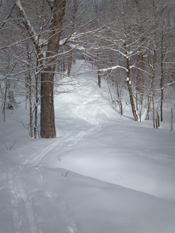
A couple photos I took on the up:
Looking up ...
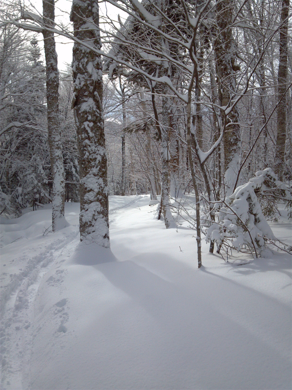
and, later, looking down:
Maybe halfway up, one skier came down to get first tracks. Not too long thereafter someone on tele gear was the second. Still plenty of canvas for me to work with.
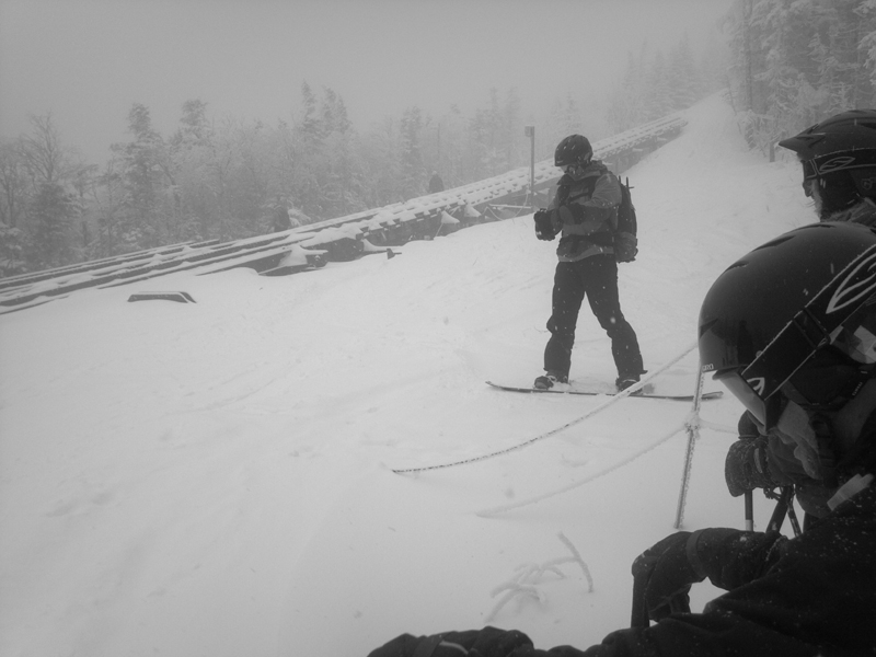
Now I am not exactly the world's fastest skinner so it didn't surprise me, even if it did disappoint me a little, to hear someone gaining on me. OK, fourth tracks it would have to be. Then I saw it wasn't one person but ... SEVEN :-o ... 10th tracks didn't really have such a nice ring to it :sad: ... but as they caught up with me I learned they were in an AIARE Level II class so I figured they were heading up into the slides and wouldn't be skiing down before me :-D .
At just about exactly the two-hour mark, after passing the first rescue cache, I reached my objective, a gully that marks the first major avy runout across the trail. This is looking up the trail but down into the runout:
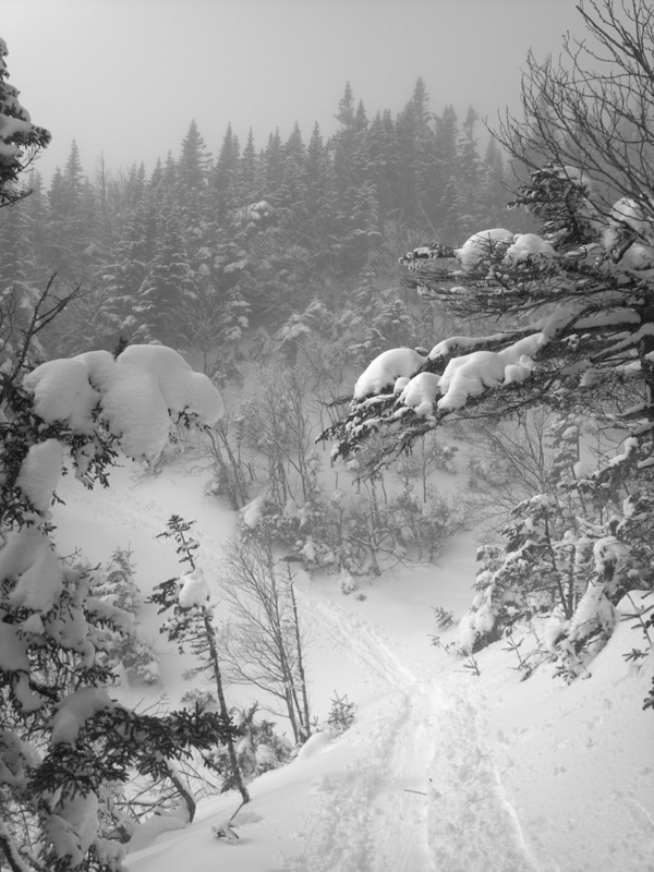
(Droid photo and I didn't have my glasses on so apparently I'd set effects to black-and-white)
The GOS is not in the avy forecast area and I'd left the Pinkham pack room before the morning advisory was posted, but with 12.7" of new snow reported at the summit and substantial winds during the storm, I assumed avy danger up in the slides would be Considerable if not High. My plan all along was to play it safe and not cross any runout zones - actually there is an extremely small one below this one but I was alongside the AIARE II group at the time and the leader said that one has run across the trail maybe once in 100 years. So here I transitioned and started down. (Estimated elev.: 3900', gain of around 1900' from Pinkham base 2032'.)
The snow was a bit sticky but turning wasn't too tough. What a classic New England trail - some nice steep drops, sometimes narrow, often wider, twisting and turning with the terrain. All hail the CCC. I reached the base and decided against taking another lap there or on the Sherbie given the now above-freezing temps down low - plus I knew I'd have plenty more skinning in my near future.
to be cont'd ...
THURS 2/28 - GULF OF SLIDES TRAIL
The class started Friday morning at the AMC center at Crawford Notch so I'd planned to drive up no later than the night before. When Mt. Washington was forecast to get around a foot of snow Wednesday night, I decided to go up as early as possible Thursday. Based on where I expected course field work to take place, I decided on my free day to take my first tour up the Gulf of Slides Trail, though not all the way up into the slides themselves because of avalanche danger combined with the knowledge I did not yet have on how to assess conditions.
I arrived at Pinkham Notch at 8 a.m. and was heading up the trail by 8:40. Eyeballing it I'd say there was 8" of new snow at the base, and though I'd feared it would be wet as temps were close to freezing, at that hour it was chalky. At the split for the GOST from the base a skier descended from the Sherburne and it looked like he had nice powder turns. But I was surprised to see breaks of blue sky and no wind, and as I began climbing the temps rose - snow started sliding off spruce limbs at lower elevations, and the powder began getting a little sticky.
Someone had laid down a skin track on GOST but it appeared to be just one skier. Whoever it was, I figured the odds weren't great they'd be heading up into the slides because of the avy threat, but I'd be good with second tracks. Maybe a third of the way up another skier apparently came in (not sure where from) but I'd be good with third tracks ...
A couple photos I took on the up:
Looking up ...
and, later, looking down:
Maybe halfway up, one skier came down to get first tracks. Not too long thereafter someone on tele gear was the second. Still plenty of canvas for me to work with.
Now I am not exactly the world's fastest skinner so it didn't surprise me, even if it did disappoint me a little, to hear someone gaining on me. OK, fourth tracks it would have to be. Then I saw it wasn't one person but ... SEVEN :-o ... 10th tracks didn't really have such a nice ring to it :sad: ... but as they caught up with me I learned they were in an AIARE Level II class so I figured they were heading up into the slides and wouldn't be skiing down before me :-D .
At just about exactly the two-hour mark, after passing the first rescue cache, I reached my objective, a gully that marks the first major avy runout across the trail. This is looking up the trail but down into the runout:
(Droid photo and I didn't have my glasses on so apparently I'd set effects to black-and-white)
The GOS is not in the avy forecast area and I'd left the Pinkham pack room before the morning advisory was posted, but with 12.7" of new snow reported at the summit and substantial winds during the storm, I assumed avy danger up in the slides would be Considerable if not High. My plan all along was to play it safe and not cross any runout zones - actually there is an extremely small one below this one but I was alongside the AIARE II group at the time and the leader said that one has run across the trail maybe once in 100 years. So here I transitioned and started down. (Estimated elev.: 3900', gain of around 1900' from Pinkham base 2032'.)
The snow was a bit sticky but turning wasn't too tough. What a classic New England trail - some nice steep drops, sometimes narrow, often wider, twisting and turning with the terrain. All hail the CCC. I reached the base and decided against taking another lap there or on the Sherbie given the now above-freezing temps down low - plus I knew I'd have plenty more skinning in my near future.
to be cont'd ...
Last edited: