Abubob
Well-known member
Seems bad enough. These guys sure aren't happy about it.

Welcome to AlpineZone, the largest online community of skiers and snowboarders in the Northeast!
You may have to REGISTER before you can post. Registering is FREE, gets rid of the majority of advertisements, and lets you participate in giveaways and other AlpineZone events!


I hope its not the same guys that called for a cold snowy winter!Inactive Atlantic hurricane season a ‘head-scratcher’
http://seattletimes.com/html/nationworld/2021737969_hurricaneseasonxml.html
I hope its not the same guys that called for a cold snowy winter!
No kidding! When it comes to hurricanes this season - "crickets"!
This is good I don't want another Sandy one was more then I needed for a messy disaster at my job bad memories and health because of it.

I'm gonna go ahead and call BS on those "numbers" The "track" was/is not as important as the fact that it hit at high tide on unprepared stretch of coast. This IMHO was most destructive. The first major hurricane to hit in my lifetime was Gloria. Being the history buff that I am I spoke to some old-timers who said it was nothing compared to the hurricane of '38. I'm not saying track is not important, '38 barely effected the city. Being prepared, not falling into a jaded "boy who cried wolf" syndrome and knowing that IT CAN happen here are the only things that will prevent more Sandy like destruction...The numbers have been done on Sandy and the track it took was a 1 in 700 years occurance, you should be fine.
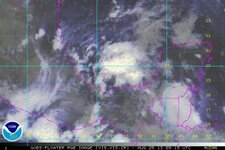
Meanwhile, something is a-brewing in the Eastern Caribbean.
I'm gonna go ahead and call BS on those "numbers" The "track" was/is not as important as the fact that it hit at high tide on unprepared stretch of coast. This IMHO was most destructive. The first major hurricane to hit in my lifetime was Gloria. Being the history buff that I am I spoke to some old-timers who said it was nothing compared to the hurricane of '38. I'm not saying track is not important, '38 barely effected the city. Being prepared, not falling into a jaded "boy who cried wolf" syndrome and knowing that IT CAN happen here are the only things that will prevent more Sandy like destruction...
I'll agree with you that the lack of preparation was the most devastating effect from Sandy, but the rare track increased surge on that unprepared coast.
Interesting article on Sandy here: http://www.wunderground.com/blog/JeffMasters/comment.html?entrynum=2510