• Welcome to AlpineZone, the largest online community of skiers and snowboarders in the Northeast!

    You may have to REGISTER before you can post. Registering is FREE, gets rid of the majority of advertisements, and lets you participate in giveaways and other AlpineZone events!

The Big One Analysis: February 13th, 2014 Storm Observations

Abominable

Active member
Joined
Jan 18, 2013
Messages
481
Points
28
Anyone up for Berkshire East tomorrow?

Dammit, they just released us from work, and I've been dicking around in this thread all day and actually have an hour's worth of work to do before I can get out of here. I could've hit this little window of weather and been up in Charlemont by 8 pm....

That's what I get for being a total slacker. I'll keep an eye on the weather and might try to join you guys regardless. Otherwise, keep an eye out for me at Catamount tomorrow.
 

wa-loaf

Well-known member
Joined
Jan 7, 2007
Messages
15,109
Points
48
Location
Mordor
Seems to be wrapping up here. 8-10 but maybe a little more overnight?
 

lstone84

Member
Joined
Oct 8, 2012
Messages
131
Points
16
headed to Smuggs late tonight, 18-24 forecasted. Little sleep but tomorrow is going to be good.
 
Joined
Sep 15, 2012
Messages
780
Points
16
Location
Boston
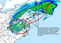
Once the dry slot hits the Northern MA border, it will halt its progress as the storm begins to catch up with the mid-level lows. The bands will begin to pivot in NNE. Where those bands set up and basically stall is where the winners will be. I'll be making my call of where to go soon based on this.

It may not be over in SNE, that ball of rain near DC associated with the surface low will track with it, bringing a second batch of precip to dryslotted areas.

post-904-0-18188300-1392324090.jpg
 

Abominable

Active member
Joined
Jan 18, 2013
Messages
481
Points
28
Thanks BB for all your contributions. What's the timing here? We thinking roads clear at six a.m.? Five a.m.? Talking about NYC to points north.
 

WJenness

Active member
Joined
Oct 18, 2007
Messages
3,024
Points
38
Location
Lowell, MA
On the ground at Sunday River...

Got here about 1PM, skied until they wouldn't let me on the lift anymore. The last 45 mins - hour the intensity really started picking up.

When I got back to the condo, there was about 2" on the car, and the snow was coming down heavy enough that I could barely make out the mountain from the condo (slopeside)...

Most of what falls will be untracked from today's skiers, as A: The intensity started to ramp up so late in the day, and B: The mountain was not busy this afternoon. I had several runs where I didn't see another soul until I got back to the lift.

TR coming after a trek to the phoenix for a beer or two and some food.

-w
 

WJenness

Active member
Joined
Oct 18, 2007
Messages
3,024
Points
38
Location
Lowell, MA
Charlie Lopresti (Weather guy for WGME 13 in Portland, ME) just said that the snow bands coming into the mountains right now are of an intensity that he hasn't seen since last year. (the weekend of the Summit @ Sugarloaf)... That makes me happy.:)
:daffy:

-w
 
Joined
Sep 15, 2012
Messages
780
Points
16
Location
Boston
Thanks BB for all your contributions. What's the timing here? We thinking roads clear at six a.m.? Five a.m.? Talking about NYC to points north.

Hmmm tough one. I don't really know what's going on for NYC on north. I'm sure BG would know. My two cents are that roads will not be clear from Albany on north until after 10am Friday.

ETA: Roads to Catamount are going to be very tricky as well. Berks are going to get smoked tonight into the AM there.
 

Abominable

Active member
Joined
Jan 18, 2013
Messages
481
Points
28
Hmmm tough one. I don't really know what's going on for NYC on north. I'm sure BG would know. My two cents are that roads will not be clear from Albany on north until after 10am Friday.

ETA: Roads to Catamount are going to be very tricky as well. Berks are going to get smoked tonight into the AM there.

Whoops, I think I got my BG and BB confused, as to who lives where. Thanks regardless, and we'll just have to see how it goes! The ski vehicle is adequate, just might be a slow trip.
 

catsup948

New member
Joined
Dec 6, 2007
Messages
1,026
Points
0
Location
Shelburne Falls, MA
We got about 7 inches in round one I'm hoping we get around that for round 2. Fingers crossed on 12 inches total.

Sent from my SCH-I545 using Tapatalk
 
Joined
Sep 15, 2012
Messages
780
Points
16
Location
Boston
Low is going bonkers off the Jersey shore. Already down to 988mb and rapidly deepening. As a result thunderstorms are exploding just off or on the coast and moving due north. Thundersnow en route.
 
Last edited:

Bene288

New member
Joined
Nov 25, 2011
Messages
1,026
Points
0
Location
Albany, NY
Local mets in Albany calling for another 8"-12" tonight on top of 7" that fell today. Berks will be wild tomorrow. Family on the edge of the Berks, about 20 minutes from Jiminy reporting 12" with another 12" forecasted to fall through the night. Fluffy stuff too.
 

flightschool

Member
Joined
Dec 29, 2013
Messages
91
Points
8
1 in in lincoln nh....what the hell

I've been checking the radar religiously for northern/central VT. They are getting robbed. Almost no snow. Radar over loon looked way better, sad to hear they are doing so poorly. This storm has taken a nasty vertical movement...Maine and Berkshires are the places to be tomorrow :oops::oops:
 
Top