-
Welcome to AlpineZone, the largest online community of skiers and snowboarders in the Northeast!
You may have to REGISTER before you can post. Registering is FREE, gets rid of the majority of advertisements, and lets you participate in giveaways and other AlpineZone events!
You are using an out of date browser. It may not display this or other websites correctly.
You should upgrade or use an alternative browser.
You should upgrade or use an alternative browser.
March 13th (Don't Crucify me!)
- Thread starter Boston Bulldog
- Start date
Boston Bulldog
Member
GFS caves way north and is more amped. The king (EURO) rules again.
Boston Bulldog
Member
Heavy Heavy snows

dmw
New member
- Joined
- Feb 29, 2012
- Messages
- 305
- Points
- 0
Any idea of projected timing? I have to pick someone up at the airport midday Wednesday... A Liftopia for Crotched Thursday... Wondering if I'll even be able to get there!
billski
Active member
Yeah right. If this comes to pass, I'm quitting my job until July!
billski
Active member
wa-loaf, If we believe BB, I'm afraid snow tires will be no match for the incoming. You'll need to rent a Humvee nonetheless!I've got a problem with one of my tires. If I have to replace it I'm not likely to buy new snows at this point and will just put the all seasons on. You are all welcome.
flightschool
Member
- Joined
- Dec 29, 2013
- Messages
- 91
- Points
- 8
Will be at Loon or SR weds/thurs if this plays out. Glad I kept the snows on, almost took them off this weekend.
billski
Active member

Boston Bulldog
Member
wa-loaf, If we believe BB, I'm afraid snow tires will be no match for the incoming. You'll need to rent a Humvee nonetheless!
That's not all one storm. A couple 1-3 type deals will be swinging through NNE during the next couple days.
billski
Active member
NWS sez:Any idea of projected timing? I have to pick someone up at the airport midday Wednesday... A Liftopia for Crotched Thursday... Wondering if I'll even be able to get there!
BUT
THERE ARE QUESTIONS ON TIMING. THE GGEM IS FASTEST...BRINGING THE
LOW PAST NANTUCKET BY WEDNESDAY EVENING. THE GFS IS ABOUT 4-6 HOURS
SLOWER...THE ECMWF ANOTHER 6 HOURS SLOWER WITH PASSAGE AT THE START
OF THURSDAY.
billski
Active member
Yeah, but 3 feet? I'd be thrilled at 1/3 of this. NWS anticipates a high moisture content. That would be tough.That's not all one storm. A couple 1-3 type deals will be swinging through NNE during the next couple days.
billski
Active member
NWS Isn't sticking it's neck out yet....
ONE COMPONENT...THE SHORTWAVE OVER THE NORTH PACIFIC...IS STILL FAR
FROM LAND AND WILL REMAIN SO FOR AT LEAST ANOTHER 24 HOURS. SO
CONFIDENCE IN THE DETAILS OF THE STORM REMAIN LOW. BUT MODELS HAVE
BEEN CONSISTANT IN ADVERTISING STORMINESS FOR WEDNESDAY-
THURSDAY...SO CONFIDENCE IN POPS IS INCREASED FROM PREVIOUS
FORECASTS. WILL INDICATE HIGH-END LIKELY POPS DURING THE HEIGHT OF
THE STORM AND MAINTAINING CHANCE POPS THROUGH THURSDAY EVENING IN
RECOGNITION OF THE SLOWER ECMWF SOLUTION.
billski
Active member
snow-forecast.com is onboard with 12" for all of New England. Flip a coin, pick any mountain ")
This could require some pre-storm staging.

This could require some pre-storm staging.
billski
Active member

A foot in 12 hours? WNY better get to the pool store and stock up on snorkels!
Boston Bulldog
Member
Yeah, but 3 feet? I'd be thrilled at 1/3 of this. NWS anticipates a high moisture content. That would be tough.
Don't kill the messenger
you gotta say what the masses wanna hear.billski
Active member
If there is only one thing I've learned about the NWS, it's this. It's not about the weather. It's about safety. It's right in their mission statement. It's more about safety than the weather. Meteorologists work in the boiler room, but the safety guys pilot the ship.Don't kill the messenger
billski
Active member

156 hours from now. u due da mat.
billski
Active member
Euler
Active member
Oh my lord in heaven...please hear my prayers...
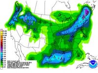
Here's a sight for sore eyes. 7 day accumulation. use 10-12" snow-qpf equivalent. What's that? A 2.7 QPF?

SnowRock
Active member
Here's a sight for sore eyes. 7 day accumulation. use 10-12" snow-qpf equivalent. What's that? A 2.7 QPF?
I could get down with this! Was suppose to head up to stowe Thursday, thinking Of heading up from NYC Wednesday night right after work instead.
Similar threads
- Replies
- 1
- Views
- 352
- Replies
- 34
- Views
- 1K
- Replies
- 2
- Views
- 595