• Welcome to AlpineZone, the largest online community of skiers and snowboarders in the Northeast!

    You may have to REGISTER before you can post. Registering is FREE, gets rid of the majority of advertisements, and lets you participate in giveaways and other AlpineZone events!

2014-2015 Winter Forecast (here we go)

xwhaler

Active member
Joined
Nov 26, 2007
Messages
2,943
Points
38
Location
Seacoast NH

BenedictGomez

Well-known member
Joined
Jan 26, 2011
Messages
12,182
Points
113
Location
Wasatch Back
Lots of unsettled and precipitous weather on the models over the next 10 days, unfortunately it mostly looks like rain.

The good news (hopefully) is in most cases it's not raining because it's 45 degrees, but because it's 35 degrees, so hopefully the temps can come down just a bit and turn to snow on some of the future model runs.
 

SnowRock

Active member
Joined
Oct 16, 2012
Messages
320
Points
28
Location
Jersey City, NJ
My ADK trip this weekend is looking to be more ice skating than skiing.

For my Stowe trip... Ive gone from contemplating leaving from the office Wednesday/cheap hotel before house rental kicks in to get in all day thursday, to leaving at 4 am from NJ to get in some time thursday, to working from home until 1 thursday and just hitting up pro pig upon arrival to the area.
 

BenedictGomez

Well-known member
Joined
Jan 26, 2011
Messages
12,182
Points
113
Location
Wasatch Back
18z GFS came in a bit colder for both of the near-term rain/mix/snow events. Hopefully this is a trend and not a 1-run aberration.

Also develops some big snow in the out dates, but that's fantasy stuff at this point.
 

JonD

Member
Joined
Nov 21, 2007
Messages
48
Points
6
Location
Boston
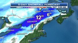
Tim Kelley is making things interesting for this weekend.


attachment.php

https://twitter.com/surfskiwxman/status/580527743093358592
 

Attachments

  • CA5y598WwAIjrt0.jpg
    CA5y598WwAIjrt0.jpg
    37.1 KB · Views: 133

JDMRoma

Well-known member
Joined
Jan 20, 2013
Messages
1,258
Points
48
Location
Hudson NH
If that forecast is real Saturday is it !
I'd do Cannon !


Sent from my iPhone using AlpineZone
 

catsup948

New member
Joined
Dec 6, 2007
Messages
1,026
Points
0
Location
Shelburne Falls, MA
This has some nice potential for northern ski country. Its just ugly looking around here. Dirt, grass, snow, puddles, mud, refrozen mud, ice, yuck!
 

BenedictGomez

Well-known member
Joined
Jan 26, 2011
Messages
12,182
Points
113
Location
Wasatch Back
is this real?

It's ballsy-aggressive, but it's possible.

This is where I was commenting there's good potential IF the models come in colder. He must either believe that happens OR he sees something atmospherically that suggests better dynamics than the models are picking up on (better timing, colder, lingering, etc..).

Frankly, if you just look at the models, Monday/Tuesday looks better for snow than Friday/Saturday.

Here's the GFS output through mid-day Tuesday, verbatim to the model most of this is on Monday.

gfs_asnow_neus_26.png


The pattern is energetic and wet, this is the reason I booked a week in northern Vermont for this timeframe, the writing has been on the wall for several weeks now that later March / early April have really special potential. Crossing fingers and toes it pans out. Currenly have Smuggs, Jay, Stowe, and MRG on the itinerary!
 

BenedictGomez

Well-known member
Joined
Jan 26, 2011
Messages
12,182
Points
113
Location
Wasatch Back
I'll tell you one thing, if northern Vermont squeezes out anything even remotely close to 12" from this first "cointoss precipitation" event Thurs/Friday, I am going to be happier than a pig in slop with a giant food-source within reach.
 
Top