Not Sure
Well-known member
Just updated
THankS for the upDate
Welcome to AlpineZone, the largest online community of skiers and snowboarders in the Northeast!
You may have to REGISTER before you can post. Registering is FREE, gets rid of the majority of advertisements, and lets you participate in giveaways and other AlpineZone events!
Just updated
")


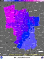
 mountains in that dark blue?
Never said it was elevation difference...
That's ending 7am Thursday, not 7 am tomorrow and even 7pm as the earlier maps were showing.
I'm focused on the best combo of max snow by opening to,or row and least rain while riding in that snow. Not sure any of those maps answer that question.
Still surprised they're still calling for 14-18 in the Cats w these snow totals so far. Any ski View attachment 14578mountains in that dark blue?
Sent from my iPad using AlpineZone
Cannon has received 6" as of 8pm. Is it worth going with the potential rain tomorrow?