• Welcome to AlpineZone, the largest online community of skiers and snowboarders in the Northeast!

    You may have to REGISTER before you can post. Registering is FREE, gets rid of the majority of advertisements, and lets you participate in giveaways and other AlpineZone events!

Jan 4-5 Event

billski

Active member
Joined
Feb 22, 2005
Messages
16,207
Points
38
Location
North Reading, Mass.
Website
ski.iabsi.com
Something could be brewing. Granted, it's six days away, this is worth watching

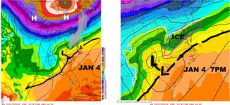
MID-ATLANTIC - Per WxRisk
"NOTIFICATION JAN 4-5 EAST COAST LOW... if it stays south IF... IF.. poses the threat of SNOW & ICE for Middle Atlantic region

Given how awful December has been with respect to winter weather lovers over the East Coast there are number reasons to be skeptical about this potential event. On the other hand to ignore this potential event and say nothing until it's only 48 or 60 hours away is NOT what WxRisk is about. There are plenty of examples of winters which seem to be going along quite snowless then a surprise event hits.

This image show with the surface map from the European model from early Monday morning look like. North of the white line the precipitation is snow but the low level cold air may be strong enough to allow for the potential of significant icing over large portions of Virginia and Maryland -- SEE PURPLE AREA."

attachment.php
 

Attachments

  • jan4-5.jpg
    jan4-5.jpg
    79.2 KB · Views: 342

catsup948

New member
Joined
Dec 6, 2007
Messages
1,026
Points
0
Location
Shelburne Falls, MA
I was reading there could be multiple chances next week. Cold will try to suppress everything and there is no blocking so we can't expect a massive storm in the pattern but the cold will be around. Over running systems with a heavy front end thump and a change to sleet/frz/rain could be in store for at least southern new england. Similar to last year the cold might be to much for these systems to move up into northern new england.
 

mriceyman

New member
Joined
Jan 4, 2012
Messages
1,344
Points
0
Location
cnj
Another system that looks wet. Not good. Maybe luck will be on our side this time.


Sent from my iPhone using AlpineZone
 

xwhaler

Active member
Joined
Nov 26, 2007
Messages
2,943
Points
38
Location
Seacoast NH
I'm skiing somewhere on Sunday...how much and what form of precip falls will determine where I am.
 

billski

Active member
Joined
Feb 22, 2005
Messages
16,207
Points
38
Location
North Reading, Mass.
Website
ski.iabsi.com
Don't get your hopes up too far. There is definitely precipitation coming. Why type it will take is very uncertain.

The below are valley forecasts. I think the mountains northward from Killington - Cranmore - Sunday Riverrds stand the best chance of staying all snow. Those places could see a noticeable snowfall.


NATIONAL WEATHER SERVICE BURLINGTON VT
915 AM EST TUE DEC 30 2014

BOTH MODELS (GFS and ECMWF) SHOW THE POTENTIAL FOR A BURST OF SNOW SATURDAY NIGHT, BUT THEREAFTER PRECIP COULD BECOME MIXED GOING INTO SUNDAY MORNING. -


NATIONAL WEATHER SERVICE ALBANY NY
845 AM EST TUE DEC 30 2014

SNOW APPEARS MOST PROBABLE SATURDAY NIGHT
WITH WARMER AIR RAPIDLY MOVING IN SUNDAY MORNING CHANGING SNOW TO
RAIN OR RAIN/SNOW MIX. ...GIVEN THE STORM TRACK IT IS POSSIBLE
FOR SOME SLEET AND/OR FREEZING RAIN BUT AGAIN CONFIDENCE IS LOW AT
THIS TIME.

NATIONAL WEATHER SERVICE GRAY ME
600 AM EST TUE DEC 30 2014

I THINK THAT NORTHERN AREAS
ARE LIKELY TO SEE A MOSTLY SNOW EVENT FROM THIS TRACK WITH
POSSIBLY SOME SLEET TOWARDS THE END. THERE WILL BE A TRANSITION
FROM SNOW...TO SLEET AND POSSIBLY FREEZING RAIN ACROSS THE
SOUTH...BUT 5 DAYS OUT IT IS ANYONES GUESS WHERE THE MIXING WILL
BE AND ANY SHIFT IN THE TRACK WOULD DRASTICALLY CHANGE THE
FORECAST.
 
Last edited:

lstone84

Member
Joined
Oct 8, 2012
Messages
131
Points
16
GFS, GFS parallel, Euro all show a storm for late weekend, hope it stays far enough south for all snow


Sent from my iPhone using AlpineZone
 
Top