• Welcome to AlpineZone, the largest online community of skiers and snowboarders in the Northeast!

    You may have to REGISTER before you can post. Registering is FREE, gets rid of the majority of advertisements, and lets you participate in giveaways and other AlpineZone events!

Manitoba Mauler 2.0: 2/15 threat

Joined
Sep 15, 2012
Messages
780
Points
16
Location
Boston
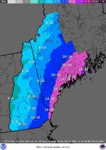
The trend is that the storm will dig farther south and strengthen more; this means that the storm will track closer to the coast and more snow will be delivered to the ski areas.
 

moguler6

New member
Joined
Mar 16, 2009
Messages
148
Points
0
Gray ME NOAA has weighed in.


StormTotalSnowFcst.png
 

bigbog

Active member
Joined
Feb 17, 2004
Messages
4,882
Points
38
Location
Bangor and the state's woodlands
Eastern Maine! Camden SnowBowl!!!
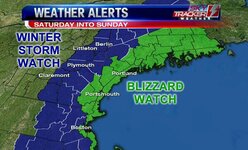
Also...think Lost Valley may get pretty close to the max....would be great for them.
It's a small, low priced place....looking good....hopefully the Loaf might get some if the storm holds together for a while, which it looks like a good possiblity...fwiw
 

Tin

Active member
Joined
Oct 14, 2009
Messages
2,996
Points
38
Location
ZooMass Slamherst
Fear the wind with this one. Not a ton of snow like the last few but we are talking some serious wind, like sustained at 40+ throughout southern NE with hurricane force gusts. A few thousand feet up in ski could could be wild and damaging given the weight on the trees. This could really screw things up.
 

BenedictGomez

Well-known member
Joined
Jan 26, 2011
Messages
12,174
Points
113
Location
Wasatch Back
00z Canuck & 00z GFS are both in, and both have moved south. This should tuck it into the coast...might be getting interesting for ski country. This is turning into the neverending winter of "correct" storm adjustments.

EDIT: Added depictions of both models at 12z Sunday.

gfs_mslp_pcpn_frzn_us_10.png


gem_mslp_pcpn_us_10.png
 
Last edited:

Puck it

Well-known member
Joined
Oct 26, 2006
Messages
9,691
Points
48
Location
Franconia, NH
Yeah 20mmph would be nice.

NWS Cannon Forecast at 3720'

Snow with areas of blowing snow before 10am, then snow likely with areas of blowing snow between 10am and 1pm, then areas of blowing snow and a chance of snow after 1pm. High near 1. Very windy, with a north wind around 50 mph, with gusts as high as 65 mph. Chance of precipitation is 90%.
 

fcksummer

Member
Joined
Dec 26, 2013
Messages
238
Points
18
Location
Standing Sideways
Website
fck-summer.tumblr.com
Yeah 20mmph would be nice.

NWS Cannon Forecast at 3720'

Snow with areas of blowing snow before 10am, then snow likely with areas of blowing snow between 10am and 1pm, then areas of blowing snow and a chance of snow after 1pm. High near 1. Very windy, with a north wind around 50 mph, with gusts as high as 65 mph. Chance of precipitation is 90%.

Cannon looks pretty brutal this weekend. I might think about Bretton Woods to escape some of the wind.

itYPZA7.png
 
Top