billski
Active member
Got some wet stuff coming in for Friday, but No. VT could see appreciable snow on Saturday
Welcome to AlpineZone, the largest online community of skiers and snowboarders in the Northeast!
You may have to REGISTER before you can post. Registering is FREE, gets rid of the majority of advertisements, and lets you participate in giveaways and other AlpineZone events!

I last day at Smuggs would be a powder day. Fingers crossed.
") it won't be powder. It will be snow, heavy snow at that. Got Wax?
it won't be powder. It will be snow, heavy snow at that. Got Wax?N NH into Western ME looks pretty good---come on elevation special! Hoping for some wet powder at Cannon on Saturday!
Stay away from Cannon it will be a zoo.How busy will Cannon be on Saturday? I know that the tram will be closed and it will be Bode-Fest. I've never been there on this weekend.
I am committed to day tripping from home on Saturday since Sunday is zombie Jesus day. I'm going to chase the best compromise between drive time and fresh snow. Right now Cannon, Bretton Woods, Burke, Waterville Valley, and Killington are all on the short list.
Can't speak for NH, but I can say that most all areas in Vermont are pretty mellow, few lines to speak of and lots of outdoor grilling, drinking and sun-tanning.Stay away from Cannon it will be a zoo.
How busy will Cannon be on Saturday? I know that the tram will be closed and it will be Bode-Fest. I've never been there on this weekend.
I am committed to day tripping from home on Saturday since Sunday is zombie Jesus day. I'm going to chase the best compromise between drive time and fresh snow. Right now Cannon, Bretton Woods, Burke, Waterville Valley, and Killington are all on the short list.
Trails will be packed and no parking.Honestly last year it was only insane in the lodge, other than that it was pretty normal......
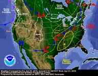
Josh Fox said:A strong cold front advances toward New England Friday night along with the 2nd piece of this storm. For a time it will remain a relatively weak low pressure center, but it will have a healthy amount of moisture and it will bring this moisture northeast out of the Plains as cold air descends southeast out of Canada. The storm will then strengthen very early Saturday and bomb off the New England coast later Saturday. Precipitation may remain rain for a few hours Friday night and then change to snow early Saturday around dawn. If the storm can deepen quickly Friday night, the snow could potentially be heavy for several hours and accumulate 6-10 inches by midday Saturday before tapering off during the afternoon. If the storm is slow to mature, we will be stuck with lighter snows.
Sounds like the partee not to miss. Chicks, Guys, flowing beer and top bands. Shuttles from Portland, Providence, Boston, Hartford and Albany. Woodstock on Ice! Going to be EPIC.Trails will be packed and no parking.
Forecast for paraonid flatlanders.〽❄❅;900071 said:^ TWC isn't showing much for the weekend, they have Monday night and Tuesday having the most potential.
Most recent model outputs of the GFS, Canadian, and NAM (4km) for northern Vermont yields 4", 2", and 5", of snow, respectively.
BTV put out a blurb late yesterday that they think 6" to 7" is likely in the higher parts of the mountains.
I'll definitely be tuning into the 12z runs today.