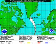
Rare(only 4th since 1851) January tropical storm Alex strengthened overnight and winds are at 70mph. Why are we watching it closely if it poses no threat to us you ask? Because it will likely have implications for the rest of Winter. If it stays on track, it could set a block up and force cold air down, and along with that will come snow.
-
Welcome to AlpineZone, the largest online community of skiers and snowboarders in the Northeast!
You may have to REGISTER before you can post. Registering is FREE, gets rid of the majority of advertisements, and lets you participate in giveaways and other AlpineZone events!
You are using an out of date browser. It may not display this or other websites correctly.
You should upgrade or use an alternative browser.
You should upgrade or use an alternative browser.
Winter Forecast 2015-2016
- Thread starter dlague
- Start date
from_the_NEK
Active member
Rare(only 4th since 1851) January tropical storm Alex strengthened overnight and winds are at 70mph. Why are we watching it closely if it poses no threat to us you ask? Because it will likely have implications for the rest of Winter. If it stays on track, it could set a block up and force cold air down, and along with that will come snow.
I just came here to post about the rare January Hurricane too.
That block could end up just making it cold and dry here instead. However, I don't think the models will really know what to do with a hurricane this time of year. They currently have the remnants retrograding into Labrador/Northern Quebec.
I do wonder if the southern tip of Greenland will get a tropical downpour or and epic dump of snow?
Anything can happen but this same thing is what set up the blizzard of 1978.
from_the_NEK
Active member
According to the Mt Mansfield snow depth chart, the mountain is 60% below average depth for this time of year. It would take a 25+ inch storm to get to an average depth of ~42".
:-?
:-?
Tin
Active member
Things are starting to look...juicy.

ss20
Well-known member
Nearly all the ensembles have a Flatlands storm for next Saturday-Sunday.
Dear Ullr, I REALLY REALLY hope next weekend gets us lots and lots of RAIN! Please, I really want next weekend to be a BIG, FAT RAIN STORM with 50 degree temperatures. I'm tired of skiing, so I want RAIN! Please deliver.
With WARM regards,
A guy who really likes SUMMER
One 2ft blizzard coming up :wink:
Anything can happen but this same thing is what set up the blizzard of 1978.
That would be awesome. I was at college in NH in 1978 and that storm turned into a 3 day event with a total of close to 5 feet of snow.
I remember jumping off the roof of my 5 story dorm into 10 foot deep snow banks.
Although we've had a crappy beginning to the season, pretty sure the sustained cold and big snows in southern NE last year didn't really get going until the last week of January. In fact it looks like we had temps in the 40's and an inch plus rain event in CT around the 18th of January. First big snow storm, other than at Thanksgiving happened around 1/24. Short and sweet of it is that I've got hope that this season is about to turn itself around and make all the bad weather in December a distant memory. Fingers crossed.
skiberg
Member
- Joined
- Sep 28, 2010
- Messages
- 588
- Points
- 18
Last year was a bit delayed as well. BUT, we had sustained cold. there is no indication that sustained cold is going to arrive anytime soon. Unless this January hurricane completely messes with the patterns. We may be near normal, or slightly below but nothing dramatic. Storms are around, but the cold does not seem deep enough to fight off the invading warm air and we get rain/sleet/snow and a general mess. It seems like storm tracks have to be nearly perfect this year for us to get the goods. I have no doubt that will happen at some point, but based upon what I have read it will not be the norm. It will be the infrequent and lucky event when it happens.
ss20
Well-known member
Friday night-Saturday is still on the radar. Last GFS run POUNDED northern NJ up through Boston.
BenedictGomez
Well-known member
All major models now locked on an absolute doozy of a major snowstorm somewhere in the Friday to Saturday timeframe. Keep in mind, we are STILL IN THE "FOOTBALL PULLING" TIMEFRAME, so you'd want to see this STILL on the models on Tuesday, but.......
Could be a big one Weezy.


Could be a big one Weezy.
catsup948
New member
Big totals for NYC! Wisp, West Virginia buried. Hopefully we can get this to tuck a bit nw.
Tin
Active member
Remember late last January when NYC had big snow totals? That worked out well.
Remember late last January when NYC had big snow totals? That worked out well.
Do I need to start skiing NYC ?
Didn't do much for northern nh last year.
2 feet at my house 2 inches at cannon
God I hope we don't repeat that.
Sent from my iPhone using AlpineZone
Abubob
Well-known member
Yeah, Boston REALLY needs snow.Friday night-Saturday is still on the radar. Last GFS run POUNDED northern NJ up through Boston.
Tin
Active member
Do I need to start skiing NYC ?
Didn't do much for northern nh last year.
2 feet at my house 2 inches at cannon
God I hope we don't repeat that.
Sent from my iPhone using AlpineZone
Unfortunately trending that way. Sharp cut off above the Mass Pike.
My reference was a day before the first big storm for southern New England the EURO put 35-50" in NYC. Created panic and chaos since it was the "king" model. It of course busted but still through down two feet plus for southern New England.
It was definitely weird driving up from RI last year starting with 4' on the ground and arriving in Montpelier to see 4" on the ground.
ss20
Well-known member
My reference was a day before the first big storm for southern New England the EURO put 35-50" in NYC. Created panic and chaos since it was the "king" model. It of course busted but still through down two feet plus for southern New England.
I don't think I could ever forget that weekend. I remember getting in the car Saturday morning and driving to work thinking about how there's been no big storm this year. Saturday night I come home and found this forum had EXPLODED with posts on a storm which would bring us 3-4 FEET of snow (favorite weather quote: The ERUO just went Blizzard of 78...or full retard). The next day my boss showed me the weather report and the total amount was stupidly insane like 4-5 feet.
And then it fizzled... :roll:
bigbog
Active member
I think this weekend looks OK in Northern NH!
Also is looking pretty good for Maine too...keep fingers crossed.
VTKilarney
Well-known member
Uh oh. From the Single Chair Weather Blog:
"There are some ominous signs as we head into February as the EPO is expected to flip to positive. This basically means that the jet stream will tighten in the Pacific forcing more unsettled weather out in the west while milder weather dominates eastern North America. There is a long way to go still and 2 weeks of generally favorable weather in front of it so lets not get too far ahead of ourselves. "
"There are some ominous signs as we head into February as the EPO is expected to flip to positive. This basically means that the jet stream will tighten in the Pacific forcing more unsettled weather out in the west while milder weather dominates eastern North America. There is a long way to go still and 2 weeks of generally favorable weather in front of it so lets not get too far ahead of ourselves. "
BenedictGomez
Well-known member
Yup. The long-range shows a warming up at the end of January. Hope it's wrong.
Similar threads
- Replies
- 46
- Views
- 17K
- Replies
- 1
- Views
- 9K
- Replies
- 15
- Views
- 5K
- Replies
- 11
- Views
- 11K