billski
Active member
snow discussion for the weekend, starts at 5:30. Excellent technical discussion
Tim Kelly always winds me up.
FIS:
“I find your lack of faith disturbing.”
-------
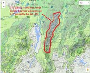
Today, a low pressure system will drag a cold front through the Northeast. Along that front a second weak wave of low pressure will develop. As it moves northeast into Maine it will wrap moisture back into the Adirondacks and Green Mountains and Northwestern Maine. Temps will fall from about 1am tonight on through Friday. Thus above at least 1500' this moisture will fall as snow.
Conditions appear favorable for orographic precip to get really going from mid-tomorrow morning through Friday morning, lingering into Friday mid-day. Temps are going to be great for snow growth (above -10C) but the winds align decently and the moisture saturation looks pretty consistent through the mid-layers of the atmosphere. Thus conditions should be favorable to allow 3-6" to accumulate with pockets of more higher up in wind-favored areas.

Tim Kelly always winds me up.
FIS:
“I find your lack of faith disturbing.”
-------
Today, a low pressure system will drag a cold front through the Northeast. Along that front a second weak wave of low pressure will develop. As it moves northeast into Maine it will wrap moisture back into the Adirondacks and Green Mountains and Northwestern Maine. Temps will fall from about 1am tonight on through Friday. Thus above at least 1500' this moisture will fall as snow.
Conditions appear favorable for orographic precip to get really going from mid-tomorrow morning through Friday morning, lingering into Friday mid-day. Temps are going to be great for snow growth (above -10C) but the winds align decently and the moisture saturation looks pretty consistent through the mid-layers of the atmosphere. Thus conditions should be favorable to allow 3-6" to accumulate with pockets of more higher up in wind-favored areas.