- Joined
- Jul 1, 2001
- Messages
- 31,154
- Points
- 0
Probably pretty unexciting after last week, but any word on who will make out well from this clipper? Hoping some of the natural terrain at Berkshire East gets freshened up....
Welcome to AlpineZone, the largest online community of skiers and snowboarders in the Northeast!
You may have to REGISTER before you can post. Registering is FREE, gets rid of the majority of advertisements, and lets you participate in giveaways and other AlpineZone events!
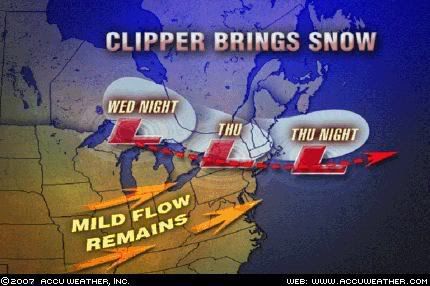
Bush could see 5-10" Thursday through Friday
LOW PRESSURE WILL QUICKLY APPROACH FROM THE EASTERN GREAT LAKES
REGION THIS MORNING...BRINGING LIGHT SNOW INTO LOCATIONS WEST OF
THE HUDSON RIVER VALLEY PRIOR TO NOONTIME. THE LOW WILL MOVE
FROM NORTHWEST TO SOUTHEAST ACROSS UPSTATE NEW YORK IN THE
AFTERNOON...AND WILL RAPIDLY REDEVELOP SOUTHEAST OF LONG ISLAND
IN THE EARLY EVENING. THE SNOW WILL QUICKLY OVERSPREAD EASTERN NEW
YORK AND WESTERN NEW ENGLAND IN THE EARLY AFTERNOON. THE SNOW MAY
BRIEFLY MIX WITH RAIN SOUTH OF ALBANY IN THE MID HUDSON VALLEY
EARLY ON. THE SNOW WILL BECOME HEAVY DURING THE LATE AFTERNOON
COMMUTE WITH SLICK ROAD CONDITIONS POSSIBLE. SNOW ACCUMULATIONS
WILL GENERALLY BE 1 TO 4 INCHES PRIOR TO 6 PM. THE SNOW WILL TAPER
OFF TO SCATTERED SNOW SHOWERS AND FLURRIES TOWARDS MIDNIGHT.
TOTAL SNOWFALL ACCUMULATIONS WILL RANGE FROM 3 TO 6 INCHES OVER
THE CAPITAL REGION...MOHAWK VALLEY...MID HUDSON
VALLEY...TACONICS...LITCHFIELD HILLS AND BERKSHIRES. THE LOWER
CATSKILLS...SCHOHARIE VALLEY...AND HELDERBERGS WILL RECEIVE 4 TO 8
INCHES OF SNOWFALL.
Huh, lookee there.
Maybe tomorrow is the day to take off, but instead of driving 3 hours east to Berkshire East I'll head 1 hr 15 min west to Hunter!

Huh, lookee there.
Maybe tomorrow is the day to take off, but instead of driving 3 hours east to Berkshire East I'll head 1 hr 15 min west to Hunter!
")
Fine. I've had enough of you this season anyway!
You're just mad because the snow is heading more west and not east.
I'm not weeping for you though because you have a season pass to Hunter. It's not such a long drive for you.
But it's much shorter for me!