threecy
New member
Mt. Tecumseh, NH
Date Hiked: 05/25/07
Trails(s) Hiked: Mt. Tecumseh Trail, Sosman Trail, ski area trails
Total Distance: 6-7 miles
Difficulty: Moderate
Conditions: A few isolated patches of mud/running water/ice/snow...mostly dry
Special Equipment Required: None
After more rest, starting to take glucosamine, and trying a bandage wrap under my knee brace, I decided to see if I could do something with about 2,000 vertical feet and 5 or so miles in length. Since it had been awhile, I decided to go with the 'easiest' of the New Hampshire 4k peaks - Mt. Tecumseh.
With spring here, I was able to try Sandwich Notch Road (a nice country road) on my way over to Waterville Vally. Visibility was rather poor due to haze produced by 91 degree temperatures.
The beginning of the Mt. Tecumseh trail was rather easy going, with nothing steep until after the last brook crossing. From here, the trail was a steady moderate climb, until steepening and becoming a bit icy near the top of the ridge. Having not done a hike of any size in a few weeks, I had to stop a few times and catch my breath. I was also amazed how week my injured leg has become from constantly having it elevated and bandaged for the last few weeks.
The ridge itself was fairly flat going until the Mt. Tecumseh Trail split - I took the left (south) option on the ascent, which was rocky and somewhat steep in a few places. It appears there is a good view to the south/southeast at one point on the trail, however the haze made it pretty limited.
The summit itself is in the trees, however there is a eastern lookout ledge just below the summit cairn with decent views of Mt. Tripyramid.
For the descent, I hooked onto the Sosman Trail over to the communications tower (lots of blowdowns in the woods), and then looped over to where the summit quad chairlift once ended.
From here, I continued down the High Country ski trails and over to the Tangent trail. Unlike recent hikes, my knee didn't immediately become a problem on the descent - I made it a good 40 minutes before it became sore and caused a good sized limp, about a third of the way down the Waterville Valley ski area.
All in all, it was nice to be back out on the trails again.
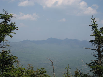
Mt. Tripyramid as seen from Mt. Tecumseh
Date Hiked: 05/25/07
Trails(s) Hiked: Mt. Tecumseh Trail, Sosman Trail, ski area trails
Total Distance: 6-7 miles
Difficulty: Moderate
Conditions: A few isolated patches of mud/running water/ice/snow...mostly dry
Special Equipment Required: None
After more rest, starting to take glucosamine, and trying a bandage wrap under my knee brace, I decided to see if I could do something with about 2,000 vertical feet and 5 or so miles in length. Since it had been awhile, I decided to go with the 'easiest' of the New Hampshire 4k peaks - Mt. Tecumseh.
With spring here, I was able to try Sandwich Notch Road (a nice country road) on my way over to Waterville Vally. Visibility was rather poor due to haze produced by 91 degree temperatures.
The beginning of the Mt. Tecumseh trail was rather easy going, with nothing steep until after the last brook crossing. From here, the trail was a steady moderate climb, until steepening and becoming a bit icy near the top of the ridge. Having not done a hike of any size in a few weeks, I had to stop a few times and catch my breath. I was also amazed how week my injured leg has become from constantly having it elevated and bandaged for the last few weeks.
The ridge itself was fairly flat going until the Mt. Tecumseh Trail split - I took the left (south) option on the ascent, which was rocky and somewhat steep in a few places. It appears there is a good view to the south/southeast at one point on the trail, however the haze made it pretty limited.
The summit itself is in the trees, however there is a eastern lookout ledge just below the summit cairn with decent views of Mt. Tripyramid.
For the descent, I hooked onto the Sosman Trail over to the communications tower (lots of blowdowns in the woods), and then looped over to where the summit quad chairlift once ended.
From here, I continued down the High Country ski trails and over to the Tangent trail. Unlike recent hikes, my knee didn't immediately become a problem on the descent - I made it a good 40 minutes before it became sore and caused a good sized limp, about a third of the way down the Waterville Valley ski area.
All in all, it was nice to be back out on the trails again.
Mt. Tripyramid as seen from Mt. Tecumseh