In researching these peaks in Mike Dickerman's Book and the AMC Guide, I noted that the two can be done in a loop but there is no specific mention of which trails were taken and distance/difficulty/etc. Has anyone hiked both in one trip? What route did you take and how difficult was it? In general, my max is 11-12 miles for a daytrip and I don't really dig steep, smooth, rock scrambles unless there are ladders/handholds. Any advice?
-
Welcome to AlpineZone, the largest online community of skiers and snowboarders in the Northeast!
You may have to REGISTER before you can post. Registering is FREE, gets rid of the majority of advertisements, and lets you participate in giveaways and other AlpineZone events!
You are using an out of date browser. It may not display this or other websites correctly.
You should upgrade or use an alternative browser.
You should upgrade or use an alternative browser.
Whiteface and Passaconway Loop?
- Thread starter thetrailboss
- Start date
David Metsky
New member
The usual loop is up Blueberry Ledges (careful if wet, bare slabs) across the Rollins trail and down Dicey Mill. You can change things a bit by going up the Tom Wiggins trail which is quite steep and doesn't avoid the slabs on Blueberry Ledges. Also you can come down via the Walden, Wonalancet Range, and Old Mast Road, or some combination of those.
The slabs on Blueberry Ledges aren't that bad, there's not far to fall, but it can give some folks the willies. I wouldn't go in the rain if you don't like that sort of thing. There's only two sections that are difficult.
All the shelters in the area are now gone. There's water to be found below the south Whiteface Ledges and by the former site of Camp Rich. The best views are from the south ledges on Whiteface; the actual summit is just a spot in the woods. There are limited views just past the summit of Passaconaway but none from the actual summit their either. Parking for hte loop is at the Fercroft Road parking lot.
Some info on Whiteface and Passaconaway.
-dave-
Thanks, David. How far is this loop, approximately?
David Metsky
New member
I don't have my books here at the office, but my recollection is about 10, slightly more if you use Wonalancet Range or Old Mast Road to descend.
-dave-
-dave-
I don't have my books here at the office, but my recollection is about 10, slightly more if you use Wonalancet Range or Old Mast Road to descend.
-dave-
That's not bad at all...
riverc0il
New member
i did the loop a few years ago. i skipped passaconaway due to fatigue caused by the heat.
http://www.thesnowway.com/hiking/2001/whiteface.htm
i recall only one really exposed section along the cliffs that was not a problem on a dry day. rollins trail seemed like it took forever. the natural bowl formed between the two mountains is really nice and views south from whiteface i recall being pleasant even with overcast and haze. i can't remember the milage, couldn't be much worse than the tris though.
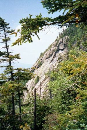
Steve--this is your picture. I assume that the trail does not scale this pitch...
:blink:
riverc0il
New member
correct, iirc... the trail does lead to the top of that cliff where there is a little exposure, great place to stop for a bite to eat. however, the hike to that point is pretty mellow and definitely does not ascend the cliff area.
I've been on the loop three times, only once when dry. It's 11.9 with 3800 feet of vertical (that's I logged in last October)
The trip to the lower ledges (flat near where the Blueberry Cut-off rejoins the main ledge trail) is pretty easy, moderate grades only
The ledges of themselves are several short scrambles, as opposed to the North Tripyamid Slide. I did both of those trips in 1997 on dry days, sinc then I've done the Whiteface Trip twice when wet, most recently 10/05 when the heavy rains flooded parts of southern NH. While the long slide on North Tripyramid appears to provide a long way to fall, there are some short spots requiring a move or two on the upper section of Blueberry Ledge that IMO are harder than North Tri. (again the memory of nine years ago was that North tri was fun.)
The Rollins Trail has a bunch of PUD's but not as bad as the Garfield Trail, maybe similar to Wildcat Ridge when going from the higher A to D, which I think is easier.
I've taken a couple three different ways off of Passaconaway & for my money Dicey's is the best, descending Wonalancet in the rain, solo & tired (I did East Sleeeper also that day) without a view was not fun. On a crisp dry day, maybe with fall foliage, it might be great. Dicey's has much better footing than any of the other options I've taken but the trail up top (getting to the top) is pretty rocky & harder than you might think a wooded peak might be.
It's definetly doable & I'd recommend trying, if too tired, skip going up Dicey's to Passaconaway summit & just descend Dicey's. I think last October in the pouring rain (drizzle when on Ledges) I did the loop in about 9 hours.
pedxing
Member
I did a much weirder loop and loved it - I'd recommend it to anyone who is either a mile monster or willing to do a two day loop.
We headed out the Oliverian Brook trail from Kancamagus and took the Passaconway cutoff to Passaconway - then took Dicey Mill and Wiggins to Whiteface (Rollins trail would also work) and then took the Sleep trail to the Tripyramids, turning back at the North peak and returning to the Kancamagus via Sabbaday brook. It's a bit of a road walk, or a hitch, from the Sabbaday trail head to the Oliverian Brook. I was with my son a friend of his, so I hit the Kanc ahead of them walked towards Oliverian brook with outstretched thumb and got a ride quickly and returned to the Sabbaday trailhead to pcik them.
We actually hadn't planned on doing the whole loop, but the weather was perfect and I couldn't resist showing my son the Tri-Pyramids when we were that close. It was a great trip and it was my first time at Sabbaday Falls (a definite highlight of the trip). If you are a peak bagger, you get four official 4k peaks and a fifth member of the 100 highest.
Last edited:
I did the "traditional" loop in the cold, pouring rain and in fact didn't have any issues at all on the ledges, except being terrified that if I *did* slip I would be in big trouble because I was solo.
There's one spot with a bit of exposure but a trampled path behind some scrub shows that most people take a small detour to avoid it.")
After the ledges, it's into the trees for a long way. From the true summit (somewhere near the junction of the Kate Sleeper Trail) you've got a long walk until you hit the Dicey's Mill Trail. Then it's up (and I recall a water source near one of the former shelter sites?) to the top, nothing extraordinary, and a view beautiful viewpoints up there. Then a long, smooth walk all the way down and out.
album
There's one spot with a bit of exposure but a trampled path behind some scrub shows that most people take a small detour to avoid it.
After the ledges, it's into the trees for a long way. From the true summit (somewhere near the junction of the Kate Sleeper Trail) you've got a long walk until you hit the Dicey's Mill Trail. Then it's up (and I recall a water source near one of the former shelter sites?) to the top, nothing extraordinary, and a view beautiful viewpoints up there. Then a long, smooth walk all the way down and out.
album

This is the stuff I don't like unless there is a good foothold or handhold....
Hey -that picture looks familiar...
Oh, right. I allow linking to AZ!
It's not as bad as it looks, there are handholds on the left out of the frame, plus grabbing into the holes. You'd never slide more than about 4' on this one before you "landed" back in a standing position.
The bigger problem I had was a spot where I had a vertical face to get over. It had plenty of cracks and steps, but I got stuck at about 6' off the ground where I couldn't make the last step without being overbalanced, and so had to hold on with one hand while I took my pack off with the other, rain pouring over me and down the rock, and slide the pack up. Then it was a simple step and jump and I was easily on top.
riverc0il
New member
c'mon TB, grow a pair and just do it! :lol: joking aside, as michael J suggests, it is not as bad as that picture looks. MAN THAT PIC DOES LOOK BAD THOUGH! :lol: it doesn't even look like a hiking trail in that picture, lol. i have had several "oh crap" moments while slab hiking near cliffy areas, whiteface did not give me any problems, it really isn't that bad unless it is wet.
Yeah, in my defense (or offense) I took that picture from an angle designed to make it look bad.
So I am considering doing both Passaconway and Whiteface....up Dicey Mills to Passaconway, over to Whiteface, and down the Blueberry Ledge Trail. Input???
Reverse the loop, I've done it three times, twice in the rain, the clear day had snow above 3,000 feet, (the ledges were clear) over the trail markers in some spots on the Rollins Trail & I would not plan the trip descending the ledges. Some people must descend it, in my three trips (okay so I was the only idiot in the rain) I have not seen anyone on the trail looking to descend them.
FWIW, given a choice of these two perils, descending North Tri Slide or Blueberry Ledges, I'm tempted to choose North Tri. South Tri's slide over the ledges even if that is a winter descent down South Vs. a summer on Whiteface.
FWIW, given a choice of these two perils, descending North Tri Slide or Blueberry Ledges, I'm tempted to choose North Tri. South Tri's slide over the ledges even if that is a winter descent down South Vs. a summer on Whiteface.
I've got reservations about scrambling up these ledges considering that the last trip did not go so well :roll:
riverc0il
New member
definitely reverse your loop! always better to go up than down anything like that. besides, this way you can not summit passaconaway if you don't feel good half way through the loop. going counter clockwise, you have no bail option. while i know no one ever plans to bail on a hike, having a bail option on a loop is a good thing and reason enough to choose a different direction for the loop. i guess doing passaconaway is a bail option of not going over to rollins but having the bail option after rollins is better. boss, i am not a hard core hiker and didn't think twice about the ledges at passaconaway, they really aren't that bad in dry weather.
I might wait to do this when I am with someone else....
Similar threads
- Replies
- 1
- Views
- 1K
- Replies
- 0
- Views
- 2K