• Welcome to AlpineZone, the largest online community of skiers and snowboarders in the Northeast!

    You may have to REGISTER before you can post. Registering is FREE, gets rid of the majority of advertisements, and lets you participate in giveaways and other AlpineZone events!

GPS recommendations?

Greg

Moderator
Staff member
Moderator
Joined
Jul 1, 2001
Messages
31,154
Points
0
Looking to get a new GPS to take along on rides. I know virtually nothing about them. I have an old Garmin eMap, but it's meant more for the car than the trail. I would like some basic mapping capability and the ability to generate track data and elevation graphs on the PC. Something small, lightweight, and water resistant. I don't think I would want to spend more than a couple hundy.

Suggestions?
 

andyzee

New member
Joined
Sep 14, 2004
Messages
10,884
Points
0
Location
Home
Website
www.nsmountainsports.com
I have a Garmin Etrex Vista which is pretty good for hiking and has the functionality that you desire. However, there is one problem with it, it does have a tendency of loosing it's signal every once in awhile, especially in the woods. This is not a big deal for finding your way or for mapping but when it comes to average and max times it throws off the numbers. Something like the 60C is supposed to be far better for signal strength, but then you're paying for that. Try this site: http://gpsinformation.net/
 

Greg

Moderator
Staff member
Moderator
Joined
Jul 1, 2001
Messages
31,154
Points
0
He should probably also say he is looking for one with turn by turn direction on the trail too!;)

Right. A full on navigation system for the trail. :lol:
 

cbcbd

New member
Joined
Sep 30, 2004
Messages
1,720
Points
0
Location
Seattle,WA
What you basically have to figure out is: what features are important to you and are you willing to pay for them.
What you pay for is... mapping, color screen, altimeter, compass, ability to take memory cards, etc... All of them have the same waterproof standard usually ipx7, which means you can have it under 1 meter of water for up to 30 minutes.
I think all of the Garmin mapping GPSs have the same tracking capacity and with the Mapsource software, which comes with the GPS, you can load your track from the GPS and it will give you the elevation profile - so that ability is not really GPS specific as long as you can take a track with it.

Does it need to mount on the handlebars? Would you eventually like to use it while skiing? Would you be opposed to a watch gps? Color screen important? How accurate of an altitude reading do you need?

So basically looking at Garmins:
The Garmin Edge 605 is the cheapest biking specific one with mapping.
Of the eTrex line, the Vista and Legend lines have mapping
If they have an "H" in the name they have a different chipset receiver...basically better
If they have a "C" in the name they have a color screen
If they have an "x" in the name they have removable memory - microSD card
The Vista line has a barometric altimeter (all other ones can calculate altitude through sat triangulation - less accurate) and compass.

So I'd consider something in the Vista or the Legend depending on what you want to pay for...
The Legend would be the "low" end, and the Vista HCx in the "high end" of these.


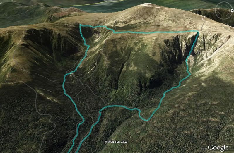
For me, my GPS has been a fun gadget, and with it I can make take tracks of a day and put them to Google Earth images and make cool things like this (thanks to MichaelJ for enlightening me to this!):

Googletrack.jpg
 
Last edited:

MichaelJ

Moderator
Moderator
Joined
Sep 16, 2002
Messages
2,349
Points
0
Location
The Watch City
Website
www.saletnik.org
Heh-heh. Great image!

One word of advice on the Garmins ... avoid the 70CS. If you want that model/feature set, go up to the 70CSx. They don't just differ by the presence of the expansion card; they actually have distinctly different chipsets and the difference is enormous. Una_dogger has a 70CS, I have the 70CSx, and I get a lock faster, get a smoother track, and in many places I get a signal lock and she has nothing at all.
 

cbcbd

New member
Joined
Sep 30, 2004
Messages
1,720
Points
0
Location
Seattle,WA
Another reminder... if you want to load maps into a mapping GPS, the maps are bought separately.

Another note... just because a GPS device doesn't have mapping it doesn't mean you can't load your track points into the PC with maps loaded and look at your track on a map. Out of the field, back home on the PC, you can do a lot with just GPS track points and some software. Mapping is nice to have if you're going to use maps out on the field. IMO, mapping is nice to have.
 

Crankfire

New member
Joined
Jun 24, 2008
Messages
34
Points
0
Location
Burlington, CT
Website
www.crankfire.com
Check out the Delorme PN20... it has raster basemap capabilities and I have heard all sorts of good things about them. The only testimony I can give for one is this: I have a Magellan Triton 500 - which lends one the ability to upload only USGS raster topographic basemaps... and apart from the unit suffering from all sorts of firmware issues, flakiness, and general POS syndrome, the raster map feature is amazing.

The vector basemaps you can get for the garmins and magellans are pretty much trash, especially in comparison! It does not get any better if you are trying to navigate through the woods.

Though Garmins are always a good choice. Solid stuff, good customer support. Their 60CSX is stuff of legends. I have not really checked out their new colorado one yet though. Looks funky.
 

GeoMan

New member
Joined
Jun 25, 2008
Messages
3
Points
0
So what do you recommend?

My all time favorite Garmin handheld GPS is the 60CSx. I have extensively used it and the Vista HCx which are very similar in terms of their specifications. They both do the same things, the 60CSx is just easier.

The Edge is really best used as a cycling tool. Alas, we've sold over 7,000 of the Edge 305's and customers really love them. Personally, I have over 300 MTB rides and several thousand miles logged on my Edge. I can't leave home without it. It is a critical element to collecting my ride metrics. My first year using the Edge, I lost 28 pounds. It provided feedback which I challenged myself with. For instance, you can race a course against your prior time.

Hope that helps. Looks like a great forum!

Thanks!
 

andyzee

New member
Joined
Sep 14, 2004
Messages
10,884
Points
0
Location
Home
Website
www.nsmountainsports.com
My all time favorite Garmin handheld GPS is the 60CSx. I have extensively used it and the Vista HCx which are very similar in terms of their specifications. They both do the same things, the 60CSx is just easier.

The Edge is really best used as a cycling tool. Alas, we've sold over 7,000 of the Edge 305's and customers really love them. Personally, I have over 300 MTB rides and several thousand miles logged on my Edge. I can't leave home without it. It is a critical element to collecting my ride metrics. My first year using the Edge, I lost 28 pounds. It provided feedback which I challenged myself with. For instance, you can race a course against your prior time.

Hope that helps. Looks like a great forum!

Thanks!


Like I mentioned in my first post, the Vista seems to loose connectivity to easy in the woods, do you think the 60CSx is better in terms of signal strength?
 

MichaelJ

Moderator
Moderator
Joined
Sep 16, 2002
Messages
2,349
Points
0
Location
The Watch City
Website
www.saletnik.org
Like I mentioned in my first post, the Vista seems to loose connectivity to easy in the woods, do you think the 60CSx is better in terms of signal strength?

The 60CSx does an awesome job with signal strength. I always get a good lock at the start and I virtually never lose it. I've gotten wobbly in deep ravines (as evidenced by wavering tracks) but that's about it.
 

GeoMan

New member
Joined
Jun 25, 2008
Messages
3
Points
0
The 60CSx does an awesome job with signal strength. I always get a good lock at the start and I virtually never lose it. I've gotten wobbly in deep ravines (as evidenced by wavering tracks) but that's about it.

Agreed.

The quad-helix antenna and the high sensitivity chipset on the 60CSx make for a flawless handheld as good as any.

Reception is the single most important aspect of a GPS. If you can't receive signals, you're hosed no matter what. That's where the 60CSX excels.

I've used handhelds since the early 90's. There were times when I threw them in frustration. No more.

Enjoy!
 

Crankfire

New member
Joined
Jun 24, 2008
Messages
34
Points
0
Location
Burlington, CT
Website
www.crankfire.com
Figure I would chime in real quick again...

I also have an Edge 205 (sigh... I own 11 handhelds) and Geoman is right, they are very very cool little devices. Very accurate - I use it as my primary for mapping trails - however, it is built to be a training device more than a navigation device. Overall... sure you can navigate with it, it's just not nearly as nav-centric as the 60csx or most any other handheld out there.
 

ski_resort_observer

Active member
Joined
Dec 26, 2004
Messages
3,423
Points
38
Location
Waitsfield,Vt
Website
www.firstlightphotographics.com
I don't think a GPS in regards to rural areas are very accurate and can even kill you. Just one example....this past winter a bus group coming up to the Bush from Boston ended up on Roxbury Gap, almost went over the side but luckily just ended up getting stuck. When we asked why the bus driver went that way, it's clearly marked as a dirt road on any map, and he advised he used a GPS for directions and thats where it told him to go.

I don't have one so I would be curious for those that have a GPS that if they plug in driving from Stowe to Jeffersonville will your GPS send you over Smugglers Notch. From Warren to Lincoln does it send you over Lincoln Gap and from Boston to Warren does it send you over Roxbury Gap.

Perhaps it's the GPS......I was thinking some would know not to send you over a road which is closed in the winter some will not. From what I have heard they work great in urban/suburban areas.
 
Top