• Welcome to AlpineZone, the largest online community of skiers and snowboarders in the Northeast!

    You may have to REGISTER before you can post. Registering is FREE, gets rid of the majority of advertisements, and lets you participate in giveaways and other AlpineZone events!

2/7-2/9

bheemsoth

New member
Joined
Dec 10, 2009
Messages
198
Points
0
Location
West Hartford, CT
Is it time to start discussing this as a potentially significant event? Looks like 3 of the 4 major models are in agreement, but I will defer to the experts for more analysis.


Sent from Samsung Galaxy S3 using Tapatalk 2
 

Puck it

Well-known member
Joined
Oct 26, 2006
Messages
9,691
Points
48
Location
Franconia, NH
Stop!!!!!!! I think we should just not talk about these anymore. Let's just let them happen. Just do not what to get to our hope up.
 

BenedictGomez

Well-known member
Joined
Jan 26, 2011
Messages
12,170
Points
113
Location
Wasatch Back
If you look at the models, I think it's going to slide too far to the east to have much of an impact, but at least everyone (other than Poconos) would get some snow. Would be good for ME though. Hopefully the models are wrong and this thing kicks west a bit. It's not like the models have been handling these storms well, so who knows. Think Snow!
 

Cornhead

Well-known member
Joined
Dec 4, 2010
Messages
2,839
Points
48
PLEASE BE SO!

I'm leaving for NH, and ME, early Thursday Morning, looks like the models have shifted South, but still in NE. Hope I didn't jinx myself.

:snow::snow::snow::snow::snow:


BenedictGomez

Well-known member
Joined
Jan 26, 2011
Messages
12,170
Points
113
Location
Wasatch Back
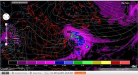
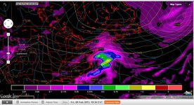
A little better still with this Euro run.

Maybe the storm is listening to me. Yo storm? KEEP coming WEST! West I said!!!!!

57546751035555567470212.png
 

billski

Active member
Joined
Feb 22, 2005
Messages
16,207
Points
38
Location
North Reading, Mass.
Website
ski.iabsi.com
Dammit. You guys have not had any ski/board pyre sacrifices to Ullr this season. What did you expect!

BTW, I'm going to be in NVT this F/S. I'm in good with Ullr. 6-7" in the last two days. You have been warned.
 

BenedictGomez

Well-known member
Joined
Jan 26, 2011
Messages
12,170
Points
113
Location
Wasatch Back
Isn't that Tuesday?

No; that snapshot in time is Saturday morning. The Euro has beantown getting clobbered with a blizzard.

BTW, I'm going to be in NVT this F/S. I'm in good with Ullr. 6-7" in the last two days. You have been warned.

If that model verifies, you might want to consider Magic, the 9" on that map could lead to even more with elevation. Of course, it's not like Smuggs or Jay would suck with 6" or 7".
 

WinnChill

New member
Joined
Nov 13, 2009
Messages
921
Points
0
I'm hoping so. Summit weekend? Fresh powder? That would be insanely awesome. Fingers crossed.

The Summit forecast "grade" could be bumped up to an A...ME and S NH would be most favored by this but this has big time whiff potential too, so I'm not doing cartwheels just yet.
 

4aprice

Well-known member
Joined
Mar 14, 2008
Messages
3,904
Points
63
Location
Lake Hopatcong, NJ and Granby Co
The Summit forecast "grade" could be bumped up to an A...ME and S NH would be most favored by this but this has big time whiff potential too, so I'm not doing cartwheels just yet.

Caution is definately the word, but this one has the weather boys over at Americanwx yelping. I still think the best is yet to come for this season from the Pocono's northward.


Alex

Lake Hopatcong, NJ
 

WinnChill

New member
Joined
Nov 13, 2009
Messages
921
Points
0
Caution is definately the word, but this one has the weather boys over at Americanwx yelping. I still think the best is yet to come for this season from the Pocono's northward.
Alex

Lake Hopatcong, NJ

I tend to agree that Feb works better for us. Conditions across the Pacific translate to more favorable conditions for east coast storms--sort of what we had at the beginning of the season. With this storm in particular, I worry about the lack of downstream blocking to keep the track close as this could easily slip right out to sea. But hey, at least it's something to get excited about, right? :)
 
Joined
Sep 15, 2012
Messages
780
Points
16
Location
Boston
No matter what we are still going to get 3-6 inches of snow at the minumum. Even if the storm goes out to sea on Friday night, the strong clipper moving through on Friday will deliver snow.

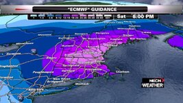
eurosnow.jpg

Wow, this would be one helluva storm if this pans out.
 

billski

Active member
Joined
Feb 22, 2005
Messages
16,207
Points
38
Location
North Reading, Mass.
Website
ski.iabsi.com
Hazardous weather outlook national weather service taunton ma 414 pm est tue feb 5 2013

this hazardous weather outlook is for northern connecticut...central massachusetts...eastern massachusetts...northeastern massachusetts...southeastern massachusetts...western massachusetts...southern new hampshire...northern rhode island and southern rhode island. .d

.days two through seven...wednesday through monday. Confidence continues to increase in the potential for a very significant winter storm friday into early saturday. While light snow may have developed friday morning...the worst of the storm looks to occur friday afternoon into early saturday. The exact details of the storm remain uncertain since the event is still 72 hours in the future. However...there is the potential for a foot or more of snow in some locations. The main uncertainty at this point is how far west the heaviest snow will reach into the distant interior. The other concern is will there be any mixing along the coastal plain that would cut down on potential snow accumulations.
 
Top