billski
Active member

Welcome to AlpineZone, the largest online community of skiers and snowboarders in the Northeast!
You may have to REGISTER before you can post. Registering is FREE, gets rid of the majority of advertisements, and lets you participate in giveaways and other AlpineZone events!


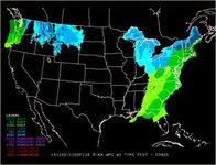
IF this thing even happens...
Thinking of a similar mid-December system last year where it was in the teens to start and then 6-12" later ended as freezing drizzle and in the mid 30s. The bulk of the precip looks to fall in the Saturday afternoon-night window when it will be mid 20s or so. The accumulating stuff should really shut down prior to above freezing temps.