billski
Active member
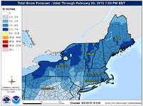
Wx wonks see signs of an active system coming through Thursday and Friday. Time for a thread.
It's almost getting unnecessary to track these things. Good riddance January! Go for it.
NATIONAL WEATHER SERVICE TAUNTON MA
357 PM EST MON FEB 2 2015
WEDNESDAY NIGHT INTO FRIDAY...LOW CONFIDENCE.
LARGE AREA OF UNCERTAINTY IN THIS PORTION OF THE FORECAST. AMERICAN
MODELS HAVE SIDED WITH THE GFS RESULTING IN A FRONT PUSHING THROUGH
THE REGION WEDNESDAY NIGHT INTO THURSDAY. EXPECT PRECIP TO DEVELOP
ALONG AS WELL AS BEHIND THE FRONT IN MORE OF AN ANA-FRONTAL SYSTEM.
THE EC AND UKMET HOWEVER SHOW A MIDWEST LOW MOVING THROUGH THE
NORTHEAST AND SOUTH OF NANTUCKET DEEPENING OUT INTO THE MARITIMES.
REGARDLESS BOTH OF THESE SYSTEMS SHOW PRECIP MOVING IN DURING THIS
TIMEFRAME. HOW IT FORMS AND THE EXACT TIMING IS STILL UNCERTAIN BUT
AM CONCERN THAT THE EC ENSEMBLES SHOW GOOD SUPPORT IN A COASTAL
REDEVELOPMENT ON THURSDAY INTO FRIDAY. HAVE INCREASED POPS BUT DID
NOT BUMP UP TO LIKELY DUE TO LARGE UNCERTAINTY ON TIMING. HOPEFULLY
GUIDANCE COMES IN BETTER AGREEMENT AS WE COULD POTENTIALLY SEE MORE
SNOW...AND ICE ACCUMULATIONS...ALSO ANOTHER ROUND OF WIND CHILL ADV
FOR THE COLD SURGE MOVING IN BEHIND THE FRONT/SYSTEM.
SATURDAY...MODERATE CONFIDENCE.
WEAK CLIPPER/LOW PRESSURE SYSTEM WILL MOVE THROUGH THE FLOW ON
SATURDAY. THIS MAY SPOUT OFF MORE SNOW SHOWERS FOR THE REGION. NOT
EXPECTING MUCH IN THE WAY OF ACCUMULATIONS. HOWEVER ON THE BACKSIDE
OF THIS SYSTEM COULD SEE REINFORCING COLD AIR SURGE INTO THE REGION.
SUNDAY INTO MONDAY...LOW CONFIDENCE.