• Welcome to AlpineZone, the largest online community of skiers and snowboarders in the Northeast!

    You may have to REGISTER before you can post. Registering is FREE, gets rid of the majority of advertisements, and lets you participate in giveaways and other AlpineZone events!

NWS 2016 / 2017 Winter forecast!

cm0311

New member
Joined
Feb 25, 2017
Messages
29
Points
0
Not one for a pissing contest but please name the met from accuweather and the model. I am not a met, just a hobby of mine but my understanding is that the energies will not be fully sampled until tonight's 0z. Anybody, claiming to know the outcome is misrepresenting educated opinion as fact. Oh and as if it mattered, my bsme is somewhere in the attic or maybe the basement, next to my masters degree.

Haha yes we are all engineers now. Have a nice day.

I know how big my dick is, I don't need to see how far I can piss too.
 

BenedictGomez

Well-known member
Joined
Jan 26, 2011
Messages
12,170
Points
113
Location
Wasatch Back
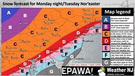
Sweet clown maps. Too bad it is exiting stage right.

Still 72 hours out and the systems are not even on our continent, a shit load can happen. Majority of EURO ensembles put it west of the forecast, trash the 12z run. Ukie kept it west. I'm still planning on driving up Tuesday am.

That's a heckuva sentiment shift in < 1 hour!
 

BenedictGomez

Well-known member
Joined
Jan 26, 2011
Messages
12,170
Points
113
Location
Wasatch Back
Was just speaking to a meteorologist from Accuweather who said models are showing it moving further east.
When I asked him what that meant for the White Mountains he mentioned more snow unless it tracks too Far East.

That is definitely not true at all, so it's weird an actual met from Accuweather would say that.

The GFS came east, but it was the western outlier, so that's pretty much meaningless.

The Canadian went well west.

The Euro slightly ticked east, but so little that it's not even worth calling an east or west or north or south shift.
 

cm0311

New member
Joined
Feb 25, 2017
Messages
29
Points
0
That is definitely not true at all, so it's weird an actual met from Accuweather would say that.

The GFS came east, but it was the western outlier, so that's pretty much meaningless.

The Canadian went well west.

The Euro slightly ticked east, but so little that it's not even worth calling an east or west or north or south shift.

Little disappointed eastern areas and seacoast due for jackpot. Rather see it up in ski country.

Better then nothing though that is for sure!
 

BenedictGomez

Well-known member
Joined
Jan 26, 2011
Messages
12,170
Points
113
Location
Wasatch Back
Little disappointed eastern areas and seacoast due for jackpot. Rather see it up in ski country.

Better then nothing though that is for sure!

Still a lot of time left and anything can happen as the energy isnt even over land yet. What you REALLY dont want to see is an eastern tick with the 00z tonight, that could be really bad news.
 

Kleetus

Member
Joined
Oct 6, 2013
Messages
327
Points
16
Location
Baldwinsville, Ny
Well big eastern tick with the 00Z GFS tonight. Maybe 6-10 for VT if that. Maybe the ECMWF is better?? I hope so cause not looking good in the GFS right now. Some snow is better than none, but big swing from what it had been showing so far.


Sent from my iPhone using AlpineZone
 

cm0311

New member
Joined
Feb 25, 2017
Messages
29
Points
0
Well big eastern tick with the 00Z GFS tonight. Maybe 6-10 for VT if that. Maybe the ECMWF is better?? I hope so cause not looking good in the GFS right now. Some snow is better than none, but big swing from what it had been showing so far.


Sent from my iPhone using AlpineZone

Sunday River is in the jackpot. Even more than the white mountains.
 

BenedictGomez

Well-known member
Joined
Jan 26, 2011
Messages
12,170
Points
113
Location
Wasatch Back
The 00z Euro just spat out a solution that, if it's correct would be an absolutely historic snowstorm.

Not in terms of huge amounts of snow in any given area, but in terms of a large snowfall over a positively massive area, as in >= 10" from Virginia to Quebec = WOW.
 

Tin

Active member
Joined
Oct 14, 2009
Messages
2,996
Points
38
Location
ZooMass Slamherst
That's a heckuva sentiment shift in < 1 hour!


300px-Trolling_drawing.jpg
 

Tin

Active member
Joined
Oct 14, 2009
Messages
2,996
Points
38
Location
ZooMass Slamherst
As of now, higher heights in eastern Canada, more amped ridge, further west block = more liquid, slower, and more west this morning. We are getting inside 48 hours so time to go to meso models.

Deform bands looking to set up best in the Catskills, NW CT, Berks, and southern VT.

For those trying to ski Weds.

Sections of NY and CT could be looking at 3-4" per hour rates (possibly Feb 2013 type rates of 6" per hour+) for an extended time Tuesday afternoon. Get out Monday night or first thing Tuesday (before 8am) or youre screwed.

Shit goes wild Tuesday afternoon for southern New England. Boston will be a nightmare by Tuesday evening, probably about 6" down and absolutely cranking 1-2" per hour rates+. Wind along the shore looking to be 50+. Legit blizzard

The wrap around is going to crank up and down the spine for days following. Would not be shocked to see everyone from K north grab an extra 12"+ between Weds night and Friday am. Could be one of those 4' weeks for Jay.

Forget skiing for a second. Heavy wet snow in CT, RI, and eastern Mass + this = disaster (NAM maybe a bit over modeled but this is also in knots)

925wh.us_ne.png


925wh.us_ne.png
 
Last edited:

powhunter

Active member
Joined
Mar 24, 2007
Messages
3,183
Points
36
Location
Southington Ct
As of now, higher heights in eastern Canada, more amped ridge, further west block = more liquid, slower, and more west this morning. We are getting inside 48 hours so time to go to meso models.

Deform bands looking to set up best in the Catskills, NW CT, Berks, and southern VT.

For those trying to ski Weds.

Sections of NY and CT could be looking at 3-4" per hour rates (possibly Feb 2013 type rates of 6" per hour+) for an extended time Tuesday afternoon. Get out Monday night or first thing Tuesday (before 8am) or youre screwed.

Shit goes wild Tuesday afternoon for southern New England. Boston will be a nightmare by Tuesday evening, probably about 6" down and absolutely cranking 1-2" per hour rates+. Wind along the shore looking to be 50+. Legit blizzard

The wrap around is going to crank up and down the spine for days following. Would not be shocked to see everyone from K north grab an extra 12"+ between Weds night and Friday am. Could be one of those 4' weeks for Jay.

Forget skiing for a second. Heavy wet snow in CT, RI, and eastern Mass + this = disaster (NAM maybe a bit over modeled but this is also in knots)

925wh.us_ne.png


925wh.us_ne.png

So your saying the moguls at Sundown are going to be fucking epic?


Sent from my iPhone using Tapatalk
 

Tin

Active member
Joined
Oct 14, 2009
Messages
2,996
Points
38
Location
ZooMass Slamherst
I would be surprised if Sundown has power to run the lifts to be honest. The Nemo-like deform bands and winds that are going to hit CT (even NW CT) and Mass are going to be insane.

Given all the wind of the previous few days it has probably weakened some trees/limbs, then throw snow and more wind on and it could be bad.
 
Last edited:

Puck it

Well-known member
Joined
Oct 26, 2006
Messages
9,691
Points
48
Location
Franconia, NH
I would be surprised if Sundown has power to run the lifts to be honest. The Nemo-like deform bands and winds that are going to hit CT (even NW CT) and Mass are going to be insane.

Given all the wind of the previous few days it has probably weakened some trees/limbs, then throw snow and more wind on and it could be bad.
So you are saying there is a chance!
 

Savemeasammy

New member
Joined
Mar 20, 2013
Messages
2,538
Points
0
Location
S. NH
So your saying the moguls at Sundown are going to be fucking epic?


Sent from my iPhone using Tapatalk

Maybe those bumps they just seeded get completely buried? You need to be on duty during the storm to ski them to keep that from happening!


Sent from my iPhone using AlpineZone
 

BenedictGomez

Well-known member
Joined
Jan 26, 2011
Messages
12,170
Points
113
Location
Wasatch Back
Crazy thing about this storm is there was such perfect agreement with the models a few days ago, now that we're closer to the event, there's little agreement other than the fact there's going to be a big snowstorm. This is completely opposite from normal, as usually there's dispersion ahead of an event, and as the event nears the models tighten up.

Basically, regardless of where you live, if you want big snow, there's a map for that! There's also a model (or two) that will screw you.

At this moment, based on the confluence of models, if I were pressed, I'd guess Berks to s.VT to s.NH ski areas will be the biggest winners. Likewise, if pressed, I'd guess ADK is most likely to get screwed, followed by Jay Peak, but again, everyone gets some snow.
 
Top