• Welcome to AlpineZone, the largest online community of skiers and snowboarders in the Northeast!

    You may have to REGISTER before you can post. Registering is FREE, gets rid of the majority of advertisements, and lets you participate in giveaways and other AlpineZone events!

NWS 2016 / 2017 Winter forecast!

yeggous

Active member
Joined
Oct 8, 2012
Messages
2,170
Points
36
Location
Eagle, CO
First, thank you for spending the time on generating these links to the article. I read the Dyer et al paper on Spatial Variability and Trends... , the other paper, Onset of Spring starting earlier across the NH by Schwartz et al was paywalled so I just read the abstract. As for the latter, using the biological markers for spring detection is well known however spring is just one end of the snow season, what about the start? As for the former paper, the SCE was based on surface measurements so the sampling from these stations can result in questionable findings.

The Rutgers snow lab published fall, winter and spring snow SCE plots from 1967 to present, the link to these graphs are shown below. The plots do show SCE decreasing in spring while it has been increasing in both fall and winter.

http://climate.rutgers.edu/snowcover/chart_seasonal.php?ui_set=nhland&ui_season=1


The paper below uses the satellite data and shows the seasons are shifting as the plots above have shown. The paper concludes a net neutral effect. Of intetrest to me is what is causing this shift.

http://climate.rutgers.edu/stateclim_v1/robinson_pubs/refereed/Choi_Robinson_and_Kang_2010.pdf

Autumn changes are less clear. Evidence suggests the trend probably depends on the latitude, with warming and delayed autumn being greater at high latitudes:
doi:10.1111/j.1466-8238.2011.00675.x
But autumn in general shows high variability which masks the signal.

That paper by Choi et al. is consistent to other published work. They note a decrease in the length of "full snow season" but see no such trend in "core snow season". I've seen other work that agrees that the core of winter hasn't changed much yet but the tail seasons are a different story.

As for the cause of all this... getting at any definable cause in the highly coupled climate system is nearly impossible. Arctic sea surface temperatures / lack of sea ice is a obvious and tantalizing suspect.
doi:10.1038/nature09051
Of course as already discussed, the reduced sea ice is could also be playing a role in stabilizing our winter temperatures but weakening the polar vortex.
 

4aprice

Well-known member
Joined
Mar 14, 2008
Messages
3,904
Points
63
Location
Lake Hopatcong, NJ and Granby Co

slatham

Well-known member
Joined
Sep 17, 2012
Messages
2,433
Points
83
Location
LI/Bromley
Seems this year is the battle of the models vs. the analogs. Recent model runs warm (NNME, Euro, etc) but analogs cold. Pastelok and Bastardi staying the course, but looking at the models gives one pause (or at least nausea).

Oh, and next weeks storm on the 12Z GFS just went poof.......
 

mriceyman

New member
Joined
Jan 4, 2012
Messages
1,344
Points
0
Location
cnj
Seems this year is the battle of the models vs. the analogs. Recent model runs warm (NNME, Euro, etc) but analogs cold. Pastelok and Bastardi staying the course, but looking at the models gives one pause (or at least nausea).

Oh, and next weeks storm on the 12Z GFS just went poof.......

Youll see alot of nervous forecasters if the cold keeps getting pushed back. I really hope our december is cold


Sent from my iPhone using AlpineZone
 

dlague

Active member
Joined
Nov 7, 2012
Messages
8,792
Points
36
Location
CS, Colorado
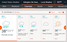
Well this could make things firm or soft for FIS if this happens according to accuweather!

forecastKillington.png
 

prsboogie

Active member
Joined
Aug 13, 2014
Messages
1,764
Points
38
Location
Swansea
It's funny I just looked at that exact forecast!


Sent from my iPhone using AlpineZone
 

jack97

New member
Joined
Mar 4, 2006
Messages
2,513
Points
0
Seems this year is the battle of the models vs. the analogs. Recent model runs warm (NNME, Euro, etc) but analogs cold. Pastelok and Bastardi staying the course, but looking at the models gives one pause (or at least nausea).

Oh, and next weeks storm on the 12Z GFS just went poof.......

Bastardi has been trashing the GFS for the past months, one of pet peeve is the models tele connections to various indices, his opinion is its in contradiction. Speaking of which, along with the analogs, Bastardi has factored the work from Cohen, the AO index and the fall snowpack. It appears Accuweather long range forecaster Sosnowski is on board with the mid Nov cold spell. Hearing this w/e cold shot is a short term event.

http://www.accuweather.com/en/weath...-turn-stormy-colder-snowy-eastern-us/61313612
 

yeggous

Active member
Joined
Oct 8, 2012
Messages
2,170
Points
36
Location
Eagle, CO
Two chances for snow next week. Both the GFS and Euro have "something" this weekend. Turkey Day could also be interesting.

Yes the promised late November pattern change is materializing in the models


Sent from my iPhone using AlpineZone mobile app
 

Jully

Active member
Joined
Dec 13, 2014
Messages
2,487
Points
38
Location
Boston, MA
When was the last time we had snow on Thanksgiving? It could be like... two years ago, but I think it has been awhile.
 

yeggous

Active member
Joined
Oct 8, 2012
Messages
2,170
Points
36
Location
Eagle, CO
When was the last time we had snow on Thanksgiving? It could be like... two years ago, but I think it has been awhile.

You mean on the ground in the mountains? Or actively falling from the sky in the flatlands?


Sent from my iPhone using AlpineZone mobile app
 
Top