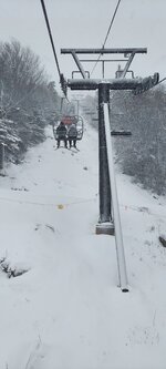
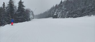
• Welcome to AlpineZone, the largest online community of skiers and snowboarders in the Northeast!

    You may have to REGISTER before you can post. Registering is FREE, gets rid of the majority of advertisements, and lets you participate in giveaways and other AlpineZone events!

Weekend storm thread....

tnt1234

Well-known member
Joined
Sep 12, 2014
Messages
1,492
Points
48
How we feeling?

Forecasts all over the place.

8" S.Vt at elevation?

14" N/VT

8" cats?

We believing this?

Seems like something of a nail biter with rain in the valleys.

I'm skiing Platty Sunday, and hiking in the cats Saturday, so curious to see what happens!
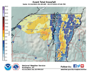
 

Dickc

Active member
Joined
Dec 5, 2013
Messages
567
Points
43
Location
Northeast Mass
Tim Kelly noted that this may be MORE NCP in Northern Vt, and more SNOW in Southern, VT. While he said that is unusual, it does happen at times. He indicated the two “jackpot” areas might be centered near Wilmington, VT, and North Conway, NH. Would really bail out Vail if North Conway gets a jackpot amount.
 

WWF-VT

Well-known member
Joined
Sep 23, 2005
Messages
2,598
Points
48
Location
MA & Fayston, VT
WCAX at 3 PM today

The storm will move in tonight just after midnight with snow, especially in the higher elevations, but the snow will mix with, and change to rain in the valleys by daybreak on Saturday. By Saturday afternoon, a surge of warmer air will move in aloft, changing the mountain snow to rain as well, but the precipitation will be tapering off to showers.

Winds will be gusty out of the ESE late Friday into mid-Saturday. Some gusts could be as high as 45 mph, especially along the western-facing slopes.

By the end of Saturday, cold air will start to come back in, changing the rain showers back to snow showers. Those snow showers will be persistent through Saturday night and Sunday, and they will be concentrating themselves more in the higher elevations.

By the end of the day on Sunday, the valleys will end up with only a trace to around 3″ of total snowfall. But as you get away from the Champlain Valley and into some of the higher elevations, you can expect 2-4″ of accumulation. The higher you go in elevation, the higher the snowfall totals will be . . . as much as 6-12″ in the mountains by the end of the weekend.
 

keyser soze

Member
Joined
Nov 16, 2008
Messages
282
Points
18
Wow, NWS shows 1 -2 feet of snow over the weekend at Killington,which is much needed. I will not miss booting up at the car in that wind and blowing snow though.
 

KustyTheKlown

Well-known member
Joined
Mar 1, 2013
Messages
5,405
Points
113
Location
Brooklyn
ya bolton has 18" by monday when you add up the high end of weather.gov forecasts. this should be a nice smacker at elevation. desperately needed. and then the 10 day looks great.
 

machski

Well-known member
Joined
Sep 5, 2014
Messages
3,721
Points
113
Location
Northwood, NH (Sunday River, ME)
Swinging colder and more snow at Sunday River. NWS has us in a wide 5-12" range and noted that below 1500', snow may have a tough time accumulating. Sounds very elevation dependant, much like the early December storm we had. This time they have all the high pods in play (Aurora, Oz, Jordan). Now, if the winds don't kill things.....
 

tnt1234

Well-known member
Joined
Sep 12, 2014
Messages
1,492
Points
48
About 4" of dense snow here at our shack which is about 2,400 feet. Still coming down, switching between rain and snow as we watch.
 

ScottySkis

Well-known member
Joined
Jan 16, 2011
Messages
12,294
Points
48
Location
Middletown NY
In west Catskill NY
Few miles between platty and bellflat:

""CURRENT CONDITIONS :

8 inches of snow and counting! The Friday night storm left us with plenty of snow to open for snow tubing/sledding, cross country skiing, snowshoeing, and fat tire biking this weekend (Saturday, January 16th - Monday, January 18th).

We are working to clear the Ice Skating ribbon and curling sheet. However, heavy snow rendered the ice surface un-skateable. Thus, ice skating will likely open tomorrow, Sunday, January 17th.

Send us a message or give us a call if you need any help with directions and road conditions. Drive safely!"
 

skimagic

Active member
Joined
Jan 13, 2012
Messages
361
Points
28
Location
Western New England
Looks like Stratton, Bromley, okemo and magic were in the 8 inch range according to snow reports. Thick, dense paste on the cams....

Catamount, 2".
 

slatham

Well-known member
Joined
Sep 17, 2012
Messages
2,439
Points
83
Location
LI/Bromley
From what I hear (not there right now) SoVT was 10” or so. Note that the graphics above from NWS yesterday includes the backside/upslope that should start later today and continue into Sunday afternoon. Hopefully that materializes but it as usual will be focused along he spine at elevation.

This dense snow is great base for natural trails. Looks like reasonable cold and frequent clippers could keep us in good skiing for a bit, fingers crossed.
 

Zand

Well-known member
Joined
Dec 30, 2003
Messages
4,129
Points
113
Location
Spencer, MA
Lots of big wind holds. Cannon is closed for the day. Not good on Saturday of a holiday weekend. But hopefully the kickoff of a good stretch.
 

drjeff

Well-known member
Joined
Jan 18, 2006
Messages
19,215
Points
113
Location
Brooklyn, CT
Looking at MT Snow web cam, they got close to a foot.
I can confirm that even after a little drizzle around noon, and some slight settling that the temp creaping up to 34 at my condo across route 100 from the mountain that there was still a foot on my deck for me to shovel off before grilling this evening!

Great base snow too. Definitely some density to it. Wouldn't surprise me if I heard that there was between 1.5 and 2" of water content in the snow that fell

And amazingly enough, the forecasted winds never (or atleast as of almost 3PM) materialized
 

thebigo

Well-known member
Joined
May 15, 2005
Messages
1,881
Points
113
Location
NH seacoast
Snowed heavy at wildcat all day, still snowing when I headed home mid afternoon. Did not want to leave but everything was soaked and frozen. Upper catapult rope dropped, sampled upper wildcat. I don't know the total but it was deep, NWS calling for another 11 - 17 this afternoon plus another 3 - 7 tomorrow. Would guess 2'+ when done, no rain.

Only wind was on the summit, surprised to hear cannon closed for wind.
 
Top