• Welcome to AlpineZone, the largest online community of skiers and snowboarders in the Northeast!

    You may have to REGISTER before you can post. Registering is FREE, gets rid of the majority of advertisements, and lets you participate in giveaways and other AlpineZone events!

Long Range Possibility

BodeMiller1

Well-known member
Joined
Mar 7, 2022
Messages
1,713
Points
63
Location
Barre, VT
Nice view from the top of Killington Peak this morning. No snow the top of Washington; looks a little warmer today. It's all coming together for a great start. The start to what? At this point we don't know. :cool::coffee: (y) or (n). The glass is always half full in Septober.

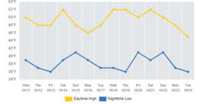
Jay Peak Vermont / 14 day high low temp/ All rights to The Weather Network.
 

Attachments

  • 0706d0c87dd15884f4794ed07b95b5f6dde7c43d.png
    0706d0c87dd15884f4794ed07b95b5f6dde7c43d.png
    613 bytes · Views: 4
  • download.png
    download.png
    33.2 KB · Views: 4

Abubob

Well-known member
Joined
Apr 9, 2010
Messages
3,533
Points
63
Location
Alexandria, NH
Website
tee.pub
Welp, snow on the backside of this weekend storm seems to have faded but GFS models still want snow sometime soon.

IMG_4022.png
 

BodeMiller1

Well-known member
Joined
Mar 7, 2022
Messages
1,713
Points
63
Location
Barre, VT
Warm peaks this Thursday, what goes down must go up - at least on The East Coast in November.
 

BodeMiller1

Well-known member
Joined
Mar 7, 2022
Messages
1,713
Points
63
Location
Barre, VT
Snow is nice butt ice is quicker. This storm is a perfect start to natural snow fall. It will end in ice / rain which is exactly what the doctor ordered in that the rain will make the snow stick to the slopes leaving steep trails coated in ice and snow...

Over two feet will fall on Mt Washington and the other mountains will get their fair share. You have no friends on Icey trails.

File under occluded front.

Don Kent Plymouth State College out.
 

BodeMiller1

Well-known member
Joined
Mar 7, 2022
Messages
1,713
Points
63
Location
Barre, VT
Hello, I'm sorry I lost my self, I think I thought you were someone else.:rolleyes:

.Occluded FrontA composite of two fronts, formed as a cold front overtakes a warm or quasi-stationary front. Two types of occlusions can form depending on the relative coldness of the air behind the cold front to the air ahead of the warm or stationary front. A cold occlusion results when the coldest air is behind the cold front and a warm occlusion results when the coldest air is ahead of the warm front

.Occluded MesocycloneA mesocyclone in which air from the rear-flank downdraft has completely enveloped the circulation at low levels, cutting off the inflow of warm unstable low-level air.


Should we talk about the government?
Should we talk about the weather?

Hey hey hey

All rights to R.E.M. and the NOAA weather station glossary grey Maine.

MEOW
 

Attachments

  • PeterBuck.jpg
    PeterBuck.jpg
    8.3 KB · Views: 1

BodeMiller1

Well-known member
Joined
Mar 7, 2022
Messages
1,713
Points
63
Location
Barre, VT
Two Lows tracking across the U.S. one clipper hits Northern New England. :snow:The second snow further South, bringing the "snow in my back yarders" to the slopes.

Perfect for the ski industry.

Meanwhile, a standalone ski area out West closes to cut losses. (n)
 
Top