• Welcome to AlpineZone, the largest online community of skiers and snowboarders in the Northeast!

    You may have to REGISTER before you can post. Registering is FREE, gets rid of the majority of advertisements, and lets you participate in giveaways and other AlpineZone events!

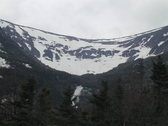
How's The Mt. Washington Cam Looking?

loafer89

New member
Joined
Apr 21, 2004
Messages
3,978
Points
0
Location
Enfield, C.T
Apparently Tuckerman took a severe beating with 4.5" of rain reported in todays avalanche report:

avalanche.jpg
 
Last edited:

andyzee

New member
Joined
Sep 14, 2004
Messages
10,884
Points
0
Location
Home
Website
www.nsmountainsports.com
Damn, that doesn't look good at all! For anyone that can't read the pic that Loafer89 put up, here's a cut and paste, thanks loafer89:


Tuckerman Ravine has LOW avalanche danger today. Natural avalanches are very unlikely and human triggered avalanches are unlikely except in isolated pockets. Normal caution is advised.
We are through issuing avalanche advisories for Huntington Ravine using the U.S 5 Scale Danger Rating System for the remainder of the season. A "General Advisory" is currently in effect. You will need to rely on your own snow stability assessments when using avalanche terrain in Huntington Ravine. There is a danger of falling ice and it will persist until it all comes down.
As you will see when you take a look at the pictures we put on tuckerman.org last night, 4 days of rain has absolutely hammered the Ravine and has made a substantial change in conditions. After receiving 4.5" (11.5cm) of rain we are once again at another new benchmark for conditions. Wipe any impression you had about snowcover and hazards that you saw in the Ravine before the rain and give it a brand new look with open eyes. Although ice still remains in a number of places around the Ravine, a tremendous amount has come smashing down to the floor of the Bowl. Crevasses have opened up all over and the right side under the Headwall, Lip, and Sluice have begun looking like the Khumbu icefield on Everest. The Lip has disintegrated into just an isolated patch of snow. Due to this THE LIP AND THE TUCKERMAN RAVINE TRAIL THRU THE RAVINE FROM LUNCH ROCKS ON THE FLOOR OF THE RAVINE TO THE JUNCTION WITH THE ALPINE GARDEN TRAIL JUST ABOVE THE HEADWALL IS CLOSED TO ALL USE. Only this section of the trail is closed. This section is closed annually due to the magnitude of crevasses and undermining that develop in this area during the spring melt-out. A fall in this area would have severe consequences. The Headwall is now bare and is a series of running waterfalls from the Lip over to the Chute. I know this sounds awful and I'm looking at the glass as half empty rather than half full, but as I look at the extended 7 day forecast, rain will dominate the period. Unfortunately things won't get any better. Well getting away from doom and gloom for a moment, Left gully currently offers the best alternative with the longest consistent skiing with the least objective mountain hazards. If you plan on visiting the Ravine, the Left side of the Ravine will give you the least exposure to icefall, crevasses, undermining and poor runnout. With that said, it still contains these problems but to a lesser degree. As you approach this area you will be in the runnout of the Headwall if falling ice does occur. Thick fog this morning will cause a problem for both seeing icefall and other hazards as well as making navigation difficult.
Anticipate slick travel conditions on the upper summit cone as freezing rain and some snow covered rocks during the afternoon yesterday. Rain and temperatures in the 30's will make for some conducive hypothermia conditions so if you do venture out make sure you have quality mountain clothing that is waterproof and leave the cotton at home. Expect flooding on trails and numerous undermined channels in the snow.
ICEFALL is still a concern. Many people have been hurt or killed by the mountain's springtime icefall. Although a great deal of ice has fallen this week a lot is yet to come. Chunks of ice the size of trucks may reach the floor of the Bowl so always have a good escape route planned and don't linger under exposed ice. The areas with the most potential for icefall are still the Sluice, which is directly above Lunch Rocks, and the Headwall. If you're spending time in one place try and make it on the downhill side of a big boulder that may act as some protection.
The John Sherburne Ski is closed for the season. The trail is not designed for foot traffic and is currently very wet and muddy. Please walk down the Tuckerman Ravine Trail from Hermit Lake. THE LION HEAD SUMMER TRAIL IS OPEN. Some steep snowfield traverses exist as you break above treeline. These may make a bed surface for potential avalanches if we receive late season snow. You will need to do your own assessment of the stability before crossing these slopes. They are also very steep so an ice axe and crampons are required to safely traverse this area.
 

loafer89

New member
Joined
Apr 21, 2004
Messages
3,978
Points
0
Location
Enfield, C.T
Sorry that the picture was too small, it's bigger now but andyzee did a better job.:p

NOAA forecasts's another 1.0" + of rain between now and tuesday, and unsettled weather for the next 7 days.
 
Last edited:

riverc0il

New member
Joined
Jul 10, 2001
Messages
13,039
Points
0
Location
Ashland, NH
Website
www.thesnowway.com
ouch. hopefully things will dry up before next weekend. plenty of turns still to be made in chute and left gully. maybe right holding onto limited amounts of snow. that is a lot of doom and gloom.
 
Top