MidnightJester
Well-known member
- Joined
- Oct 7, 2011
- Messages
- 1,076
- Points
- 83
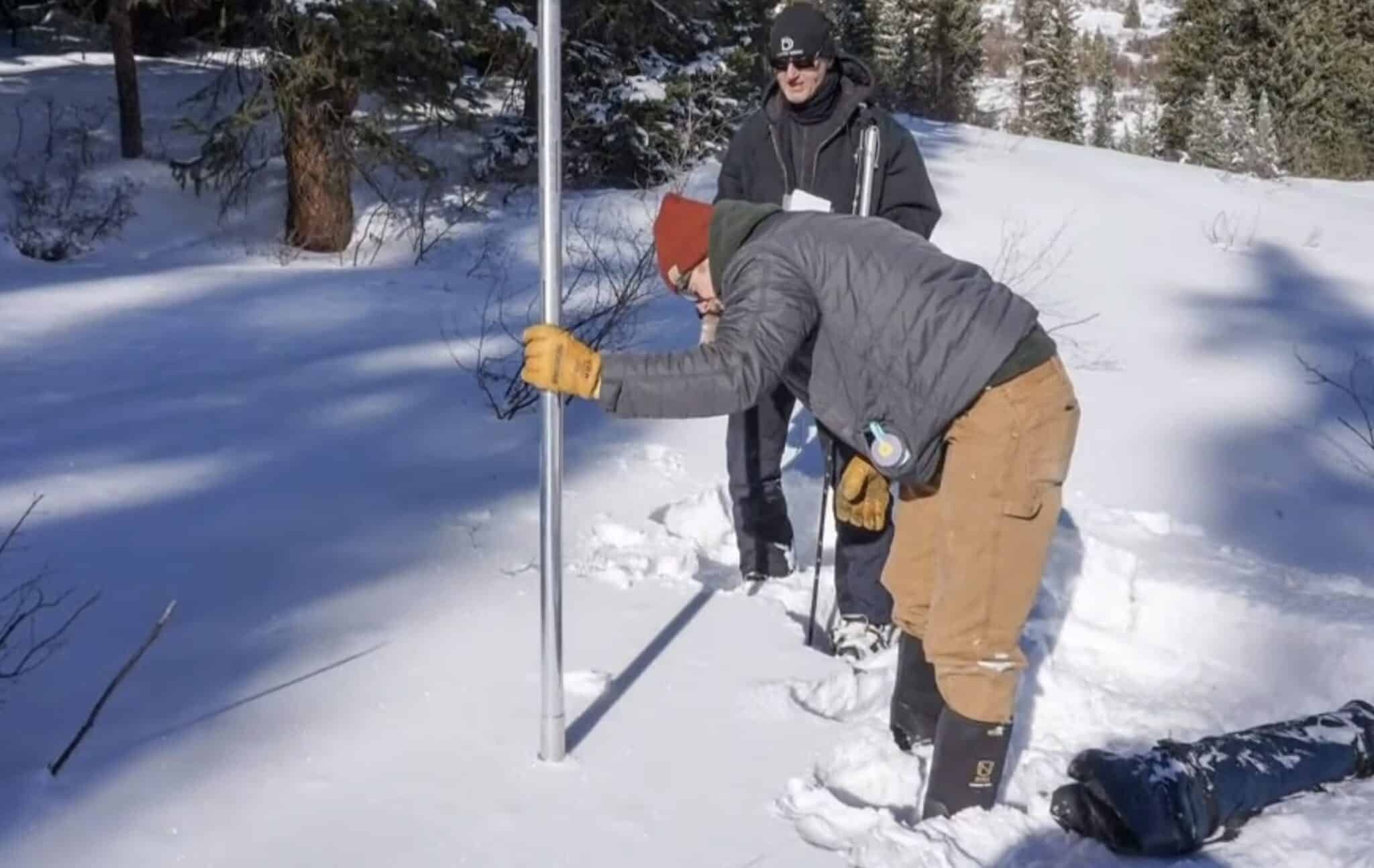
This is the current state of the some of the Ski mountains we love and hate and their open trail counts and the Snow totals for their season to date
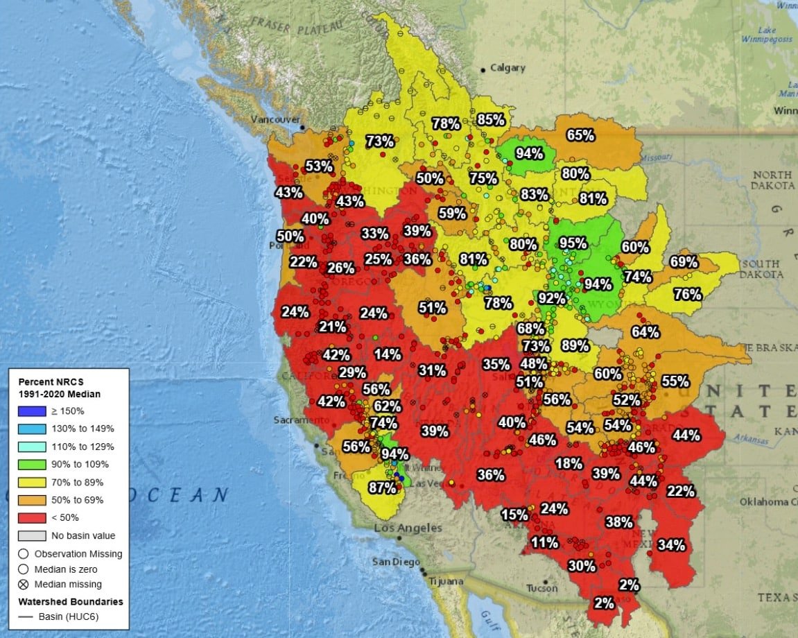
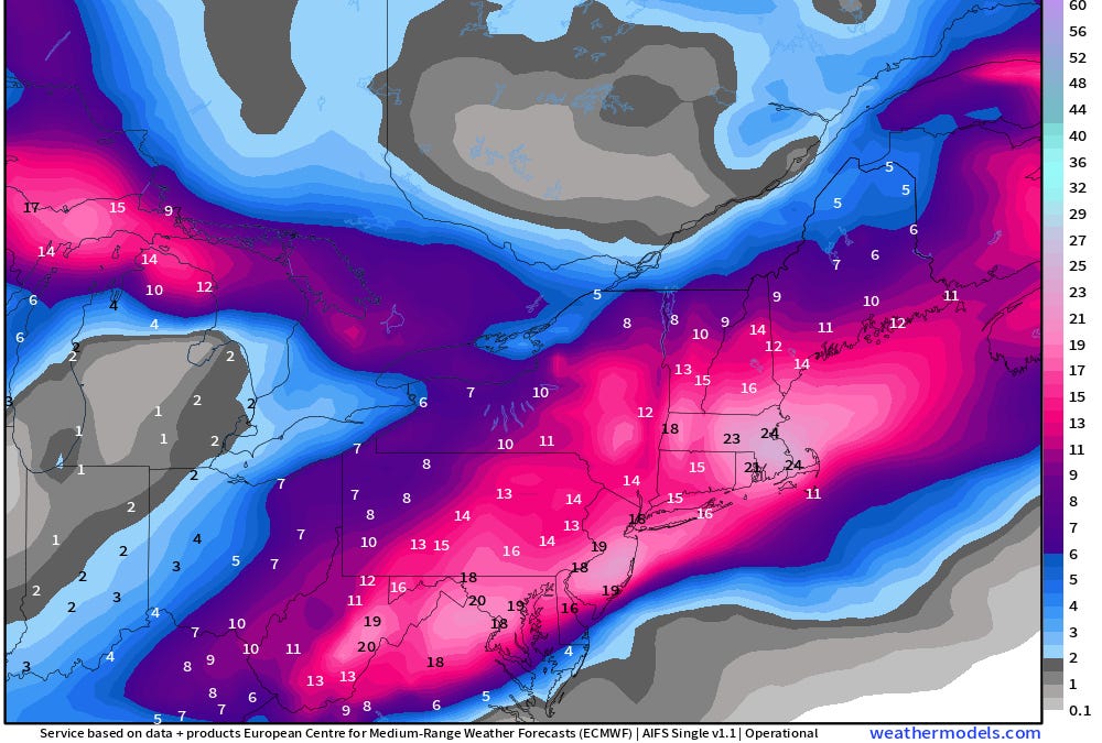
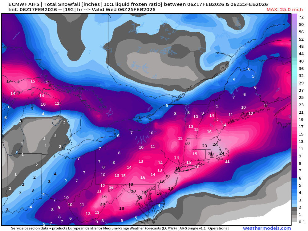
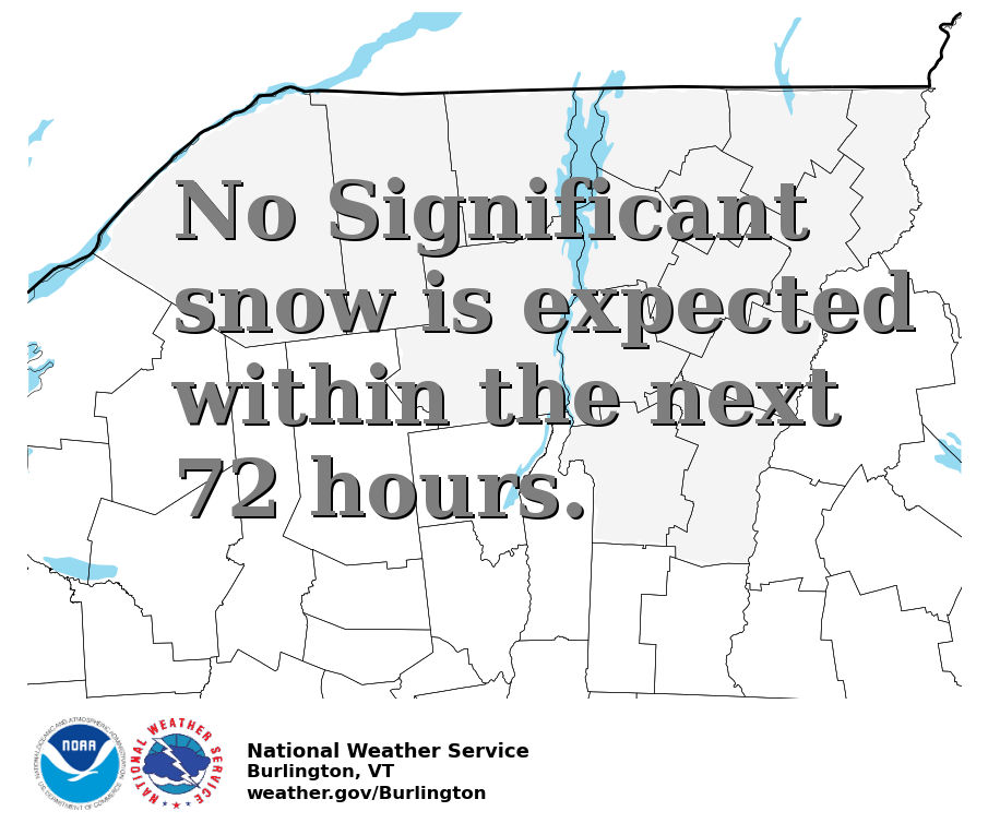
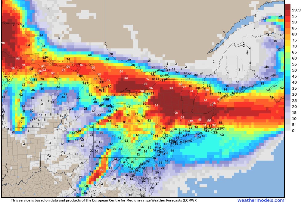
The fast Winter recap is its the Worst start for and the worst Year to date(1st half) for most of the US Western states and Larger snow totals for most of BC Canada, US East and Upper VT especially. The Northeast has been having the year or years (2 in a row) for persistent COLD and near record SNOW levels again for Mt. Mansfield and JAY PEAK!
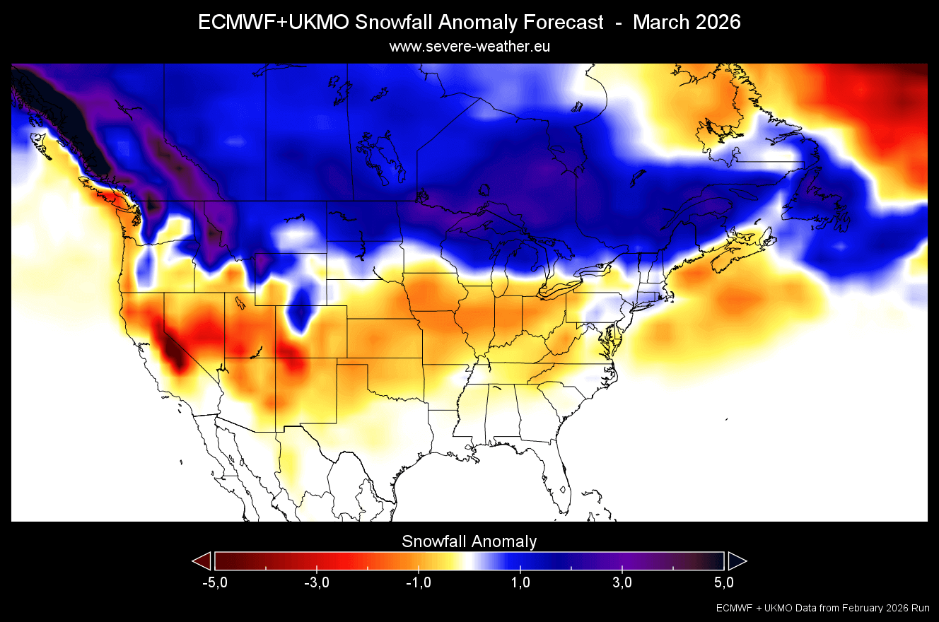
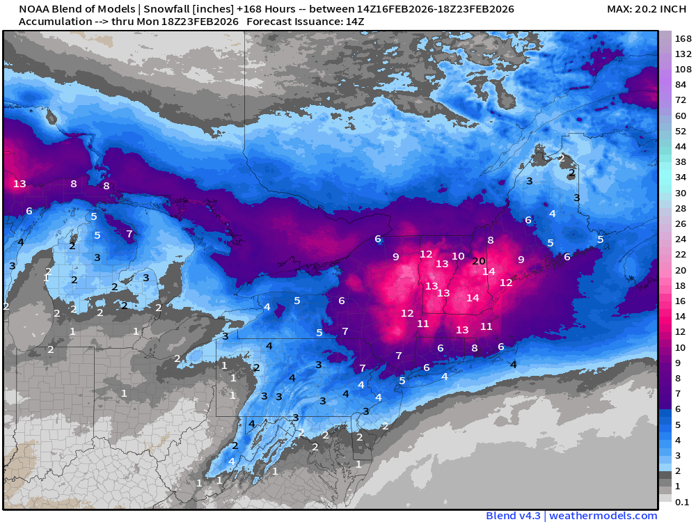
So we are past midway into the 2025/2026 ski season and Winter snow is finally on the way for most of the country all at the same time. The US Wests SNOW prayers are doing something and it looks like the Northeast and VT have a Midweek Foot possible. Let the Fresh powder fall and Snow lovers rejoice in celebration for the 2026 Winter Olympics. Bring on the SNOW. "ULLR, ULLR, ULLR"
~~~~Northeast Shoutout~~~~
Monday 2/9/26 (Open trail counts & Season snow totals)
Mount Snow, VT -- 82/86 -- 90"season total
Stratton, VT -- 94/99 -- 111" season total
Magic Mountain, VT -- --/50 -- 75" season total
Okemo, VT -- 121/129 -- 86" season total
Killington Resort, VT -- 154/155 -- 149" season total
Sugarbush, VT -- 109/111 -- 166" season total
Mad River Glen -- 60/60 (FULLY OPEN) -- 143" season total
Bolton Valley, VT --55/71 -- 235" season total
Stowe, VT -- 108/127 -- 231" season total
Smugglers Notch, VT -- 74/78 -- 235" season total
Jay Peak, VT -- 82/82 (FULLY OPEN) & (322" SEASON SNOWFALL TOTAL)
--------------------------------------------
Belleayre, NY -- 62/62 -- 80" season total
Gore Mountain, NY -- 76/111 -- 69" season total
Hunter Mountain, NY -- 59/66 -- 67" season total
Windham, NY -- 52/54 -- (NO SNOW TOTALS)
Whiteface Mountain, NY -- 88/94 -- 160" season total (RARELY THIS OPEN)
------------------------------------------
Sunday River, ME -- 132/139 -- 82" season total
Sugarloaf, ME -- 150/170 -- 89" season total
Saddleback, ME -- 68/68 -- 129" season total
-------------------------------------------
Wildcat ,NH -- 43/48 -- 80" season total (TRAILS ARE OPENING)
Attitash, NH -- 68/76 -- 58" season total
Loon Mountain, NH -- 73/73 -- NO SEASON TOTAL
Mount Sunapee, NH -- 63/67 -- 42" season total
Cannon, NH -- 37/97 --> 97/97 -- 144" season total
Bretton Woods, NH -- 100/100 -- 122"season total (FULLY OPEN)
-------------Out West-------------
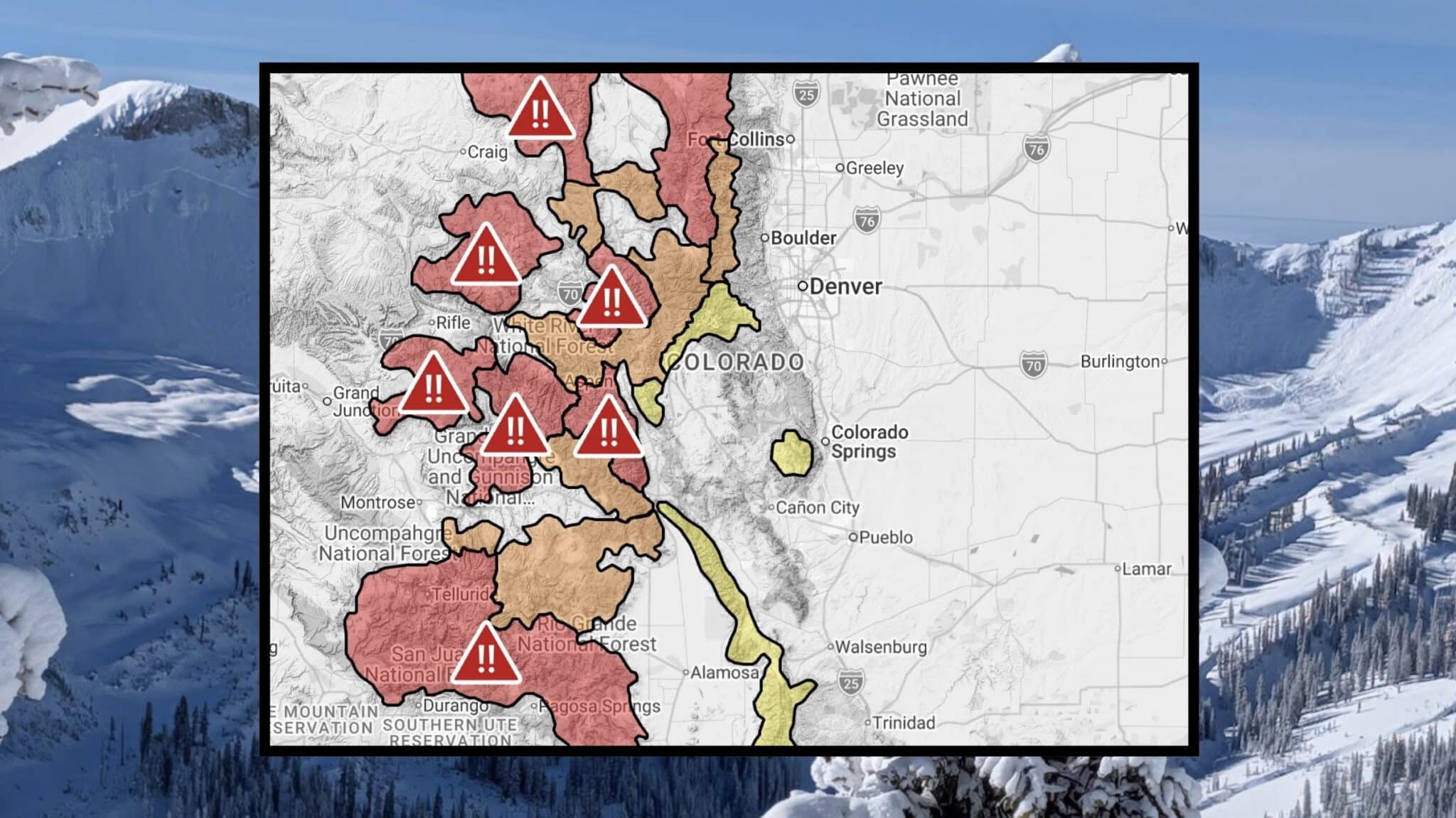
Breckenridge, CO -- 110/192 -- 83" Season total
Vail, CO -- 189/277 -- 90" Season total
Aspen Snowmass, CO -- 315/366 (4-mountains)
Winter Park Resort, -- CO 99/171 -- 113" Season total
Beaver Creek, CO -- 77/176 -- 73" Season total
Keystone Resort, CO -- 105/143 -- 90" Season total
Steamboat, CO -- 163/184 -- 101" Season total (FULLY OPEN)
Telluride, CO -- 127/147 -- 70" Season total
Arapahoe Basin, CO -- 31/145 -- (NO SNOW TOTALS)
Loveland, CO -- 58/94 -- 99" Season total
Wolf Creek, CO -- 144/144 -- 94" Season total (FULLY OPEN)
----------------------------------------
Mammoth Mountain, CA -- 170/178 -- 156" Season total
----------Lake Tahoe CA,NV---------
Kirkwood, CA --84/84 -- 161" Season total (FULLY OPEN)
Northstar California, CA --92/100 -- 156" Season total
Palisades Tahoe, CA -- 211/270 -- 154" Season total
Heavenly CA,NV -- 111/111 -- 114" Season total (FULLY OPEN)
Mt. Rose - Ski Tahoe, NV -- 67/67 -- 152" Season total
-----------------------------------------
Solitude, UT -- 72/82 -- 131" Season total
Park City, UT -- 204/346 -- 85" Season total
Alta, UT -- 110/118 -- 143" Season total
Deer Valley, UT -- 136/123 -- 85" Season total
Snowbasin , UT -- 69/115 -- 74" Season total
Snowbird, UT -- 142/149 -- 137" Season total
The fast Winter recap is its the Worst start for and the worst Year to date(1st half) for most of the US Western states and Larger snow totals for most of BC Canada, US East and Upper VT especially. The Northeast has been having the year or years (2 in a row) for persistent COLD and near record SNOW levels again for Mt. Mansfield and JAY PEAK!
So we are past midway into the 2025/2026 ski season and Winter snow is finally on the way for most of the country all at the same time. The US Wests SNOW prayers are doing something and it looks like the Northeast and VT have a Midweek Foot possible. Let the Fresh powder fall and Snow lovers rejoice in celebration for the 2026 Winter Olympics. Bring on the SNOW. "ULLR, ULLR, ULLR"
~~~~Northeast Shoutout~~~~
Monday 2/9/26 (Open trail counts & Season snow totals)
Mount Snow, VT -- 82/86 -- 90"season total
Stratton, VT -- 94/99 -- 111" season total
Magic Mountain, VT -- --/50 -- 75" season total
Okemo, VT -- 121/129 -- 86" season total
Killington Resort, VT -- 154/155 -- 149" season total
Sugarbush, VT -- 109/111 -- 166" season total
Mad River Glen -- 60/60 (FULLY OPEN) -- 143" season total
Bolton Valley, VT --55/71 -- 235" season total
Stowe, VT -- 108/127 -- 231" season total
Smugglers Notch, VT -- 74/78 -- 235" season total
Jay Peak, VT -- 82/82 (FULLY OPEN) & (322" SEASON SNOWFALL TOTAL)
--------------------------------------------
Belleayre, NY -- 62/62 -- 80" season total
Gore Mountain, NY -- 76/111 -- 69" season total
Hunter Mountain, NY -- 59/66 -- 67" season total
Windham, NY -- 52/54 -- (NO SNOW TOTALS)
Whiteface Mountain, NY -- 88/94 -- 160" season total (RARELY THIS OPEN)
------------------------------------------
Sunday River, ME -- 132/139 -- 82" season total
Sugarloaf, ME -- 150/170 -- 89" season total
Saddleback, ME -- 68/68 -- 129" season total
-------------------------------------------
Wildcat ,NH -- 43/48 -- 80" season total (TRAILS ARE OPENING)
Attitash, NH -- 68/76 -- 58" season total
Loon Mountain, NH -- 73/73 -- NO SEASON TOTAL
Mount Sunapee, NH -- 63/67 -- 42" season total
Cannon, NH -- 37/97 --> 97/97 -- 144" season total
Bretton Woods, NH -- 100/100 -- 122"season total (FULLY OPEN)
-------------Out West-------------
Breckenridge, CO -- 110/192 -- 83" Season total
Vail, CO -- 189/277 -- 90" Season total
Aspen Snowmass, CO -- 315/366 (4-mountains)
Winter Park Resort, -- CO 99/171 -- 113" Season total
Beaver Creek, CO -- 77/176 -- 73" Season total
Keystone Resort, CO -- 105/143 -- 90" Season total
Steamboat, CO -- 163/184 -- 101" Season total (FULLY OPEN)
Telluride, CO -- 127/147 -- 70" Season total
Arapahoe Basin, CO -- 31/145 -- (NO SNOW TOTALS)
Loveland, CO -- 58/94 -- 99" Season total
Wolf Creek, CO -- 144/144 -- 94" Season total (FULLY OPEN)
----------------------------------------
Mammoth Mountain, CA -- 170/178 -- 156" Season total
----------Lake Tahoe CA,NV---------
Kirkwood, CA --84/84 -- 161" Season total (FULLY OPEN)
Northstar California, CA --92/100 -- 156" Season total
Palisades Tahoe, CA -- 211/270 -- 154" Season total
Heavenly CA,NV -- 111/111 -- 114" Season total (FULLY OPEN)
Mt. Rose - Ski Tahoe, NV -- 67/67 -- 152" Season total
-----------------------------------------
Solitude, UT -- 72/82 -- 131" Season total
Park City, UT -- 204/346 -- 85" Season total
Alta, UT -- 110/118 -- 143" Season total
Deer Valley, UT -- 136/123 -- 85" Season total
Snowbasin , UT -- 69/115 -- 74" Season total
Snowbird, UT -- 142/149 -- 137" Season total
Last edited:

")
.png")
.png")


.png")


