• Welcome to AlpineZone, the largest online community of skiers and snowboarders in the Northeast!

    You may have to REGISTER before you can post. Registering is FREE, gets rid of the majority of advertisements, and lets you participate in giveaways and other AlpineZone events!

View ski area snow totals by yourself, anytime, with NWS Time Series Viewer

BenedictGomez

Well-known member
Joined
Jan 26, 2011
Messages
12,923
Points
113
Location
Wasatch Back
I thought I'd share this as some may find it useful. NWS has a relatively new product at limited stations whereby you can view snowfall as a time series. What this means is you can see exactly how much it really snowed without relying on the ski resort's potentially.... suspect information, or even just delayed info given most ski resorts only update snowfall information once daily, and early in the morning. With this tech you can see how much it snowed at say.... 10pm before you go to bed, and where, and for the areas with multiple functioning weather stations with this tech you can perhaps see how much snow's fallen at the base or mid-mountain or the summit rather than relying on one nebulous figure stated by the resort.

So how does this work? Basically a sensor emits an ultrasonic pulse & then measures the time between sending the signal & receiving the return of the ultrasonic pulse. Various stations have different snow reporting intervals for this, but you just add up the data. The tough part of putting this together was finding the stations which have this new technology, because most dont. For instance, Powder Mountain has 3 weather stations, but only 1 with this ability, but I had to check them all to confirm. When I did locate a functioning station, I'd use latitude & longitude to "find" where they are on the mountain to figure out the actual location.

The below example is an Excel spreadsheet I created for the Wasatch, but if you like this idea of seeing for yourself how much it really snowed, or just dont want to wait for the moutain to report it at 7am, you can create your own spreadsheet for whatever state or region you want by finding the stations at:


1) Click, "Observations"
2) Click, "Surface Observations"
3) Zoom into wherever you wish to find a station. The + symbols on the maps are weather stations.
4) Click, "Historical Observations: 3 Day"

1705126386085.png
 
Last edited:

BenedictGomez

Well-known member
Joined
Jan 26, 2011
Messages
12,923
Points
113
Location
Wasatch Back
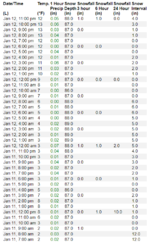
Here's the data for Alta's Collins station. It's located at the bottom of the Collins chair at 9,662 feet, which is near Alta's base.
You can see it snowed 12 inches there by 7am on the 11th, and the data was scrubbed clean to 0.0" at 9am. Then it snowed 6 more inches by 9am on the 12th, at which point the data was scubbed to 0.0" again, and through 11pm tonight they got 4 more inches, so adding that up it's a total of 22 inches in the last day-and-a-half near the base.

1705129468862.png
 
Last edited:

BenedictGomez

Well-known member
Joined
Jan 26, 2011
Messages
12,923
Points
113
Location
Wasatch Back
The last thing to note about this is that it's pretty new & very wonky. You'll notice many data errors, but in general the linear time trend is correct. So just ignore the errors & move on.

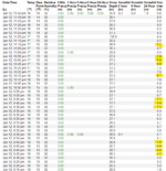
For instance, the below is a weather station at Deer Valley located near the base of Empire Express at 8,300 feet. It was scrubbed at noon today, so we can see 8.6 inches fell in the last 12 hours. But look at all the data points I highlighted in yellow, these are bad reads. Ignore them, and you can see that over time the machine "recovers" and directionally will get it right. I imagine in the coming years more stations will be fitted with this technology & it will probably get better.

1705131378891.png
 
Last edited:

thetrailboss

Moderator
Staff member
Moderator
Joined
Jun 4, 2004
Messages
33,727
Points
113
Location
NEK by Birth
I thought I'd share this as some may find it useful. NWS has a relatively new product at limited stations whereby you can view snowfall as a time series. What this means is you can see exactly how much it really snowed without relying on the ski resort's potentially.... suspect information, or even just delayed info given most ski resorts only update snowfall information once daily, and early in the morning. With this tech you can see how much it snowed at say.... 10pm before you go to bed, and where, and for the areas with multiple functioning weather stations with this tech you can perhaps see how much snow's fallen at the base or mid-mountain or the summit rather than relying on one nebulous figure stated by the resort.

So how does this work? Basically a sensor emits an ultrasonic pulse & then measures the time between sending the signal & receiving the return of the ultrasonic pulse. Various stations have different snow reporting intervals for this, but you just add up the data. The tough part of putting this together was finding the stations which have this new technology, because most dont. For instance, Powder Mountain has 3 weather stations, but only 1 with this ability, but I had to check them all to confirm. When I did locate a functioning station, I'd use latitude & longitude to "find" where they are on the mountain to figure out the actual location.

The below example is an Excel spreadsheet I created for the Wasatch, but if you like this idea of seeing for yourself how much it really snowed, or just dont want to wait for the moutain to report it at 7am, you can create your own spreadsheet for whatever state or region you want by finding the stations at:


1) Click, "Observations"
2) Click, "Surface Observations"
3) Zoom into wherever you wish to find a station. The + symbols on the maps are weather stations.
4) Click, "Historical Observations: 3 Day"

View attachment 60479
Good stuff.
 

BenedictGomez

Well-known member
Joined
Jan 26, 2011
Messages
12,923
Points
113
Location
Wasatch Back
The Northeast ones are mostly at airports and don't help out nor can I find any snow info just percip

Yes, but it's coming is my point. As I mentioned this is pretty new stuff. Why did they choose to roll this out mostly to the west first? No idea. Maybe because there's more snow for testing? Looks like Mount Washington's going to have it soon, while the data fields are all blank for snow, the website was updated to display snowfall over time. Stowe has time-lapsed precipitation, but not snow yet. Give it another year or so and my guess is this will be in many more places. I think it will be an amazing tool for skiers, and I just wanted to point it out as my guess is few know about it.

1705178874997.png
 

thetrailboss

Moderator
Staff member
Moderator
Joined
Jun 4, 2004
Messages
33,727
Points
113
Location
NEK by Birth
Yes, but it's coming is my point. As I mentioned this is pretty new stuff. Why did they choose to roll this out mostly to the west first? No idea. Maybe because there's more snow for testing? Looks like Mount Washington's going to have it soon, while the data fields are all blank for snow, the website was updated to display snowfall over time. Stowe has time-lapsed precipitation, but not snow yet. Give it another year or so and my guess is this will be in many more places. I think it will be an amazing tool for skiers, and I just wanted to point it out as my guess is few know about it.

View attachment 60500
I think that you will be seeing some really impressive totals for Brighton and LCC after tonight. It was dumping up there.
 
Top