powderfreak
New member
- Joined
- Jan 9, 2007
- Messages
- 256
- Points
- 0
On Friday night at the Meatheads party, I was asked about snow and said I
feel confident we *see* white up top by this weekend...now, whether or not
its snow or rime is still up in the air. BUT, all heads should be turned to
the highest elevations come Friday morning. This post is aimed at the
S'bush-Jay corridor in VT.
The idea of an early season nor'easter has been scratched, as the upper
level trough forces a weak surface low too far n/e of us to matter.
However, this large cut-off upper level low will be sitting just to our
north in Quebec...the PSU E-Wall GFS has this at -3 S.D. over southern
Quebec and with heights that low, it will certainly support freezing temps
down to 3K feet. My rule of thumb for snow levels is to forecast it
750-1,000ft below freezing levels, so ~2,000ft with this event in N.VT.
Temperatures: Going off the mass fields of the GFS, the timing is perfect
for early season snow as it swings the H5 trough through/south of our area
Thursday evening with showers continuing into Friday morning. Our summit
level temps plummet to as low as -5C north of 89 and -3C south by early
Friday. I do think the GFS is a little too extreme here and would plan on
modifying that up 1-2C. Critical thicknesses support higher elevation snow
beginning near 12a Fri, dropping to 2K feet briefly near 4-6am, then heading
back towards 4K feet by 10-11am. It is interesting to note, the EURO is
about 12 hours later with this feature and extends the cold through the
weekend. I'll fine tune timing for you boys tomorrow and Thursday.
Precipitation: Here's my concern...we're not going to have any synoptic
precipitation to work with and will have to use meso-scale forcing to get
showers. With this early season cold, Lake Ontario will start producin'.
Cold pool aloft and 40kts at H85 will also initiate showers over the higher
terrain. Mean low level flow is out of the WSW and not north...so this will
not have our usual NW upslope flow. Whenever we see these WSW flows, here's
how it goes down...showers spark off Ontario and track across the 'Dacks,
deposit snow, dry out as they downslope into the CPV, then explode again
over the Green Mtn spine.
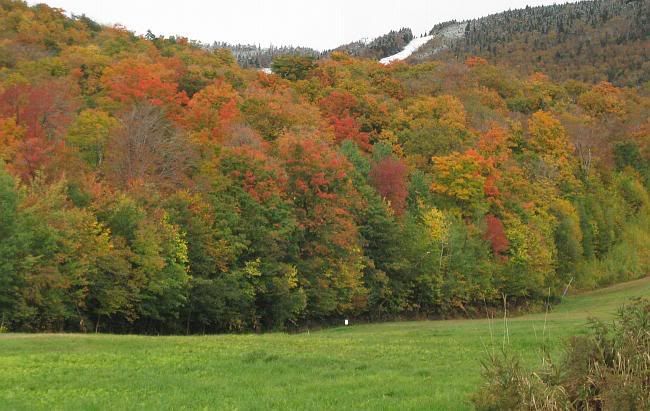
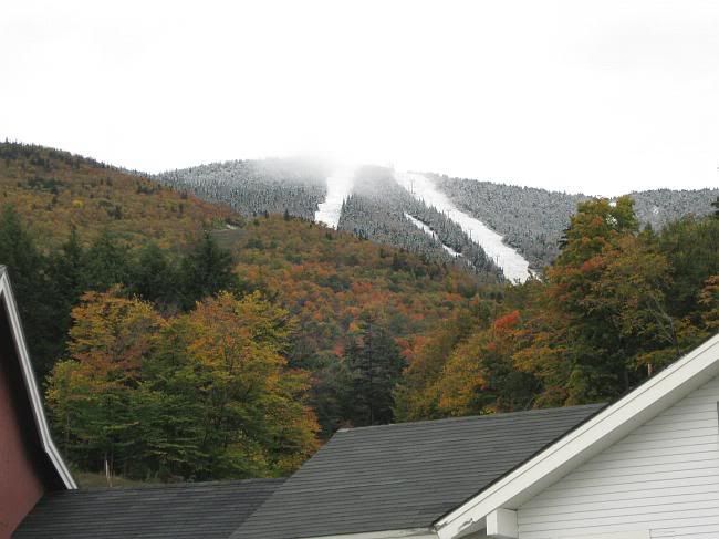
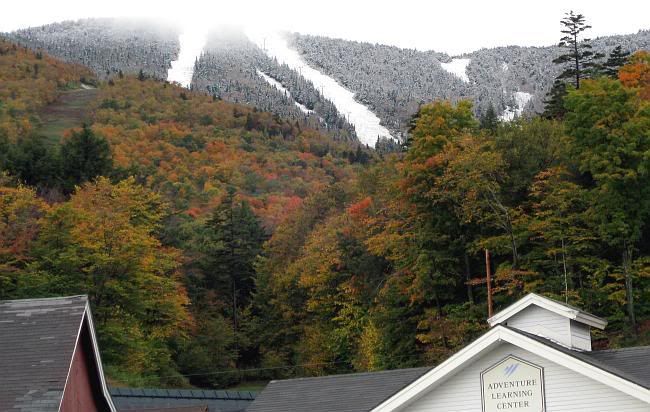
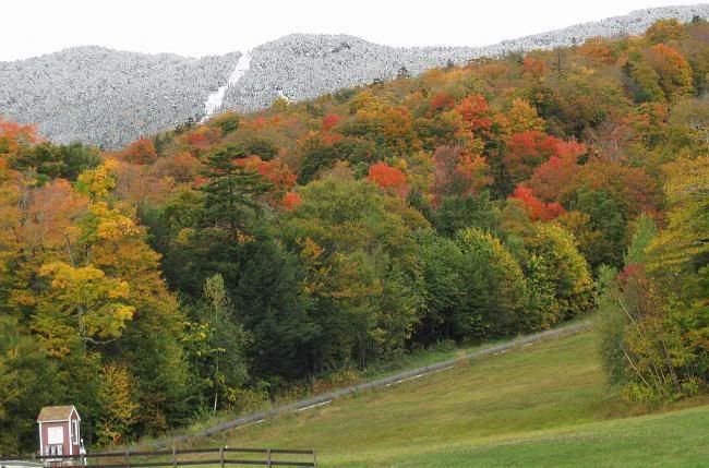
Bottom Line: Rain showers will mix and change to snow showers above 2,500ft
on Thursday night, with a trace to 2" accumulation expected above 3,000ft by
noon Friday especially north of 89. At MRG and Sugarbush, I do think the
summits see flakes though if I was looking for any real accumulation at all
I'd head towards Mansfield/Jay where the cold is a little deeper.
I'll have more concise follow up forecasts as we get closer to the
event...primarily for our Junkboarders. I don't think I'll be heading out
for this *event* but I know some will want to head up. For first tracks
in E.US this season, I'd watch the Adirondacks, there is definitely the
chance for more like 2-4" atop Whiteface's auto road come Friday morning.
First tracks of the season are up for grabs!
-Scott
feel confident we *see* white up top by this weekend...now, whether or not
its snow or rime is still up in the air. BUT, all heads should be turned to
the highest elevations come Friday morning. This post is aimed at the
S'bush-Jay corridor in VT.
The idea of an early season nor'easter has been scratched, as the upper
level trough forces a weak surface low too far n/e of us to matter.
However, this large cut-off upper level low will be sitting just to our
north in Quebec...the PSU E-Wall GFS has this at -3 S.D. over southern
Quebec and with heights that low, it will certainly support freezing temps
down to 3K feet. My rule of thumb for snow levels is to forecast it
750-1,000ft below freezing levels, so ~2,000ft with this event in N.VT.
Temperatures: Going off the mass fields of the GFS, the timing is perfect
for early season snow as it swings the H5 trough through/south of our area
Thursday evening with showers continuing into Friday morning. Our summit
level temps plummet to as low as -5C north of 89 and -3C south by early
Friday. I do think the GFS is a little too extreme here and would plan on
modifying that up 1-2C. Critical thicknesses support higher elevation snow
beginning near 12a Fri, dropping to 2K feet briefly near 4-6am, then heading
back towards 4K feet by 10-11am. It is interesting to note, the EURO is
about 12 hours later with this feature and extends the cold through the
weekend. I'll fine tune timing for you boys tomorrow and Thursday.
Precipitation: Here's my concern...we're not going to have any synoptic
precipitation to work with and will have to use meso-scale forcing to get
showers. With this early season cold, Lake Ontario will start producin'.
Cold pool aloft and 40kts at H85 will also initiate showers over the higher
terrain. Mean low level flow is out of the WSW and not north...so this will
not have our usual NW upslope flow. Whenever we see these WSW flows, here's
how it goes down...showers spark off Ontario and track across the 'Dacks,
deposit snow, dry out as they downslope into the CPV, then explode again
over the Green Mtn spine.
Bottom Line: Rain showers will mix and change to snow showers above 2,500ft
on Thursday night, with a trace to 2" accumulation expected above 3,000ft by
noon Friday especially north of 89. At MRG and Sugarbush, I do think the
summits see flakes though if I was looking for any real accumulation at all
I'd head towards Mansfield/Jay where the cold is a little deeper.
I'll have more concise follow up forecasts as we get closer to the
event...primarily for our Junkboarders. I don't think I'll be heading out
for this *event* but I know some will want to head up. For first tracks
in E.US this season, I'd watch the Adirondacks, there is definitely the
chance for more like 2-4" atop Whiteface's auto road come Friday morning.
First tracks of the season are up for grabs!
-Scott
 I'm hoping to see some pictures of white on Friday!