• Welcome to AlpineZone, the largest online community of skiers and snowboarders in the Northeast!

    You may have to REGISTER before you can post. Registering is FREE, gets rid of the majority of advertisements, and lets you participate in giveaways and other AlpineZone events!

The Jay Cloud

Huck_It_Baby

Active member
Joined
Oct 11, 2010
Messages
1,264
Points
36
Location
Colorado
As for the Tug Hill plateau, I discussed this at length with colleagues at a conference over the summer. Some of my trust worthy colleagues really believe that the hill itself enhances snowfall. I am not yet convinced that the elevation has a significant influence vs just being in the right spot downstream of the lake.

I agree. Hard to believe any elevation change on Tug Hill affects snow fall. It's just position at the end of the lake. It's not even really a hill.
 

yeggous

Active member
Joined
Oct 8, 2012
Messages
2,170
Points
36
Location
Eagle, CO
I think you might be incorrect about some of this but am not sure.

I always understood the ADKs are geologically different from the Greens and Catskills and are from the Grenville Orogeny.

The Greens ARE part of the Appalachian mountains. Greens, Whites, Cats, Chic-Chocs, Blue Ridge...all Appalachians.

I should point out though that I didn't exactly Ace Earth Science in 9th grade.

The Appalachians are sort of a catch-all.

The various orogrenies get a bit complicated in this area because they spatially overlap by are temporarily far apart. The Grenville orogeny was a really long time ago (1 billion years ago) and lifted up a massive mountain range along the whole East Coast. Not much is left of it (though there are a few exposures, most in the Adirondacks), but its sediments can be found all the way in the desert southwest.

The Taconic (500 million years ago) and Acadian (400 million years ago) orogenies are especially confusing because the Taconic supplied the sediments which were later uplifted in the Acadian.

The New England hotspot forming the Whites is much more recent at about 100 million years ago. It get really confusing here because the hotspot tracked from Montreal to the White Mountains and offshore and in so doing passed over the northern Greens.
Portion_of_the_New_England_hotspot.png

I actually have a undergrad degree in meteorology and PhD in geology so I want to make sure I am not putting my foot in my mouth (which I was a bit). It turns out Jay is further west that I thought it was. I always thought of it as part of the Northeast Kingdom. Now to correct myself.... this linked image marks the parts of Vermont that in the White Mountains / New England hotspot. Burke is include, Jay is not. I stand corrected. Mea culpa.
 

dlague

Active member
Joined
Nov 7, 2012
Messages
8,792
Points
36
Location
CS, Colorado
basically warmer moister air gets blown up the back side of Jay Peak and then gets cooled rapidly and condenses! The result is precipitation and during the colder times of the year - result in POW days as it snow like the dickens on the other side!
 

crank

Well-known member
Joined
Mar 3, 2005
Messages
1,426
Points
63
Location
CT
If you approach Jay from the west it is the first mountain you hit after the Adirondacks and Lake Champlain. Nothing but flats and farms for 60 or so miles and there's Jay Peak sticking its, well, peak up into the sky to wring snow from the clouds.
 

from_the_NEK

Active member
Joined
Jun 5, 2006
Messages
4,576
Points
38
Location
Lyndonville, VT
Website
fineartamerica.com
No, Jay is not related to the Green Mountains. It's more accurate to group it with the White Mountains. The mountains of the Eastern Townships, Quebec, Jay and Burke in Vermont, and the White Mountains in New Hampshire and Maine were all created by the New England hotspot.
That is completely false. Jay, Sutton, and Orford are part of the Green Mtn ridge. EDIT: Just read you mea culpa and accept :cool:
 

yeggous

Active member
Joined
Oct 8, 2012
Messages
2,170
Points
36
Location
Eagle, CO
That is completely false. Jay, Sutton, and Orford are part of the Green Mtn ridge. EDIT: Just read you mea culpa and accept :cool:

But Bromont is part of the hotspot trace. You can see it clearly in Google maps.

Owl's Head looks ambiguous without putting boots on the ground. This is what I mean about it gets complicated because the hotspot moved across the northern end of Green Mountains.
 

mbedle

Well-known member
Joined
Jun 24, 2013
Messages
1,769
Points
48
Location
Barto, Pennsylvania
No, Jay is not related to the Green Mountains. It's more accurate to group it with the White Mountains. The mountains of the Eastern Townships, Quebec, Jay and Burke in Vermont, and the White Mountains in New Hampshire and Maine were all created by the New England hotspot.

The Green Mountains are related to the Catskills, Adirondacks, and mountains in the Mid-Atlantic. They are the eroded remains of the Taconic and subsequent Acadian orogenies. That is why the Green Mountains, like the Appalachians, have a "spine" whereas the Whites are isolated mountains.

As for the "Jay Cloud", it is mostly from uplift of cold air advection. There is some seeder-feeder action during storms too.

Ladies and Gentleman, we have a geologist amongst us that knows his stuff. In all seriousness yeggous, as a geologist myself, I didn't know Jay Peak was part of the white mountain range. I just assumed it was part of the green mountain range given its location. Thanks for the info.
 

from_the_NEK

Active member
Joined
Jun 5, 2006
Messages
4,576
Points
38
Location
Lyndonville, VT
Website
fineartamerica.com
If you approach Jay from the west it is the first mountain you hit after the Adirondacks and Lake Champlain. Nothing but flats and farms for 60 or so miles and there's Jay Peak sticking its, well, peak up into the sky to wring snow from the clouds.

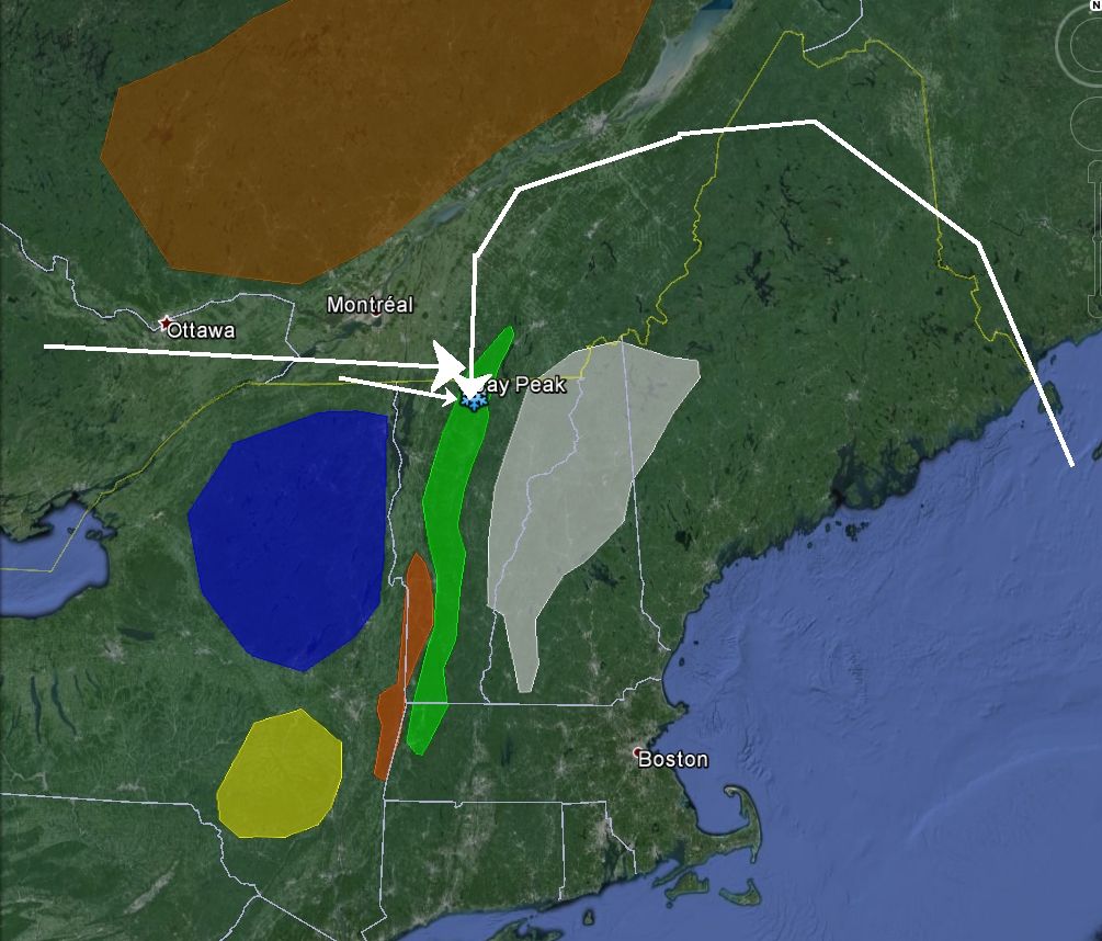
You are mostly correct here. Actually if you go straight West from Jay, you are quite a bit north of the Adirondacks, which can't be said for the Green Mountains farther south. Jay Peak is the first 3000+ foot ridge encountered by any air mass approaching from the West and Northwest. Those air masses get funneled between the Laurentians and the Adirondacks through the St Lawrence Valley and slam into the Jay Peak ridge complex. As stated by others above, the air runs into the mountains and gets forced up and over them which causes orographically enhanced precipitation (aka the “Jay Cloud”).
The wide northern end of Lake Champlain can also add bit of extra moisture to the mix as well.
For Nor-Easter type storms, Jay is one of the few mountains in Vermont that often gets significant snowfall from wrap around moisture. With the counter-clockwise flow around those types of storms, moisture gets thrown up and around the White Mountains. This, with enhancement of strong inflow winds, positions Jay right in a bull’s-eye.

Green = Green Mountain Ridge
White = White Mtns
Brown = Laurentians
Blue = Adirondacks
Yellow = Catskills
Orange = Taconics


yeggous

Active member
Joined
Oct 8, 2012
Messages
2,170
Points
36
Location
Eagle, CO
It's is not... See above

Yeah, I restated. I looked into it further and it looks like Jay, Sutton, and Orford are in the Green.

Bromont and Burke are in the Whites. Owl's Head is ambiguous. For those who know Montreal, Mount Royal is part of the White Mountain range too. Same hotspot trace.

In that area the Greens and Whites get all intermixed and all. Good luck following this thread. :roll:
 

from_the_NEK

Active member
Joined
Jun 5, 2006
Messages
4,576
Points
38
Location
Lyndonville, VT
Website
fineartamerica.com
But Bromont is part of the hotspot trace. You can see it clearly in Google maps.

Owl's Head looks ambiguous without putting boots on the ground. This is what I mean about it gets complicated because the hotspot moved across the northern end of Green Mountains.
Owl's head is definitely, more geologically speaking, a product of the hotspot. However, it is in a position more or less in line with the Green mountain ridge (on the very northern end of it). So it has the benefit of being a part of the larger obstacle in drawing moisture from the clouds. The other plutonic monadnocks (Bromont, Shefford, etc) that sit out in the middle of the St Lawrence Valley all by themselves, don't have that help.
 

JimG.

Moderator
Staff member
Moderator
Joined
Oct 29, 2004
Messages
12,177
Points
113
Location
Hopewell Jct., NY
I truly enjoy throwing out a simple opinion on something I know little about and then gather the info the results from the debate. This one is still short but the info is epic. This is the one thing I truly learned today. Thank you.
 

Mpdsnowman

New member
Joined
Mar 29, 2012
Messages
370
Points
0
Location
Syracuse, NY
Lake Effect Snow

Lol...

Welp growing up and still living here in Syracuse I can certainly speak on that of Lake Effect and my many years at Jay and other places in the area ie Tug Hill etc. have certainly dealt me my fair shares of LE...

Basically its simple..Wind direction, speed, consistency, The lakes position, size and temperature all play apart in this awesome and well played scenario we have in the NE.

Lake Ontario is the usual and most meteorological lake which acts as the catalyst if you will. In regards to Jay peak there is this little lake thats sits just to the right of it. Its not a big body of water...doesn't have to be. But its sooo settled down in that valley that the moisture it produces is plenty enough to be sucked up to produce a lake effect cloud and once it hits smack on the 4k elevation of the top its snow.....Thats why we tend to see that nice coating in the am....

Now a heavy sustained system that we had last week that put some snow on the ground here really cranked up at jay because the preceding bodies of water like champlain and ontario and even little lakes in Canada set it up to really give it something we all got jealous for lol...


Thats my take anyway lol...
 

from_the_NEK

Active member
Joined
Jun 5, 2006
Messages
4,576
Points
38
Location
Lyndonville, VT
Website
fineartamerica.com
Basically its simple..Wind direction, speed, consistency, The lakes position, size and temperature all play apart in this awesome and well played scenario we have in the NE.
Lake Ontario provides very little Lake Effect moisture to Jay. The cold wind would have to be blowing out of the WSW and then the moisture must survive the crossing of the Adirondacks before hitting Jay. That setup does not occur very often enough to have a significant boost in snowfall at Jay. The wide northern end of Lake Champlain and to some extent the wide sections of the St Lawrence River can provide a bit of moisture into cold NW winds that hit Jay and can result in multiple VERY fluffy inches. However, the bigger dumps are reserved for larger systems like Alberta Clippers that already have some moisture in them.
 
Last edited:

dlague

Active member
Joined
Nov 7, 2012
Messages
8,792
Points
36
Location
CS, Colorado
Lake Ontario provides very little Lake Effect moisture to Jay. The cold wind would have to be blowing out of the WSW and then the moisture must survive the crossing of the Adirondacks before hitting Jay. That setup does not occur very often enough to have a significant boost in snowfall at Jay. The wide northern end of Lake Champlain and to some extent the wide sections of the St Lawrence River can provide a bit of moisture into cold NW winds that hit Jay and can result in multiple VERY fluffy inches. However, the bigger dumps are reserved for larger systems like Alberta Clippers that already have some moisture in them.

Orographic lift occurs when an air mass is forced from a low elevation to a higher elevation as it moves over rising terrain. As the air mass gains altitude it quickly cools down adiabatically, which can raise the relative humidity to 100% and create clouds and, under the right conditions, precipitation. In Jay Peaks case - SNOW!
 

WWF-VT

Well-known member
Joined
Sep 23, 2005
Messages
2,598
Points
48
Location
MA & Fayston, VT
From a VT meteorologist:

Of course, much of this was opinion and conjecture, and what I needed was science-based fact. So I called Andy Nash, a meteorologist with the National Weather Service in Burlington. “I haven’t heard it referred to as the Jay Cloud, but from our perspective, it’s a well-known fact,” he says. “It’s cloudier and they get more snow in the Jay Peak area, and when we do our forecasts, we take that into account.” It all, he says, comes down to topography.

“The way the mountain is oriented along a northeast-southwest line places it perfectly perpendicular to the northwest winds that we get a lot in winter,” he explains. Those winds hit the mountain, rise, clouds form, “and in winter, you get snow to fall, and the snowfall adds up pretty quickly.”

It’s the orthographic uplift Butson was talking about, but according to Nash, Jay is optimized in both its orientation and its location. “As you go farther down the Green Mountains into southern Vermont, the mountain orientation isn’t as perpendicular to the northwest winds,” he explains. “Also, in the southern parts of the state, the winds go over the Adirondacks first, where they drop some of their moisture before reaching Vermont. But upstream of Jay, there are no mountains to steal moisture.”

That source of moisture that feeds the Jay Cloud isn’t, as you might expect, the Great Lakes, or Lake Champlain, or the St. Lawrence. Rather, and surprisingly, it’s the Atlantic. When a low pressure system sits just to the east of Vermont, the winds spin counterclockwise around that low, pulling in moisture from the Atlantic, wrapping around to the north, and then smacking into Jay from the northwest. “That’s when Jay gets the winds and the snow,” Nash says.
 

Huck_It_Baby

Active member
Joined
Oct 11, 2010
Messages
1,264
Points
36
Location
Colorado
I truly enjoy throwing out a simple opinion on something I know little about and then gather the info the results from the debate. This one is still short but the info is epic. This is the one thing I truly learned today. Thank you.

Yes this thread is great!
 
Top