• Welcome to AlpineZone, the largest online community of skiers and snowboarders in the Northeast!

    You may have to REGISTER before you can post. Registering is FREE, gets rid of the majority of advertisements, and lets you participate in giveaways and other AlpineZone events!

2/7-2/9

4aprice

Well-known member
Joined
Mar 14, 2008
Messages
3,991
Points
63
Location
Lake Hopatcong, NJ and Granby Co
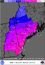
No matter what we are still going to get 3-6 inches of snow at the minumum. Even if the storm goes out to sea on Friday night, the strong clipper moving through on Friday will deliver snow.

View attachment 7581

Wow, this would be one helluva storm if this pans out.

That Euro is a dream (or nightmare if you lived through 78 for Boston.) Should be saved just to show what these models can dream up. Think we're due for a good hit but not sure this is it.


Alex


Lake Hopatcong, NJ
 

Euler

Active member
Joined
Jan 28, 2007
Messages
1,063
Points
36
Location
Southern Vermont
I need to ski my new Skilogiks in powder yet.
You just may get to do that on Saturday!

Things stayed good overnight and NOAA out of Albany has come out with a Winter Storm Watch. I might just get my chance to get to Magic this Sat!:grin:
 

MattMc

New member
Joined
Jan 17, 2013
Messages
12
Points
0
No matter what we are still going to get 3-6 inches of snow at the minumum. Even if the storm goes out to sea on Friday night, the strong clipper moving through on Friday will deliver snow.

View attachment 7581

Wow, this would be one helluva storm if this pans out.

Now this is looking promising for this w/e!
 

WinnChill

New member
Joined
Nov 13, 2009
Messages
921
Points
0
and (drumroll please) Vermont?

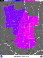
I'm a drummer too, so bddddddddddd...CRASH....Vermont State Summary Page. Upslope may not be as strong for them as they benefit mostly from the Midwest portion of this system and then maybe backedge effects from the coastal low--sort of in between but still good potential for accumulation.
 

BenedictGomez

Well-known member
Joined
Jan 26, 2011
Messages
12,552
Points
113
Location
Wasatch Back
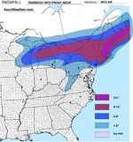
enjoy the graphic...its from inaccuweather for whatever that's worth.

View attachment 7584

The amazing thing to me is that if you look at the "bigs" like Accuweather, etc... they're really downplaying this compared to the Euro model runs. I dont know if it's because they're going with the GFS (which was initially WRONG about this storm keep in mind) or if they're just being conservative, but there are Euro runs now showing around 10" in NJ where the above 1" to 3" is, and 16" to 20" in CT where their 6" to 12" range is. In other words, just going off the Euro, which has been most correct so far, the news outlets are running the risk of way underdoing this. Fingers crossed.
 

billski

Active member
Joined
Feb 22, 2005
Messages
16,207
Points
38
Location
North Reading, Mass.
Website
ski.iabsi.com
Note to self: little work getting done today.
Note to all: probability of crankiness have decreased to 0 to 10% except in areas of poor driving causing significant delays, where the factor could be as high as 90%.

As the NHC likes to say: "[You are] urged for preparations to protect life and property to be rushed to completion." And don't forget your boots.
 

BenedictGomez

Well-known member
Joined
Jan 26, 2011
Messages
12,552
Points
113
Location
Wasatch Back
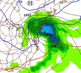
Not a forecast like the above pics, but if you just want a glimpse of what the Euro is depicting....

bcbn2vecyaauhvjpglarge.jpg
 

Abubob

Well-known member
Joined
Apr 9, 2010
Messages
3,589
Points
63
Location
Alexandria, NH
Website
tee.pub
After light snow all day Friday this would be 8 PM Friday night. Now the heaviest snow we've ever seen but the best this winter has offered.

Screen shot 2013-02-06 at 9.11.48 AM.jpg
 
Top