• Welcome to AlpineZone, the largest online community of skiers and snowboarders in the Northeast!

    You may have to REGISTER before you can post. Registering is FREE, gets rid of the majority of advertisements, and lets you participate in giveaways and other AlpineZone events!

2/7-2/9

billski

Active member
Joined
Feb 22, 2005
Messages
16,207
Points
38
Location
North Reading, Mass.
Website
ski.iabsi.com
There is clearly some variability in these forecasts. There is a very balanced narrative on
http://www.boston.com/news/weather/weather_wisdom/2013/02/blizzard_watch_coastal_flood_w.html

"
...
There is still conflicting information on the exact track of the storm. A wobble closer or further to the coast would ultimately change accumulations by big numbers, but it's still going to be a big storm.
...

he reason the estimated accumulations have such a large range,are that in these very intense storms thundersnow or banding can rapidly add 8-12 inches of snow to an area in just a few hours. Today, some of the computer models will start to indicate if the storm will produce thundersnow or heavy banding (which has extreme snowfall rates) and that will allow me to be even more specific with the final amounts.
...
For the storm Friday night to become historic a lot has to happen. Every key ingredient in the atmosphere must come together in just the right way. Snowfall rates will need to approach 3 inches per hour at least for a few hours. If, for example, it snows at 1 inch per hour from midnight until 5 AM that is going to give us 5 inches of snow, but imagine getting 3 inches per hour during that time, now you just added 15 inches to your total. For Boston and other towns to see final amounts over 18 inches we need to have some incredibly intense snowfall rates for at least part of the storm
...
This is the hard part of forecasting and conveying what the storm will be like before it occurs. Everyone has a different opinion on what makes a bad storm"

This won't stop me from being obsessively optimistic. :)
 

Puck it

Well-known member
Joined
Oct 26, 2006
Messages
9,700
Points
48
Location
Franconia, NH
Love seeing these accumulation projections!!! But let's talk wind for a sec. That could be the dream killer for a lot of us who are pre-positioning for Sat. Whose going to be on hold? Where are the safe spots? I am definitely worried about holds at Cannon. Even if lower mtn lifts stay open with summits closed that is going to pack a LOT of hungry people into a small area. Wildcat is likely to shut down the summit which is a horribly frustrating situation I've experienced way too many times. Loon? Am I actually considering Loon over Cannon on a pow day? A lot more lift options with less wind exposure. Bretton Woods is usually wind immune. But less snow further north and BW doesn't have enough pitch to make a decent pow day worthwhile. Gah!


Loon! Loon! You can not be serious! Winn's site says out of the N NW at Cannon. That direction should be ok for HSQ and summit.
 

Nick

Administrator
Staff member
Administrator
Joined
Nov 12, 2010
Messages
13,178
Points
48
Location
Bradenton, FL
Website
www.alpinezone.com
The Euro actually went even further west and dramatically increased its' snow total for NJ and NYC, but it also depicts less snow for all of ski country now. As much as I love snow, I'd gladly sacrifice it to the mountains.

53150751128356224856838.png

Damn, my in-laws house is literally right in the center of that 30" dot
 

hammer

Active member
Joined
Apr 28, 2004
Messages
5,493
Points
38
Location
flatlands of Mass.
There is clearly some variability in these forecasts. There is a very balanced narrative on
http://www.boston.com/news/weather/weather_wisdom/2013/02/blizzard_watch_coastal_flood_w.html

"
...
There is still conflicting information on the exact track of the storm. A wobble closer or further to the coast would ultimately change accumulations by big numbers, but it's still going to be a big storm.
...

he reason the estimated accumulations have such a large range,are that in these very intense storms thundersnow or banding can rapidly add 8-12 inches of snow to an area in just a few hours. Today, some of the computer models will start to indicate if the storm will produce thundersnow or heavy banding (which has extreme snowfall rates) and that will allow me to be even more specific with the final amounts.
...
For the storm Friday night to become historic a lot has to happen. Every key ingredient in the atmosphere must come together in just the right way. Snowfall rates will need to approach 3 inches per hour at least for a few hours. If, for example, it snows at 1 inch per hour from midnight until 5 AM that is going to give us 5 inches of snow, but imagine getting 3 inches per hour during that time, now you just added 15 inches to your total. For Boston and other towns to see final amounts over 18 inches we need to have some incredibly intense snowfall rates for at least part of the storm
...
This is the hard part of forecasting and conveying what the storm will be like before it occurs. Everyone has a different opinion on what makes a bad storm"

This won't stop me from being obsessively optimistic. :)
David Epstein's blogs have been my go-to for weather info for a while...don't see as much hype.
 

Puck it

Well-known member
Joined
Oct 26, 2006
Messages
9,700
Points
48
Location
Franconia, NH
Yeah NNW...at 50-55MPH!!! Direction counts for a lot but at those speeds all bets are off.


I hear you but I have been there with gusts like that and out of the north and all lifts were running. I saw a woman get blown across uppter tram deck a couple of years ago. I will be watching updates as I drive Sat. Morning for holds.
 

BenedictGomez

Well-known member
Joined
Jan 26, 2011
Messages
12,548
Points
113
Location
Wasatch Back
The thing with this storm, is that it's going to be near impossible for any model to be right.

LOOK at how sharp these snow cutoffs are!

You can go from 12" to 4" in a short drives time. You can go from 30" to 18" in a short drives time, or 6" to NOTHING. I've arrived at the position that we just have to wait and see.

This storm is GOOD for ALL of ski country (Poconos, Cats, DAX, Green, White, ME), whether the mountains get 7" or 17" is my position. Everyone joins this party. How often can we ever say that! Dont worry, be happy.
 

j law

New member
Joined
Jan 19, 2011
Messages
103
Points
0
Location
NYC
Hmmm... Southern VT looks the best from this latest map.
 

dmw

New member
Joined
Feb 29, 2012
Messages
305
Points
0
David Epstein's blogs have been my go-to for weather info for a while...don't see as much hype.

He blogged last weekend that any major snow for the Boston area was increasingly unlikely... Glad he was wrong though!
 

BenedictGomez

Well-known member
Joined
Jan 26, 2011
Messages
12,548
Points
113
Location
Wasatch Back
Here's the 12z GFS that came out a little bit ago. It has lower snow totals for most everyone, because it's predicting the storm moves a bit east.

Whatever, I'm still going with the Euro since its had this storm for days now.

81925248435219827871065.png
 

ScottySkis

Well-known member
Joined
Jan 16, 2011
Messages
12,294
Points
48
Location
Middletown NY
My bus to NYc might be cancelled because of snow. I be on the train tomorrow. I love to ski a powder day at Elk on Saturday and go to Platty on Sunday, or should I go to Gore I dont know.
 

billski

Active member
Joined
Feb 22, 2005
Messages
16,207
Points
38
Location
North Reading, Mass.
Website
ski.iabsi.com
My bus to NYc might be cancelled because of snow. I be on the train tomorrow. I love to ski a powder day at Elk on Saturday and go to Platty on Sunday, or should I go to Gore I dont know.

I understand that Kmart has a bus that picks people up at a nearby (25 miles?) amtrak station. In today's paper, Okemo is planning to do something similar. Not that we have many storms of this magnitude.
 

Smellytele

Well-known member
Joined
Jan 30, 2006
Messages
10,225
Points
113
Location
Right where I want to be
Here's the 12z GFS that came out a little bit ago. It has lower snow totals for most everyone, because it's predicting the storm moves a bit east.

Whatever, I'm still going with the Euro since its had this storm for days now.

Shows VT for the most part only getting 3-6 not that epic as we have been treating it as the snowmagaddon. I also hope for the Euro
 

Glenn

Active member
Joined
Oct 1, 2008
Messages
7,691
Points
38
Location
CT & VT
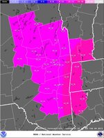
NWS Albany Office still has it looking good for SoVT....14-18"

StormTotalSnowWebFcst.jpg
 
Top