• Welcome to AlpineZone, the largest online community of skiers and snowboarders in the Northeast!

    You may have to REGISTER before you can post. Registering is FREE, gets rid of the majority of advertisements, and lets you participate in giveaways and other AlpineZone events!

First Snowfalls, Upcoming weather and Storms of winter 2022-2023. Storm snow totals, Observations and Predictions?

urungus

Well-known member
Joined
Dec 1, 2016
Messages
2,069
Points
113
Location
Western Mass
11:00am Saturday 2/18/23 Trail offerings for Presidents day weekend

Mount Snow --------- 45/86
Okemo --------------- 98/126
Stratton --------------- 71/99
Killington -------------109/155 (1" last 24hrs)
Sugarbush ------------ 80/111 (snow dusting) trail counts going down as I type :(
Stowe ----------------- 78/128 (1" last 24hrs)
Smugglers Notch -----38/78 (2" last 24hrs)
Jay Peak -------------- 81/81 (4" last 48hrs)

Best snow hunting to all
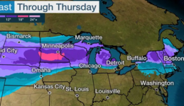
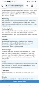
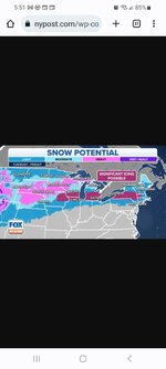
Increasing odds of a good hit from next weeks incoming snow storm with regular snow refreshing on mountains next Wed-Friday and right through next weekend. Great night and some daytime snowmaking weather too in the long range forecasts if the mountains choose to use it,
Jay 100% open !!
 

MidnightJester

Active member
Joined
Oct 7, 2011
Messages
964
Points
43
Jay 100% open !!
That came and went that fast. Jay peak now at 65/81 that 4" didn't last long lol. They will for sure be rocking fully open next Thursday or Friday if the foot plus comes in.
 
Last edited:

MidnightJester

Active member
Joined
Oct 7, 2011
Messages
964
Points
43
Must be a new thing..100% open after a rain flash freeze...
they claimed 4" overnight after the slush. I doubt they were truly open or were just waiting for ropes to be put up. How often does ski patrol check a trail or run? Seems there is usually a 11am(ish) update from mountains on trail counts. Seems that patrol might do a second 10am run to check suspect trails or do all trails get a patrol run regularly?
 

Kingslug20

Well-known member
Joined
Oct 14, 2021
Messages
2,506
Points
113
Feel sorry for them when they have to venture into something like a frozen paradise..
 

urungus

Well-known member
Joined
Dec 1, 2016
Messages
2,069
Points
113
Location
Western Mass
they claimed 4" overnight after the slush. I doubt they were truly open or were just waiting for ropes to be put up. How often does ski patrol check a trail or run? Seems there is usually a 11am(ish) update from mountains on trail counts. Seems that patrol might do a second 10am run to check suspect trails or do all trails get a patrol run regularly?

So both Sugarbush and Jay Peak were listed as 100% open at the start of the day, then lost dozens of trails in the first couple hours. The impression that gives is that they aren’t bothering to check the safety of every trail before opening for the day, which is unsettling.
 

cdskier

Well-known member
Joined
Mar 26, 2015
Messages
6,704
Points
113
Location
NJ
So both Sugarbush and Jay Peak were listed as 100% open at the start of the day, then lost dozens of trails in the first couple hours. The impression that gives is that they aren’t bothering to check the safety of every trail before opening for the day, which is unsettling.
Just because the trail was listed as open on the report doesn't mean it was actually open on the mountain. Sugarbush did not start with all trails open this morning. At Mount Ellen none of the natural trails were opened until patrol checked them at the start of the day. And most remained closed due to patrol's decisions. I'd suspect LP was very similar. So they didn't "lose dozens of trails in the first couple of hours". They were never open at all in most cases. Overly optimistic reporting/expectations from mountain ops perhaps and a bit slow to update the website to reflect the reality on the mountain. But from a safety perspective nothing at all unsettling as patrol made the proper calls before people started skiing any trails. I was at ME at 8am...and I even laughed when I looked at my phone at 9am and saw the report still showing "100%" open.

I can't speak for Jay though...
 
Last edited:

MidnightJester

Active member
Joined
Oct 7, 2011
Messages
964
Points
43
Feel sorry for them when they have to venture into something like a frozen paradise..
Bad glazed and frozen over "black" anything is a frightening experience. Forget about doing a few "double blacks" and then giving a report on how many times it was zero fun and barely safe but you can make it down "ugggg" trails open.
 

Kingslug20

Well-known member
Joined
Oct 14, 2021
Messages
2,506
Points
113
Wonder what would happen if they ordered someone to check the trail out...and they say..no...way...
 

MidnightJester

Active member
Joined
Oct 7, 2011
Messages
964
Points
43
So snow is on the way. Here's to hoping is stalls on top of the Northeast with some back end powder.
1676910240904.png
forecast-snowfall-early-call-1676904637.png
 
Last edited:

Scottyskis2

Active member
Joined
Dec 17, 2022
Messages
433
Points
28
From reliable weather forecast er
Rebecca:
"""The surface chart, shows weak low pressure with a cold front approaching, with another right behind it. Both of these will be moving through over the next couple of days, keeping things unsettled. Tomorrow into early Wednesday, we will have the 2nd system move through, this will bring rain and snow showers to the region. There could be 1-3 inches of snow for the Catskills, Berkshires, Greens, whites, into Maine. The Adirondacks will likely see a general 1-3 with the high peak area having a chance for 3-6 inches of snow. For the rest of New York State and Central New England a dusting to an inch is possible.

Then we get into a complex setup for later Wednesday through Friday. We will have a couple of areas of low-pressure approach. We will have a cold high up in Canada, allowing for some cold air to drain into the region. We will also have a warm front that will be advancing northward. The cold air dropping south won’t be super cold but it will be cold enough for snow over the northern part of the region. How far the warm front makes it will determine where the best chance for all or mostly all snow will fall.

Wednesday into Thursday we will have low pressure moving over New York State and across New England. Then for Thursday night into Friday another area of low pressure will move through, this on just a little farther north. Right now, those north of I-90, Vermont, New Hampshire and Maine, will have to best chance of seeing mostly or all snow, especially in the higher elevations. These areas look to see several inches of snow. We will have that warm front advancing northward. For later Wednesday into Thursday, the warm air will be overrunning that blanket of cold air out of Canada. So, for the northern tier of Pennsylvania and areas along and south of I-90 (especially the Pocono and Catskill Mountains), Northwest New Jersey, Connecticut, Massachusetts, and Rhode Island, will likely start out as a mix of sleet and freezing rain before changing over to rain. But these areas will likely see a dusting to 4 inches of snow on the front side of the storm. How much Ice will depend on where the warm frontal boundary sets up and elevation. For those areas south like the I-95, this looks to be primarily a rain event.

The cold air will make more inroads into the region on Friday into the Weekend. As the storm moves away, we will see some lake effect snow for Friday that could last into the afternoon. Right now lake effect looks to be limited. Friday will also see very gusty winds.
Saturday will see another weak area of low pressure to our south. This will bring a chance for rain/snow showers. But any snowfall accumulation will be light and confined to the higher elevations."
😀
Sunday, I posted on the long range. In it I said the North Atlantic Oscillation (NAO) is going negative. Many know that a negative NAO is sign for cold air in the east CONUS. In the post I talked on how East Based NAO and a West Based NAO are important as to where the cold air and storm track will set up. I want to add some clarity to what I said. This is about as plain speak as I can make it.

The position where the high pressure associated with the NAO sets up, is vital in how cold the Northeast and northern Middle Atlantic get

Eastern Based…

Allows for a high-pressure ridge build into eastern Greenland which allows for below normal heights over the Atlantic and Iceland, it also favors below average heights over the Midwest and Plains.

Western Based…

Has the high-pressure ridge build through Greenland into Northeast Canada. This allows for an upper-level low (50/50 low) over the Canadian Maritimes. We also have the colder air move into the Eastern CONUS. The western NAO forces the storm track south. Where the storms can come out of the south and move up the Eastern Seaboard.

Here are a couple of images I found on the Web. The differences may not look to be a big deal. But trust me it is. This winter has been a battle between the Western Teleconnections and the Eastern Teleconnections. So far for most of this winter the Western Teleconnections have been in the driver’s seat; as a result, the Southeast Ridge has destroyed our winter cold and storm chances.

Here is a look at the NAO index forecast and the PNA index forecast. When the NAO is negative cold air is more likely in the northern tier of the CONUS. When the PNA is negative we see the Southeast Ridge become strong. This winter had the NAO mainly positive during January and the first half of February. While the PNA had more in the way of variation, but it was on average more positive than negative. So, the Southeast Ridge has been a bigger player than it was forecast to be. As a result, we had a lot of warmth here in the Northeast and Middle Atlantic.

Looking back at the NAO and PNA diagrams. We can see the NAO is going negative. But the PNA is also going negative. So, while the pattern has changed. The result of both negative. Is that the Southeast Ridge won’t be as suppressed as much as it would have been, if the negative NAO had been truly West Based. We can see this in the 500mb anomalies charts from Tropical Tidbits. Currently we have lower heights over Eastern Canada and Greenland; the Southeast Ridge is very prominent, and there is no 50/50 low in place. As we look at the other images, we can see that the high pressure sets up mainly east of Greenland, so the lower heights are heading for Europe. Then slowly the high pressure ridging retrogrades back toward Greenland, So by the end image we have part of the ridge over Eastern Canada and a weak 50/50 low trying to form. But if we look at the West Based NAO image, we can see the NAO setup is not a true West Based and isn’t ideal for long lasting cold and a more favorable storm track of the Northeast. That Southeast Ridge is still putting a lot of influence on the pattern.

I’ve been talking about the Stratospheric Warming Event and the Polar Vortex quite a bit over the last few weeks. I had a question about the PV and how it would influence our end of winter and first part of Spring. My answer was “The PV is breaking down about a month earlier than it does typically. So the PV is heading into its typical spring time setup, that's another step in the wrong direction for a big recovery to a big winter like pattern. So, while there is a chance for things to change, time is running down, I'm not saying there isn't a chance for a turnaround, I'm just saying the odds are long and getting longer everyday”

But this is why I posted what I did on Sunday, and why my Spring Outlook reads like it does.

I hope this clears things up at least a little.
 

Kingslug20

Well-known member
Joined
Oct 14, 2021
Messages
2,506
Points
113
At this point the morning report from Stowe and SB is all that matters. Forecasting this winter is impossible..
 

ThatGuy

Well-known member
Joined
Feb 10, 2021
Messages
1,675
Points
113
Location
Park City
I put my nose out the door and see whats on the ground. Thats as accurate at it gets…
This year you don’t know what you’re in for until the morning of.
Thursday-Friday looking great so far though…
 

cdskier

Well-known member
Joined
Mar 26, 2015
Messages
6,704
Points
113
Location
NJ
Of course it is going to finally snow...I'm going back to NJ Friday for a funeral...
 
Top