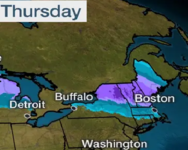
-
Welcome to AlpineZone, the largest online community of skiers and snowboarders in the Northeast!
You may have to REGISTER before you can post. Registering is FREE, gets rid of the majority of advertisements, and lets you participate in giveaways and other AlpineZone events!
You are using an out of date browser. It may not display this or other websites correctly.
You should upgrade or use an alternative browser.
You should upgrade or use an alternative browser.
First Snowfalls, Upcoming weather and Storms of winter 2022-2023. Storm snow totals, Observations and Predictions?
- Thread starter MidnightJester
- Start date
Kingslug20
Well-known member
- Joined
- Oct 14, 2021
- Messages
- 2,506
- Points
- 113
Gotta decide if ill be epic..or ikonik..
MidnightJester
Well-known member
- Joined
- Oct 7, 2011
- Messages
- 1,075
- Points
- 83
Freezing sleet came in Monday night and seems Stowe is reporting Cross country trails closed due to icing over and any ungroomed steeper terrain are also frozen over and closed. Figuring many of Vermont mountains came out the same. Here's to winter storm Olive's arrival and the snow show we are hoping it produces.
Jay Peak is reporting it pulled 3" out of Monday nights weather. still 65/81 trails.
"Ullr Ullr Ullr"
Jay Peak is reporting it pulled 3" out of Monday nights weather. still 65/81 trails.
"Ullr Ullr Ullr"
Last edited:
Scottyskis2
Active member
- Joined
- Dec 17, 2022
- Messages
- 433
- Points
- 28
The surface chart shows one area of low pressure exiting the northern Middle Atlantic Coast, with two other areas of low pressure and the trough approaching from the West.Sunday, I posted on the long range. In it I said the North Atlantic Oscillation (NAO) is going negative. Many know that a negative NAO is sign for cold air in the east CONUS. In the post I talked on how East Based NAO and a West Based NAO are important as to where the cold air and storm track will set up. I want to add some clarity to what I said. This is about as plain speak as I can make it.
The position where the high pressure associated with the NAO sets up, is vital in how cold the Northeast and northern Middle Atlantic get
Eastern Based…
Allows for a high-pressure ridge build into eastern Greenland which allows for below normal heights over the Atlantic and Iceland, it also favors below average heights over the Midwest and Plains.
Western Based…
Has the high-pressure ridge build through Greenland into Northeast Canada. This allows for an upper-level low (50/50 low) over the Canadian Maritimes. We also have the colder air move into the Eastern CONUS. The western NAO forces the storm track south. Where the storms can come out of the south and move up the Eastern Seaboard.
Here are a couple of images I found on the Web. The differences may not look to be a big deal. But trust me it is. This winter has been a battle between the Western Teleconnections and the Eastern Teleconnections. So far for most of this winter the Western Teleconnections have been in the driver’s seat; as a result, the Southeast Ridge has destroyed our winter cold and storm chances.
Here is a look at the NAO index forecast and the PNA index forecast. When the NAO is negative cold air is more likely in the northern tier of the CONUS. When the PNA is negative we see the Southeast Ridge become strong. This winter had the NAO mainly positive during January and the first half of February. While the PNA had more in the way of variation, but it was on average more positive than negative. So, the Southeast Ridge has been a bigger player than it was forecast to be. As a result, we had a lot of warmth here in the Northeast and Middle Atlantic.
Looking back at the NAO and PNA diagrams. We can see the NAO is going negative. But the PNA is also going negative. So, while the pattern has changed. The result of both negative. Is that the Southeast Ridge won’t be as suppressed as much as it would have been, if the negative NAO had been truly West Based. We can see this in the 500mb anomalies charts from Tropical Tidbits. Currently we have lower heights over Eastern Canada and Greenland; the Southeast Ridge is very prominent, and there is no 50/50 low in place. As we look at the other images, we can see that the high pressure sets up mainly east of Greenland, so the lower heights are heading for Europe. Then slowly the high pressure ridging retrogrades back toward Greenland, So by the end image we have part of the ridge over Eastern Canada and a weak 50/50 low trying to form. But if we look at the West Based NAO image, we can see the NAO setup is not a true West Based and isn’t ideal for long lasting cold and a more favorable storm track of the Northeast. That Southeast Ridge is still putting a lot of influence on the pattern.
I’ve been talking about the Stratospheric Warming Event and the Polar Vortex quite a bit over the last few weeks. I had a question about the PV and how it would influence our end of winter and first part of Spring. My answer was “The PV is breaking down about a month earlier than it does typically. So the PV is heading into its typical spring time setup, that's another step in the wrong direction for a big recovery to a big winter like pattern. So, while there is a chance for things to change, time is running down, I'm not saying there isn't a chance for a turnaround, I'm just saying the odds are long and getting longer everyday”
But this is why I posted what I did on Sunday, and why my Spring Outlook reads like it does.
I hope this clears things up at least a little.
I saw a question on one of the posts yesterday, “How did we go from the … this is best set up in several years for the I 95, region for snow and cold …. To the top 3 warmest winters winter ever / and no snow” ? The answer, On the IR satellite we can see both the subpolar Jet and the polar jet are both very active, but they aren’t phasing. This has been the case for this entire winter, an active weather pattern with no interaction between the two jet streams.
The two clippers, will keep things unsettled today thru tomorrow, with rain showers and snow showers. Snow accumulation will be reserved for the higher elevations. The Pocono’s and Catskills could see 1-2 inches, while the Adirondacks, Berkshires, Greens and Whites pick up a general 1-3 inches with locally higher amounts possible, especially in the Adirondacks.
Then we will watch a storm approach, currently over the Rockies. This one will be moving through the Midwest and Ohio Valley on Wednesday. As the storm approaches a warm front will be lifting northward. And cold air will be falling out of Canada; this will set the stage for a snow storm over northern New York State and northern into Central New England, With a mix and rain south of there. There is some concern for Ice across the New York State Southern Tier, southern Massachusetts and the rest of Southern New England into Eastern Pennsylvania.
Northern New York State north of the I-90, far northern Massachusetts, Vermont, New Hampshire and Maine, look to see a general 6-12 inches of wet snow, with localized higher amounts possible. The farther south you are in this area the greater your chance of seeing a bit of a mix. For western central into the mid-Hudson Valley of New York State, across the rest of Massachusetts. Things will start out as snow then as warmer air moves in aloft there will be a transition to sleet and freezing rain. Depending on how much sleet falls, will determine how much snow. But a general 1-4 inches of snow is looking likely with locally higher amounts possible. For Connecticut, Rhode Island, the Twin Tiers of New York State and Pennsylvania depending on how much sleet and ice falls, there could be a dusting to and inch or so of snow. For areas south of there it is looking like a quick mix at the start then plain rain.
Winds will be gusty Wednesday night into Friday.
For the New York State Southern Tier, southern Massachusetts and the rest of Southern New England into Northeastern Pennsylvania, heavy freezing rain is a danger, amounts of over a ¼ of an inch will be possible.
Friday we will see a second area of low-pressure track to our north. This could lead to some lake effect, but accumulations look to be limited to 1-6 inches of snow for those downwind of the Lakes.
Kingslug20
Well-known member
- Joined
- Oct 14, 2021
- Messages
- 2,506
- Points
- 113
Me too..follow the slime trailI’ll be in line for the FourRunner by 730 Thursday…finally a good storm
MidnightJester
Well-known member
- Joined
- Oct 7, 2011
- Messages
- 1,075
- Points
- 83
Kingslug20
Well-known member
- Joined
- Oct 14, 2021
- Messages
- 2,506
- Points
- 113
Scottyskis2
Active member
- Joined
- Dec 17, 2022
- Messages
- 433
- Points
- 28
From Rebecca Facebook page
Yes it here winter for little while
"""
For the weekend, we have a few weak systems moving through, one will bring a bit of snow to New York State and northern and central New England, snow amounts will be a dusting to perhaps three inches. The southern storm will bring a wintery mix to southeast Pennsylvania, part of southern New Jersey, Maryland and Delaware. There is a chance for a little accumulation in spots, especially higher elevations.
Tomorrow high pressure will build in allowing for clearing skies and temperatures will warm.
Then for Monday afternoon and thru Tuesday we will see another stronger system impact the region. This will be similar to the Wednesday event, but it will also have a coastal component. We will have a primary that will move into the Great Lakes. Bringing some snow to twin tiers of NYS and PA, along with the rest of New York State and New England. We will see a secondary coastal low develop, this will track south of New England and head into the Gulf of Maine. This will briefly lock in some colder air over Northern New York State back into Eastern New York State and New England. Significant snow is possible for some where in this area. Even Southern Massachusetts (including Boston) and Connecticut, could see several inches of accumulation. This is also going to be an overrunning event with warm air nosing northward into the region. I am a bit concerned for more in the way of a prolonged icing event for Southern New York State into Southern New England. rain event for Pittsburgh and the rest of southern Pennsylvania, Maryland Delaware and Southern and Central New Jersey, including Washington, D.C., Baltimore and Philadelphia this looks to be mainly a rain event. New York City and Long Island could end up with a wintery mix. The actual track will determine who sees what.
Wednesday we will see an area of high-pressure build allowing for clearing, then we will see another system come in for Thursday into Friday. I will post more on the Monday/Tuesday event tomorrow.
Looking at the long range.
Right now, everything I said in my Spring Outlook looks to be on track.
The Sudden Stratospheric Warming (SSW) event did indeed fracture the Polar Vortex (PV). As I explained in the last long-range post, The largest piece of the PV is over Asia, while a smaller piece is sitting over Northern North America. So, while the majority of the cold is in Asia, we do have some cold extending into the northern CONUS.
La Nina is still weakening. But it is still exerting influence on the entire pattern. As a result, the Southeast ridge is still pronounced. With the Subtropical Jet, forced to go above it, as it sends waves of energy toward the Middle Atlantic. This orientation is preventing the cold air associated with the little piece of the PV from penetrating farther south. So, we’re not able to hold on to prolonged cold air outbreaks.
In regions 3 and 3.4 the indices are looking neutral; the SOI is still showing a weak la Nina in place. But we can be rest assured that the La Nina is dying.
The pattern is going to stay fairly progressive. The position of the PV is such that while we will have a negative NAO. The upper latitude blocking that is developing will be fairly weak and a little too far east, to allow for a very favorable storm track with plenty of cold for monster snowstorms.
This weekend and the storm for Monday into Tuesday is a prime example of what we can expect from the current overall pattern. The storms coming out of the south, will likely see the primary low travel into the Great Lakes, with any secondary lows that do develop will track toward the Gulf of Maine, where they will develop too late to bring snow into southern parts of the region. For the next couple of weeks. The cold will be retreating the region ahead of the storms, allowing snow to change to rain north to south.
So, as I said in the spring outlook those northern interior parts of the region, should do well in regards to snow amounts. Mid parts of the region will be dealing with that sleet and freezing rain mix. While the same areas that have been getting rain, will likely continue seeing just rain, with maybe a bit of a mix."
Kingslug20
Well-known member
- Joined
- Oct 14, 2021
- Messages
- 2,506
- Points
- 113
Snowing from Springfield mass to stamford ct...think there were a few accidents out there...yup..
Smellytele
Well-known member
It’s winter at black mtn of Maine. Trees were really good today.
Scottyskis2
Active member
- Joined
- Dec 17, 2022
- Messages
- 433
- Points
- 28
For our Monday and Tuesday event….From Rebecca Facebook page
Yes it here winter for little while
"""
For the weekend, we have a few weak systems moving through, one will bring a bit of snow to New York State and northern and central New England, snow amounts will be a dusting to perhaps three inches. The southern storm will bring a wintery mix to southeast Pennsylvania, part of southern New Jersey, Maryland and Delaware. There is a chance for a little accumulation in spots, especially higher elevations.
Tomorrow high pressure will build in allowing for clearing skies and temperatures will warm.
Then for Monday afternoon and thru Tuesday we will see another stronger system impact the region. This will be similar to the Wednesday event, but it will also have a coastal component. We will have a primary that will move into the Great Lakes. Bringing some snow to twin tiers of NYS and PA, along with the rest of New York State and New England. We will see a secondary coastal low develop, this will track south of New England and head into the Gulf of Maine. This will briefly lock in some colder air over Northern New York State back into Eastern New York State and New England. Significant snow is possible for some where in this area. Even Southern Massachusetts (including Boston) and Connecticut, could see several inches of accumulation. This is also going to be an overrunning event with warm air nosing northward into the region. I am a bit concerned for more in the way of a prolonged icing event for Southern New York State into Southern New England. rain event for Pittsburgh and the rest of southern Pennsylvania, Maryland Delaware and Southern and Central New Jersey, including Washington, D.C., Baltimore and Philadelphia this looks to be mainly a rain event. New York City and Long Island could end up with a wintery mix. The actual track will determine who sees what.
Wednesday we will see an area of high-pressure build allowing for clearing, then we will see another system come in for Thursday into Friday. I will post more on the Monday/Tuesday event tomorrow.
Looking at the long range.
Right now, everything I said in my Spring Outlook looks to be on track.
The Sudden Stratospheric Warming (SSW) event did indeed fracture the Polar Vortex (PV). As I explained in the last long-range post, The largest piece of the PV is over Asia, while a smaller piece is sitting over Northern North America. So, while the majority of the cold is in Asia, we do have some cold extending into the northern CONUS.
La Nina is still weakening. But it is still exerting influence on the entire pattern. As a result, the Southeast ridge is still pronounced. With the Subtropical Jet, forced to go above it, as it sends waves of energy toward the Middle Atlantic. This orientation is preventing the cold air associated with the little piece of the PV from penetrating farther south. So, we’re not able to hold on to prolonged cold air outbreaks.
In regions 3 and 3.4 the indices are looking neutral; the SOI is still showing a weak la Nina in place. But we can be rest assured that the La Nina is dying.
The pattern is going to stay fairly progressive. The position of the PV is such that while we will have a negative NAO. The upper latitude blocking that is developing will be fairly weak and a little too far east, to allow for a very favorable storm track with plenty of cold for monster snowstorms.
This weekend and the storm for Monday into Tuesday is a prime example of what we can expect from the current overall pattern. The storms coming out of the south, will likely see the primary low travel into the Great Lakes, with any secondary lows that do develop will track toward the Gulf of Maine, where they will develop too late to bring snow into southern parts of the region. For the next couple of weeks. The cold will be retreating the region ahead of the storms, allowing snow to change to rain north to south.
So, as I said in the spring outlook those northern interior parts of the region, should do well in regards to snow amounts. Mid parts of the region will be dealing with that sleet and freezing rain mix. While the same areas that have been getting rain, will likely continue seeing just rain, with maybe a bit of a mix."
I thought I would post something for discussion between All Y'all.
Right now, all the models are trending slightly colder with their solutions for later Monday into Wednesday morning. Here is a look at the NAM 3K and the Euro showing the 32°F over or near New York City and the Northshore of Long Island. When we look at the WPC Probabilistic snowfall amount guidance; which is a good tool to watch trends. It has the same areas that we saw for the Wednesday/Thursday storm having a good chance of seeing at least 6 inches of snow. With the marginal temperatures a little more south, it has roughly a 50/50 chance for 1-2 inches of snow for New York City and the Northshore of Long Island.
To early to say if this will indeed happen, but it is something to watch. Time will tell.
Kingslug20
Well-known member
- Joined
- Oct 14, 2021
- Messages
- 2,506
- Points
- 113
Thus proving the KS effect again..I leave..it snows..and snows..and snows.
Y'all thank me later..
Y'all thank me later..
It is uncanny.
gladerider
Active member
i see some rain for Thursday down in southern VT. hope that changes to all snow.
Scottyskis2
Active member
- Joined
- Dec 17, 2022
- Messages
- 433
- Points
- 28
We now are transitioning to Nowcasting mode.
The 4”-8” zone has been expanded SE and added commentary around locally higher amounts in higher elevations. Added + for 6”-10” zone for areas likely exceed 12” above 1500’ on favored upslope locations. Slight expansion of 6”-10” zone with low end increased by 1”. Timing of start and ending, slightly adjusted.
Gusts-15-25MPH (35+ MPH Across Higher Terrain)
Peak Wind Gusts Timing- Overnight Monday into Tuesday AM
🏋️or
Within the Blue Circle- 4”-8”+ with locally higher amounts in higher elevations.
Within the Yellow Zone-3”-6” watch for localized banding for some higher end localized amounts
Within the Red Circle- 6”-10”+ some areas may exceed 12” above 1500’ on southern and eastern slopes
Temps
Monday High- 30°-35°
Monday Overnight-27°-30° Wind chill-15°-25°
Tuesday High-28°-32°
NWS Watches and Advisories
Warnings- Orange,Ulster,Delaware,Greene,Sullivan,Dutchess,
Putnam,Rockland, Westchester
Advisories- Dutchess and Columbia (Downslope lowering totals)
-Alex
MidnightJester
Well-known member
- Joined
- Oct 7, 2011
- Messages
- 1,075
- Points
- 83
The Vermont mountains are finally looking in good snow shape again with nearly being fully open terrain wise. Best of season conditions are possible during and after this weekend so Here comes the next weekend 8"-12"snowmaker and maybe more Friday night into Saturday. So Where? and when? lets figure this out. Upper to Middle to Lower Vermont all seem to be in the cross hairs but snow all around for everyone. Which mountains will win the new snow totals?
Wednesday 3/1/2023 (4pm) closing trail counts.
Mount Snow --------- 69/86
Okemo --------------- 125/126
Stratton --------------- 98/99
Killington -------------154/155 (1" last 24hrs 8" last 48hrs)
Sugarbush ------------ 111/111 (1" last 24hrs)
Stowe ----------------- 123/128 (6" last 48hrs)
Smugglers Notch -----75/78 (1" and 23" last week)
Jay Peak -------------- 81/81 (12" last 48hrs)
Last edited:
Scottyskis2
Active member
- Joined
- Dec 17, 2022
- Messages
- 433
- Points
- 28
Friday PM/Sat AM Storm Update #2
 Complex and Fluid Forecast
 Changes Expected
 Synopsis- In a very similar fashion to our last storm set up, two areas of low pressure will impact the region for the end of this week. A low pressure will push to our west into the Great Lakes, and a secondary low pressure will form of the coast. The western low will drive warm air into the region which will overrun the cold air in place. This will cause precipitation to break our Friday evening in the form of snow. At this point data continues to show warm air winning the battle in the upper atmosphere. This will cause a northward translating changeover line to progress through the region overnight Friday into Saturday morning. This will turn snow to rain across the southern most zones, a band of sleet and freezing rain north from there and a knifes edge of a snow band that may persist through the duration. This is a very delicate forecast as there are layers of the atmosphere that remain below freezing so some dynamic cooling will be at play, in addition the entire northern extent of this warming will depend heavily on the interplay between both areas of low pressure and exactly where the offshore low forms. We expect some continued waffling and volatility in the data over the next 24 hours. The fine details such as accumulations are only to provide some guidance on the potential and remain very low confidence as of this morning. The slightest changes in the forecast data will have large implications to the forecast, we expect things to settle a bit with todays data.
As has been the theme for the last few winters- our forecast zone is once again the battle ground.


 Timing-
 Start- Friday PM between 5-7PM from SW to NE
 Stop- Saturday PM between 1-4PM from SW to NE
 Snowfall Potential- (VERY PRELIMINARY/WILL CHANGE)
Coating- 1” southern counties
1”-4” especially north of i84
6”+ possible North of Ulster and Dutchess Counties
 Icing Potential-
1”-2” of Sleet Possible
.20”-.35” of Freezing Rain Accretion (Higher Terrain)
Images-
GFS and EURO Surface Map Friday PM
GFS- Accumulations by Precipitation Type
-Alex
As has been the theme for the last few winters- our forecast zone is once again the battle ground.
Coating- 1” southern counties
1”-4” especially north of i84
6”+ possible North of Ulster and Dutchess Counties
1”-2” of Sleet Possible
.20”-.35” of Freezing Rain Accretion (Higher Terrain)
Images-
GFS and EURO Surface Map Friday PM
GFS- Accumulations by Precipitation Type
-Alex
MidnightJester
Well-known member
- Joined
- Oct 7, 2011
- Messages
- 1,075
- Points
- 83
Hopefully temps aren't a tad warm looking during the day in some of the future forecasts. Tomorrows updates will show more snow and lets hope the freezing sleet turns to all snow with Mountain elevation and this storm outperforms and drops lots and lots of snow. "Ullr, Ullr, Ullr"
Recent Vermont forecast updates are showing a middle to lower VT target area for the most snowfall but 12"+ possible at most mountains by Saturday evening.

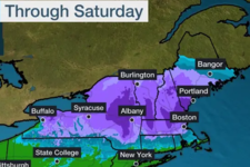
Recent Vermont forecast updates are showing a middle to lower VT target area for the most snowfall but 12"+ possible at most mountains by Saturday evening.


Last edited:
MidnightJester
Well-known member
- Joined
- Oct 7, 2011
- Messages
- 1,075
- Points
- 83
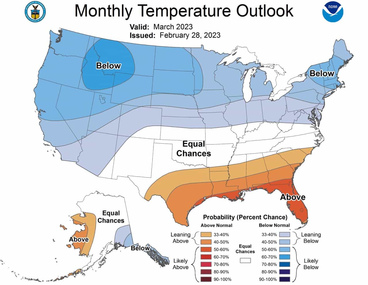
Winter is looking to try and make a comeback in the Northeast. A Late season snow push into spring will be appreciated bring on the Snow.

Similar threads
- Replies
- 953
- Views
- 146K
