• Welcome to AlpineZone, the largest online community of skiers and snowboarders in the Northeast!

    You may have to REGISTER before you can post. Registering is FREE, gets rid of the majority of advertisements, and lets you participate in giveaways and other AlpineZone events!

First Snowfalls, Upcoming weather and Storms of winter 2022-2023. Storm snow totals, Observations and Predictions?

zyk

Active member
Joined
Feb 10, 2010
Messages
418
Points
43
Right now southwest of Albany it is dumping snow and sleet. I'm only at 1200 feet. Higher elevations maybe all snow? I'm not going anywhere as cleanup with not be fun tomorrow.
 

Keelhauled

Active member
Joined
Dec 13, 2015
Messages
204
Points
28
Maybe it's tracking southerly again? If there doesn't start being less wind and more snow there will be a lot of disappointed people in northern VT in the morning.
 

Keelhauled

Active member
Joined
Dec 13, 2015
Messages
204
Points
28
Maybe it's tracking southerly again? If there doesn't start being less wind and more snow there will be a lot of disappointed people in northern VT in the morning.
Update: I can't see shit lol

JUilzOZ.jpg
 

MidnightJester

Active member
Joined
Oct 7, 2011
Messages
918
Points
43
It is still snowing throughout most of Vermont with upper mountain wind holds reported at multiple mountains as of 9am openings. Middle Vermont and Killington is already looking to be past the 12"+ opening snowfall today while northern VT seems to be lagging behind in snow totals so far but still in the 5"+ at most mountains up north as of 7am

Saturday 3/4/2023 opening trail numbers

Mount Snow --------- 73/86 (8"+ last 24hrs)
Okemo --------------- 121/126 (8"+ last 24hrs)
Stratton --------------- 99/99 (10"+ last 24hrs)
Killington -------------153/155 (14"+ last 24hrs)
Sugarbush ------------ 111/111 (10"-16"(summit) last 24hrs)
Stowe ----------------- 127/128 (5"+ last 24hrs)
Smugglers Notch -----77/78 (5"+ last 24hrs)
Jay Peak -------------- 81/81 (7"-9"+ last 24hrs)
 
Last edited:

MidnightJester

Active member
Joined
Oct 7, 2011
Messages
918
Points
43
Continuing the late Northeast's Winter push we have long range forecasts for next week and next weekend that have multiple possible snowmakers in the mix. Foot to foot and half accumulations are possible over the multiple days.

Current ski mountain season snow totals 3/7/2023

Mount Snow ---------96 inches
Okemo --------------- 121 inches
Stratton ---------------104 inches
Killington -------------153 inches
Sugarbush ------------147 inches
Stowe -----------------166 inches
Smugglers Notch -----162 inches
Jay Peak -------------- 287 inches total if true is a astounding difference from the rest of Vermont.

 
Last edited:

MidnightJester

Active member
Joined
Oct 7, 2011
Messages
918
Points
43
its fucking crazy that it took til march for consistent cold to stick around for more than a week
If next weeks snow comes through it will be 4 weeks and 3 week/weekends of straight decent snowstorms and best of season conditions all around. Got to pull off 3 days at Stowe last weekend and a Okemo & Mount Snow combo this Sunday & Monday both with stellar conditions.
 
Last edited:

ThatGuy

Well-known member
Joined
Feb 10, 2021
Messages
1,624
Points
113
Location
America
They’re basically in Canada so they could be using a meter stick and calling it inches 😂
 

MidnightJester

Active member
Joined
Oct 7, 2011
Messages
918
Points
43
I am liking that snow report. Its right to the point that snow is coming but it also tells you that the crowds will be DISTURBED by the snow the next day. I think Hunter mountain needs this "Disturbed" mountain disclaimer too for their special weekends
 
Last edited:

MidnightJester

Active member
Joined
Oct 7, 2011
Messages
918
Points
43

Late-week winter storm to precede potential nor’easter in the Northeast


Some of Upstate NY, Upstate NJ and Low Low VT might pick up a couple of inches of snow this Friday night into Saturday morning.
DCT_SPECIAL47_1280x720.jpg


Next week It is still looking like Mother Nature, Winter and Ullr are here for a little while more with a reliable 12" or more of SNOW over the beginning of the week with a two day storm system Monday into Tuesday night (Middle to Lower VT are the growing target area) but snow all around . Trailing behind this storm is another weather system that is looking to make next St. Paddy's day weekend refreshed with snow again on multiple days Friday night into Sunday 3/17-3/19 possible (6" again)

SnowmapNESunNtToTuesNtChan9Mar6p.jpg


Looking at long range temperature forecasts Vermont mountains are in a great temperature range if they wanted to make any Snow at night and even some early day time hours too. Wonder who will make any snow still?
 
Last edited:

Scottyskis2

Active member
Joined
Dec 17, 2022
Messages
433
Points
28
From mid Hudson Valley NY Facebook page snow forecast below:
::""
Fri PM/Sat AM Storm Update #2-

⚠️Increasing Snowfall Amounts⚠️

⤵️- Decreased Confidence

⏰Timing-
🟢 Starts- 6-9PM Friday
🛑 Stops- 10AM-1PM Saturday

💨Winds- Gusts 15-30MPH higher gusts south

📏Snowfall Amounts-
3”-6”+ within the blue zone
1”-4” within the red zone

💥 or 🎉- Boom or Bust- Higher end of forecast totals and even some localized higher amounts are possible. This boom scenario is what has cause us to increase our totals and take a bit of a risky stance on this storm. With that said- the forecast has become a bit volatile, will explain in the synopsis.

🤓Synopsis- Overnight we began to see some data point towards higher snowfall amounts across the region. Based on the setup of a low pressure decaying to our west and a offshore low taking over it seemed light a cut and dry forecast. The offshore low was moving away from the region and was to far offshore for any significant changes. We dug a bit deeper, image 1 is a projected surface map off the GFS, see how far offshore the low pressure is? Yet it’s still producing moderate snowfall across the region, which given its position is unlikely.

So why the increase is projected snowfall? The next image is a 500mb pressure map, what it’s showing is an ULL (Upper Level Low) moving south of the region at the same time as the previous image. An ULL can be a real wildcard in a winter storm, especially north of its track. An upper level low creates additional lift in the atmosphere, and can increase and expand precipitation rates and coverage. The final image is a vorticity map, which depicts lift in the atmosphere, also at the same time stamp as the previous images. As with any low pressure, the flow is counterclockwise, so you can see how the track of the ULL is enhancing precipitation and helping to drive moisture into the region from the exiting LP.

This is what both the GFS and Euro are sniffing since last night, historically ULL can create some surprises and can’t be trusted as they’ve ruined many forecasts. With that said, we’re gonna take a more aggressive stance on this one at the moment and get everyone ahead of the snowier potential. Keep us close on this one.

-Alex"""
 

MidnightJester

Active member
Joined
Oct 7, 2011
Messages
918
Points
43

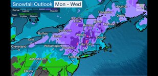
Next weeks Monday-Wednesday Snow storm and Nor'easter is coming into focus and is looking to be major snow dumper if it can slowly pass by and have a backside snow drop. Recent weather updates look like Middle to Lower VT are the major target areas in Vermont but snow all around. Here's to this SNOW storm "ULLR, ULLR, ULLR"
Screenshot_20230310-104442_The Weather Channel.jpg
Be "ahead or after" this storm cause Doing anything Tuesday is going to be a rough go or nightmare with Wednesday or Thursday being the day the Roads and mountains function and open somewhat properly I believe.
 
Last edited:

Kingslug20

Well-known member
Joined
Oct 14, 2021
Messages
2,506
Points
113
And come to think of it...I leave..it dumps..then dumps in France now for a week strait..they haven't gotten snow here for 1.5 months..now getting feet of it...now I'm coming home sunday..and a noreaster will hit...hmmm.
 
Top