• Welcome to AlpineZone, the largest online community of skiers and snowboarders in the Northeast!

    You may have to REGISTER before you can post. Registering is FREE, gets rid of the majority of advertisements, and lets you participate in giveaways and other AlpineZone events!

Killington 2016-7: It's On!

dlague

Active member
Joined
Nov 7, 2012
Messages
8,792
Points
36
Location
CS, Colorado
Didn't last year they open North Ridge for passholders and express card holders only?

yes on the first day

Exactly, they certainly are not going to leave North Ridge only to Pass Holder and Express Card holders until other terrain is available. They would miss out on the daily lift ticket frenzy. That often is the only terrain available for a couple to few weeks.
 

machski

Well-known member
Joined
Sep 5, 2014
Messages
3,935
Points
113
Location
Northwood, NH (Sunday River, ME)
At SR, there is a chance that they may open on Paradigm only using the Quantum Leap triple. They extended Paradigm's snowmaking line down to the lift and they were moving a ton of dirt off second mile around the peak lodge. Possibly regrading the runout of Peak Easy or a short cut behind the lodge to connect top of triple better to Paradigm? Time will tell i guess, but if so, a lot less terrain blow quick and open.
 

chuckstah

Well-known member
Joined
Mar 22, 2013
Messages
1,628
Points
83
North Ridge was pass holders only for a lot of early season last year. Not just opening day. They said the base couldn't handle more traffic. Than they closed for a couple weeks.
 

Jully

Active member
Joined
Dec 13, 2014
Messages
2,487
Points
38
Location
Boston, MA
Exactly, they certainly are not going to leave North Ridge only to Pass Holder and Express Card holders until other terrain is available. They would miss out on the daily lift ticket frenzy. That often is the only terrain available for a couple to few weeks.

Ahh, I was not quite sure what you meant. They certainly open to everyone on extremely limited terrain. Traditionally there has been one pass holders only day or, in the event of horrid weather like last year, multiple days when they first open due to a lack of base.
 

dlague

Active member
Joined
Nov 7, 2012
Messages
8,792
Points
36
Location
CS, Colorado
Ahh, I was not quite sure what you meant. They certainly open to everyone on extremely limited terrain. Traditionally there has been one pass holders only day or, in the event of horrid weather like last year, multiple days when they first open due to a lack of base.

We went last year when first open to the public and the only lift running was North Ridge an had to take the stairs back to the Gondola to get back down. It was a mad house which was expected based on past years.
 

Newpylong

Well-known member
Joined
Dec 20, 2005
Messages
5,313
Points
113
Location
Upper Valley, NH
I think even earlier personally. I would think Monday for passholders is totally doable.

No that is not doable if models remain true. Even Tuesday will be a stretch though I could see an afternoon for passholders then.
 
Last edited:

Jully

Active member
Joined
Dec 13, 2014
Messages
2,487
Points
38
Location
Boston, MA
No that is not doable if models remain true. Even Tuesday will be a stretch though I could see an afternoon for passholders then.

I have a window opening Saturday and continuing straight through Monday with a cold stretch of low 20s Saturday - Sunday night (like 19 - 23 degrees). Could be wrong but I thought they opened with a cold window roughly equivalent to that last year (shorter window but temperatures in the high teens at night).
 

ss20

Well-known member
Joined
Jan 13, 2013
Messages
3,989
Points
113
Location
A minute from the Alta exit off the I-15!
No that is not doable if models remain true. Even Tuesday will be a stretch though I could see an afternoon for passholders then.

Agreed. Saturday and Sunday will be ridiculously windy with marginal temps. Monday night and Tuesday night are going to be when the productivity happens.

I say Wednesday they'll be open to passholders, then Thursday-Friday open to the public, and then go back to passholders only for the weekend if they make it that long. Right now it looks like things will warm up with some rain starting Thursday.

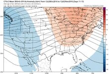
GFS long-term average for late Oct thru early November.

meh.jpg
 

Newpylong

Well-known member
Joined
Dec 20, 2005
Messages
5,313
Points
113
Location
Upper Valley, NH
I have a window opening Saturday and continuing straight through Monday with a cold stretch of low 20s Saturday - Sunday night (like 19 - 23 degrees). Could be wrong but I thought they opened with a cold window roughly equivalent to that last year (shorter window but temperatures in the high teens at night).

Marginal runs Sun and Monday AM at elevation with first good window Monday night. Monday is realistically not going to happen.
 
Last edited:

dlague

Active member
Joined
Nov 7, 2012
Messages
8,792
Points
36
Location
CS, Colorado
Agreed. Saturday and Sunday will be ridiculously windy with marginal temps. Monday night and Tuesday night are going to be when the productivity happens.

I say Wednesday they'll be open to passholders, then Thursday-Friday open to the public, and then go back to passholders only for the weekend if they make it that long. Right now it looks like things will warm up with some rain starting Thursday.

GFS long-term average for late Oct thru early November.

I have never seen them flip flop between pass holder days then to public then back to pass holders - I could be wrong. We have been skiing opening weekend since the stairs were in (2010) and I do not recall a flip flop unless there was a total warm up.

The Peak Walk

 
Last edited:

Smellytele

Well-known member
Joined
Jan 30, 2006
Messages
10,228
Points
113
Location
Right where I want to be
This is at 3400'
Saturday


Rain showers likely before 11am, then a chance of rain and snow showers between 11am and 2pm, then a chance of snow showers after 2pm. Cloudy, with a high near 40. Very windy, with a northwest wind 34 to 44 mph, with gusts as high as 55 mph. Chance of precipitation is 60%.

Saturday Night
A 40 percent chance of snow showers. Mostly cloudy, with a low around 26. Windy, with a west wind around 39 mph, with gusts as high as 49 mph.

Sunday
A chance of snow showers before 1pm, then a chance of rain and snow showers between 1pm and 3pm, then a chance of rain showers after 3pm. Partly sunny, with a high near 38. Very windy, with a west wind 34 to 41 mph, with gusts as high as 50 mph. Chance of precipitation is 30%.

Sunday Night
A chance of snow showers between 7pm and 8pm. Partly cloudy, with a low around 28. Very windy, with a northwest wind 45 to 55 mph decreasing to 34 to 44 mph after midnight. Winds could gust as high as 70 mph. Chance of precipitation is 30%.

Monday
A chance of rain and snow showers. Partly sunny, with a high near 37. West wind 13 to 18 mph becoming light and variable. Chance of precipitation is 30%.

Monday Night
A chance of rain and snow showers. Mostly cloudy, with a low around 24. Windy, with a north wind 24 to 30 mph. Chance of precipitation is 30%.
 

yeggous

Active member
Joined
Oct 8, 2012
Messages
2,170
Points
36
Location
Eagle, CO
This is at 3400'
Saturday


Rain showers likely before 11am, then a chance of rain and snow showers between 11am and 2pm, then a chance of snow showers after 2pm. Cloudy, with a high near 40. Very windy, with a northwest wind 34 to 44 mph, with gusts as high as 55 mph. Chance of precipitation is 60%.

Saturday Night
A 40 percent chance of snow showers. Mostly cloudy, with a low around 26. Windy, with a west wind around 39 mph, with gusts as high as 49 mph.

Sunday
A chance of snow showers before 1pm, then a chance of rain and snow showers between 1pm and 3pm, then a chance of rain showers after 3pm. Partly sunny, with a high near 38. Very windy, with a west wind 34 to 41 mph, with gusts as high as 50 mph. Chance of precipitation is 30%.

Sunday Night
A chance of snow showers between 7pm and 8pm. Partly cloudy, with a low around 28. Very windy, with a northwest wind 45 to 55 mph decreasing to 34 to 44 mph after midnight. Winds could gust as high as 70 mph. Chance of precipitation is 30%.

Monday
A chance of rain and snow showers. Partly sunny, with a high near 37. West wind 13 to 18 mph becoming light and variable. Chance of precipitation is 30%.

Monday Night
A chance of rain and snow showers. Mostly cloudy, with a low around 24. Windy, with a north wind 24 to 30 mph. Chance of precipitation is 30%.

No real surprise that as we get closer the models are starting to better resolve a series of shortwaves that ride along the boundary. The net result is more borderline temperatures and shorter windows. I remain skeptical that serious production will occur.
 

drjeff

Well-known member
Joined
Jan 18, 2006
Messages
19,403
Points
113
Location
Brooklyn, CT
No real surprise that as we get closer the models are starting to better resolve a series of shortwaves that ride along the boundary. The net result is more borderline temperatures and shorter windows. I remain skeptical that serious production will occur.

Bingo!

The literally constant chance of precip in that forecast means that the humidity levels are likely to be high across that time frame which won't help the wetbulb in those already marginal temps

Standard fall transitional weather pattern where temps tend to moderate as we get closer and humidity levels tend to fact in in an often detrimental way.

Hopefully the weather events this weekend will start the process of bringing in a true pattern change and make the Northern Component of the Jet stream with it's cooler, and often dryer air a more dominant player than it is now!
 

slatham

Well-known member
Joined
Sep 17, 2012
Messages
2,551
Points
113
Location
LI/Bromley
Bingo!

The literally constant chance of precip in that forecast means that the humidity levels are likely to be high across that time frame which won't help the wetbulb in those already marginal temps

Standard fall transitional weather pattern where temps tend to moderate as we get closer and humidity levels tend to fact in in an often detrimental way.

Hopefully the weather events this weekend will start the process of bringing in a true pattern change and make the Northern Component of the Jet stream with it's cooler, and often dryer air a more dominant player than it is now!

Its the days beyond the above forecast period that shows deeper and prolonged cold with dryer conditions. Of course that is beyond the extended and thus subject to change, but there has at least been consistency in the EURO and GFS seems to be getting onboard too......
 

Los

Active member
Joined
Jan 21, 2016
Messages
505
Points
28
Location
NH
My trusted sources (accuweather, ahem) predict low temps well above freezing in northern NH for most of November.

Regardless of its accuracy, it's not comforting.


Sent from my iPhone using AlpineZone
 

mriceyman

New member
Joined
Jan 4, 2012
Messages
1,344
Points
0
Location
cnj
Im looking at a warm oct-nov and hopeful of a pattern change early december


Sent from my iPhone using AlpineZone
 

Tin

Active member
Joined
Oct 14, 2009
Messages
2,996
Points
38
Location
ZooMass Slamherst
Since K cannot dust and run on Superstar and the depths have to be several feet minimum to install safety netting, any idea how much snowmaking they will have to do? I'm thinking weeks of a constant assault on SS.
 

Jully

Active member
Joined
Dec 13, 2014
Messages
2,487
Points
38
Location
Boston, MA
Since K cannot dust and run on Superstar and the depths have to be several feet minimum to install safety netting, any idea how much snowmaking they will have to do? I'm thinking weeks of a constant assault on SS.

I've heard 5 feet or so of depth I think. They have the exact number of hours approximated though i forget the exact number. Might be 96?
 

chuckstah

Well-known member
Joined
Mar 22, 2013
Messages
1,628
Points
83
They will be hammering SS when the temps drop Saturday. I think I heard 144 non consecutive hours of snow making will be requured for the race. I hope they let the public ski SS for a few days during snowmaking once a base is down.
 
Top