-
Welcome to AlpineZone, the largest online community of skiers and snowboarders in the Northeast!
You may have to REGISTER before you can post. Registering is FREE, gets rid of the majority of advertisements, and lets you participate in giveaways and other AlpineZone events!
You are using an out of date browser. It may not display this or other websites correctly.
You should upgrade or use an alternative browser.
You should upgrade or use an alternative browser.
Long Range NorEaster
- Thread starter Abubob
- Start date
BenedictGomez
Well-known member
Keep in mind this is still over a week and a half away.
Still fun to look at! Plus, it seems to be projecting a bit colder than originally. Incremental positives!
Abubob
Well-known member
Abubob
Well-known member
BenedictGomez
Well-known member
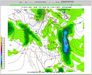
GFS refuses to back down, still showing a decent NY/NE snow for 11/28'ish.
ScottySkis
Well-known member
GFS refuses to back down, still showing a decent NY/NE snow for 11/28'ish.
Sent from my ADR6410LVW using Tapatalk 2
I hope the hills get some to.
BenedictGomez
Well-known member
I hope the hills get some to.
It's just a model run, so nothing to get excited about yet, but Platty is in the 5-6 inch range on it. I'm just excited to "see" snow, even if it's only on a model!
It's just a model run, so nothing to get excited about yet, but Platty is in the 5-6 inch range on it. I'm just excited to "see" snow, even if it's only on a model!
I'm leaning towards that track getting pulled back a bit further west to fit more in with this model's bias. Maybe a bit more front-end mixing. But at least temps drop this weekend so northeast resorts can go all-out snowmaking. That would mean some good lake effect snows for you Scotty!
Abubob
Well-known member
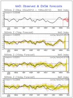
The GFS seems to be mirroring the MRF ensembles ambiguity but there's an indication that the NAO will be on the negative side if not more so. That's what this storm needs to deepen into a bigger storm rather than just continuing on out to sea.
One other thing to note is that GFS shows three separate weather events for the Northeast inside of a week from Wed Nov 28 to Wed Dec 5. SOMETHING's gonna happen!
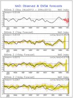
One other thing to note is that GFS shows three separate weather events for the Northeast inside of a week from Wed Nov 28 to Wed Dec 5. SOMETHING's gonna happen!

Last edited:
ScottySkis
Well-known member
I'm leaning towards that track getting pulled back a bit further west to fit more in with this model's bias. Maybe a bit more front-end mixing. But at least temps drop this weekend so northeast resorts can go all-out snowmaking. That would mean some good lake effect snows for you Scotty!
That would be about as much lake effect as they got last year.
The GFS seems to be mirroring the MRF ensembles ambiguity but there's an indication that the NAO will be on the negative side if not more so. That's what this storm needs to deepen into a bigger storm rather than just continuing on out to sea.
One other thing to note is that GFS shows three separate weather events for the Northeast inside of a week from Wed Nov 28 to Wed Dec 5. SOMETHING's gonna happen!
True, the NAO will be slightly negative which helps--after all, it'll be just about as negative as it was for last year's Snowtober storm--however, the transition to negative is weak during that time. I'd rather see it sort of snap into negative rather than go negative then flatline to the event. I can see a slightly weakened system sliding through rather than bombing out offshore. Another indication is the near flat flow across the US leading up to the event. The upper level trough, or short-wave (looking at the 500 milibar chart on both the GFS and Euro) slides straight across from the Midwest to New England. Probably too flat to get a strong storm--I'd like to see that curl in much further south.
I'm not trying to poo-poo what you're saying--I'm just offering a fun exercise in considering a few more variables. Yes, something will be brewing as colder air tries to edge in....probably a quick half-foot (give or take) event with a slider like this. It'll be fun to track over the holiday!
Thanks Abubob!
Abubob
Well-known member
True, the NAO will be slightly negative which helps--after all, it'll be just about as negative as it was for last year's Snowtober storm--however, the transition to negative is weak during that time. I'd rather see it sort of snap into negative rather than go negative then flatline to the event. I can see a slightly weakened system sliding through rather than bombing out offshore. Another indication is the near flat flow across the US leading up to the event. The upper level trough, or short-wave (looking at the 500 milibar chart on both the GFS and Euro) slides straight across from the Midwest to New England. Probably too flat to get a strong storm--I'd like to see that curl in much further south.
I'm not trying to poo-poo what you're saying--I'm just offering a fun exercise in considering a few more variables. Yes, something will be brewing as colder air tries to edge in....probably a quick half-foot (give or take) event with a slider like this. It'll be fun to track over the holiday!
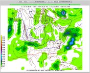
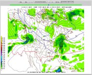
Not to be negative but its looking more and more like the NAO will be. The GFS is showing more "curl" here - maybe too much as the low is forming over land which could circulate the warm air in first but its still showing this as a big storm.
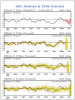
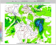
Not to be negative but its looking more and more like the NAO will be. The GFS is showing more "curl" here - maybe too much as the low is forming over land which could circulate the warm air in first but its still showing this as a big storm.
View attachment 6875 View attachment 6876
Another thing to keep in mind is the model run....off-hour runs like the 06 and 18Z are run off of old data....the 00Z and 12Z runs ingest new upper air sounding data. Try to compare the on-hour runs to off-hour runs to keep track of those changes. Just another thing to consider. We'll be watching the potential for the track to shift back a bit with some mixing with this. Still a ways out--plenty of time to soak in more data!
Abubob
Well-known member
Another thing to keep in mind is the model run....off-hour runs like the 06 and 18Z are run off of old data....the 00Z and 12Z runs ingest new upper air sounding data. Try to compare the on-hour runs to off-hour runs to keep track of those changes. Just another thing to consider. We'll be watching the potential for the track to shift back a bit with some mixing with this. Still a ways out--plenty of time to soak in more data!
True that. I just like to post the ones that look like big snow. Reality will always tend to muck things up though. 8)
ScottySkis
Well-known member
Another thing to keep in mind is the model run....off-hour runs like the 06 and 18Z are run off of old data....the 00Z and 12Z runs ingest new upper air sounding data. Try to compare the on-hour runs to off-hour runs to keep track of those changes. Just another thing to consider. We'll be watching the potential for the track to shift back a bit with some mixing with this. Still a ways out--plenty of time to soak in more data!
Still looking good for lake effect snow next week and a snow storm for the Catskills?
True that. I just like to post the ones that look like big snow. Reality will always tend to muck things up though. 8)
I hear ya! It's always good to track those from a long ways out like you're doing just to see the trend. The 12Z runs were interesting--Euro too. I haven't looked at much nor the ensembles but it does look a bit more interesting. Now let's monitor this trend to see how it hangs on to this solution. I'll be busy the rest of the day--if I don't catch up with you before then, Happy Thanksgiving!
Still looking good for lake effect snow next week and a snow storm for the Catskills?
Some stretched out lake effect Saturday is still in the cards. Still watching next week's storm--a favorable trend but will monitor over the holiday/weekend. Happy Thanksgiving if i don't catch up with you til then.
Abubob
Well-known member
ScottySkis
Well-known member
Sent from my ADR6410LVW using Tapatalk 2
So not much snow for the hills is south New England from the snow event on this Saturday night?
So not much snow for the hills is south New England from the snow event on this Saturday night?
Abubob
Well-known member
Sent from my ADR6410LVW using Tapatalk 2
So not much snow for the hills is south New England from the snow event on this Saturday night?
We were getting snow showers here is central NH this evening. How much did central NY state get Scotty?
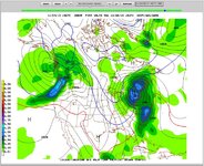
As far as the "event" for Wednesday is concerned there seems to be no way to predict what track it will take. It seems it will definitely go out over water but - how far south or north? Too far south and it just goes out to sea. Still hoping but the cold air that we need so desperately is working against us but pushing the storm too far south. There's new hope for the 6th though. :dunce:
Similar threads
- Replies
- 14
- Views
- 4K
