• Welcome to AlpineZone, the largest online community of skiers and snowboarders in the Northeast!

    You may have to REGISTER before you can post. Registering is FREE, gets rid of the majority of advertisements, and lets you participate in giveaways and other AlpineZone events!

NWS 2016 / 2017 Winter forecast!

Tin

Active member
Joined
Oct 14, 2009
Messages
2,996
Points
38
Location
ZooMass Slamherst
Through Monday evening. Skeptical if they will really get that much.


IMG_3733.PNG.793287402fbda5ece2158765c96533b2.PNG
 

benski

Active member
Joined
Jun 18, 2014
Messages
1,116
Points
36
Location
Binghamton NY
Through Monday evening. Skeptical if they will really get that much.


IMG_3733.PNG.793287402fbda5ece2158765c96533b2.PNG

I hope so. Looks like Snow Ridge is getting hammered. Hoping to go there for the first time weekend after Thanksgiving, I am glad this message board turned me onto that place. I am getting so excited!
 

Cornhead

Well-known member
Joined
Dec 4, 2010
Messages
2,840
Points
48
I hope so. Looks like Snow Ridge is getting hammered. Hoping to go there for the first time weekend after Thanksgiving, I am glad this message board turned me onto that place. I am getting so excited!
Don't get too excited, it is only 500ft of vert, sometimes you might even get stuck! We go there regularly, sorry I haven't replied to your PM's, I don't check them often. Send me your number I'll let you know next time we go. Looks like they may get 10-20" out of this one. My buddy is talking about earning turns at Song if they get enough. I'm not skiing till Friday, K or possibly somewhere else.

Check Liftopia for deals at SR, we used to get half off with our Greek passes, not anymore. Still pretty cheap though.

Sent from my XT1064 using AlpineZone mobile app
 

benski

Active member
Joined
Jun 18, 2014
Messages
1,116
Points
36
Location
Binghamton NY
Don't get too excited, it is only 500ft of vert, sometimes you might even get stuck! We go there regularly, sorry I haven't replied to your PM's, I don't check them often. Send me your number I'll let you know next time we go. Looks like they may get 10-20" out of this one. My buddy is talking about earning turns at Song if they get enough. I'm not skiing till Friday, K or possibly somewhere else.

Check Liftopia for deals at SR, we used to get half off with our Greek passes, not anymore. Still pretty cheap though.

Sent from my XT1064 using AlpineZone mobile app

I thought you blocked pm's to be honest. they were missing from my sent pm's
 

jack97

New member
Joined
Mar 4, 2006
Messages
2,513
Points
0
Weird stuff going on up in the Arctic with record warmth. Over in Siberia there still is that cold air. How will the jet stream bend and will the cold come down to the NE? My guess is that in January this becomes apparent. Atlantic Ocean off the house is still pretty warm.

The GFS is showing the cold temps rolling in next week, the week of Thanksgiving and staying till the first week of Dec (per the last of its data runs). Long range forecasters are using other indices and altitude maps which show this pattern will stay for Dec.

As for Arctic warmth and the Siberian snow cover, Cohen writes about this in the attached. Essentially, the fall season snow cover results in an albedo which reflects the sun light. This causes the warm air mass to move up and forms the Siberian high (pressure). This high alters (weakens) the polar vortex such that the lower latitudes will get colder surface temps. Cohen talks about this in more detail, the key point in his hypothesis is the formation of the Siberian high during the fall.

http://www.nws.noaa.gov/ost/climate/STIP/FY11CTBSeminars/jcohen_062211.pdf
 
Last edited:

slatham

Well-known member
Joined
Sep 17, 2012
Messages
2,549
Points
113
Location
LI/Bromley
Weatherbell is very bullish for this to be a December to remember and the longer range models and teleconnections are lending significant support finally. Not to mention the actual weather is turning - which in the Northeast looks to happen in about 14 hours wth winter storm watches and warnings hoisted.
 

jack97

New member
Joined
Mar 4, 2006
Messages
2,513
Points
0
Weatherbell is very bullish for this to be a December to remember and the longer range models and teleconnections are lending significant support finally.
Speaking of teleconnections, here's the AO since 1950 to present, the current belief is the timing of when the AO goes negative which sets up the winter. Last season, iirc, around feb/march the bumps where frozen cement and we had a weekend with wind chill advisory (forgot when tho). Jan and Feb of this year, the index went negative. I remember Cohen posting that when it went negative.

http://www.cpc.ncep.noaa.gov/produc...ndex/monthly.ao.index.b50.current.ascii.table


btw, here's the web page of gfs forecast, if it holds Nov is trending negative.

http://www.cpc.ncep.noaa.gov/products/precip/CWlink/daily_ao_index/ao_index_mrf.shtml
 
Last edited:

Cornhead

Well-known member
Joined
Dec 4, 2010
Messages
2,840
Points
48
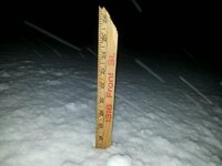
This was 7PM at our local defunct ski hill, Aqua Terra, formerly Innsbruck USA.
1479698291505.jpg
Looks like we're in the bullseye, gonna earn a run or two after work tomorrow.
13f78e9bb0ccdcd73090162f89d26633.jpg


Sent from my XT1064 using AlpineZone mobile app
 

Cornhead

Well-known member
Joined
Dec 4, 2010
Messages
2,840
Points
48
ACCUMULATIONS, ADDITIONAL 4 TO 8 INCHES OF SNOW TODAY, HEAVIEST
THIS MORNING, BRINGING STORM TOTALS UP TO 10 TO 20 INCHES

Sent from my XT1064 using AlpineZone mobile app
 

dlague

Active member
Joined
Nov 7, 2012
Messages
8,792
Points
36
Location
CS, Colorado
Good to see some of these amounts. The start of this season for the northeast seems to be better than the months of February or March. Not so much here in Colorado, but there is a pattern setting up that might work out well.

Sent from my SM-G930P using AlpineZone mobile app
 
Top