jack97
New member
- Joined
- Mar 4, 2006
- Messages
- 2,513
- Points
- 0
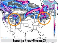
The "promise" of the change in pattern was based on very some skilled long range forecasting techniques. I don't trust the GFS over one week out but things look promising.
Welcome to AlpineZone, the largest online community of skiers and snowboarders in the Northeast!
You may have to REGISTER before you can post. Registering is FREE, gets rid of the majority of advertisements, and lets you participate in giveaways and other AlpineZone events!
You mean on the ground in the mountains? Or actively falling from the sky in the flatlands?
Sent from my iPhone using AlpineZone mobile app

And it looks like this is a map from Weatherbell!
They are right that its a major shift from what we've seen but its a bit of hype. Then again they are the media......

Killington has been open for 20 days or so.....go get itRight, that was my only point...
But whatever... I just want to go skiing already.

So he mountains here in CO got about 6-8 inches, the Front Range even got snow! Colorado Springs got 2 so far. This system is winding down but headed up towards the Great Lakes then over to New England. Looks to start as rain then switch to snow. There are two other systems right behind this one for Colorado over the next week. Hopefully they track the same and bring the goods to New England too!
Things are starting to look up!
