• Welcome to AlpineZone, the largest online community of skiers and snowboarders in the Northeast!

    You may have to REGISTER before you can post. Registering is FREE, gets rid of the majority of advertisements, and lets you participate in giveaways and other AlpineZone events!

The 01/22 - 01/23 Storm thread (Could a snowstorm actully hit the Poconos?)

BenedictGomez

Well-known member
Joined
Jan 26, 2011
Messages
12,545
Points
113
Location
Wasatch Back
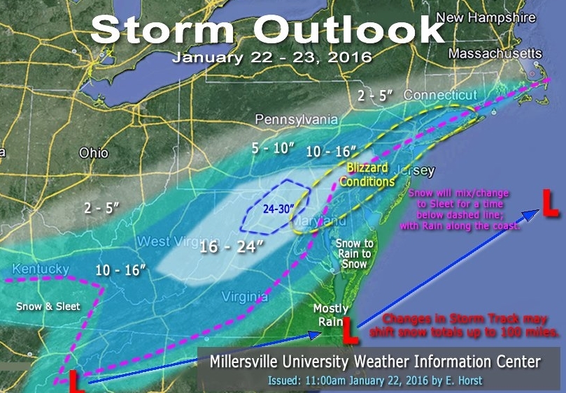
Mappage predictions, because we all love those....

12492015_974116979302227_8410000575356872865_o.jpg
 

BenedictGomez

Well-known member
Joined
Jan 26, 2011
Messages
12,545
Points
113
Location
Wasatch Back
NAM model still showing a solution off by literally hundreds of miles. When the NAM busts hard on this storm, it's going to be a MAJOR embarrassment that the US governments SHORT RANGE model was beaten by literally every global LONG RANGE model, on a storm that's < 12 hours from our doorstep. [/rant off]

12493841_1028246133885639_1005968271702290614_o.png
 

BenedictGomez

Well-known member
Joined
Jan 26, 2011
Messages
12,545
Points
113
Location
Wasatch Back
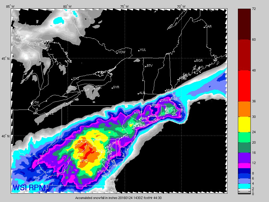
12z GFS goes NORTH!!!!!!

To my eye, that looks like 8" to 10" for Blue Mountain, but the huge snow totals are knocking on the door and only require another 20 mile shift.

snowfall_total_accum_10to1_NECONUS_hr042.png


Versus GFS ensembles that just finished. OP is a juicy outlier, but ensembles still about 7" to 9" for Blue Mountain.

snowfall_total_accum_10to1_NECONUS_hr048.png
 
Last edited:

jimk

Well-known member
Joined
Sep 1, 2012
Messages
1,866
Points
113
Location
Wash DC area
I am currently at Canaan Valley Lodge, WV. They got about 4" last night. Calling for 4-8' tomorrow afternoon and 11-17" more Fri night into Saturday. I'll post some photos when it gets good. I'm scheduled to head home to DC area on Sunday afternoon unless the roads are closed. Bring it on, just don't kill the power lines to the chair lifts! :)

i'LL start separate thread later, but here's some quick photos and info from this AM in WV, got to get back to the hill now. Dumping underway:
http://www.dcski.com/forum/86087&scrollto=86087
 

BenedictGomez

Well-known member
Joined
Jan 26, 2011
Messages
12,545
Points
113
Location
Wasatch Back
Euro makes another slight northward move!

All we need is another 20 miles north and the Poconos gets 12" for sure.

12508863_10153953155481742_3444155265706865849_n.jpg
 

Bene288

New member
Joined
Nov 25, 2011
Messages
1,026
Points
0
Location
Albany, NY
So Blue Mt will make out it looks like? Have family in NJ and thinking of traveling down in the 4x4 tomorrow to ski Sunday. I'm guessing even with 12" skiing the trees wouldn't be advisable given the base?
 

Tin

Active member
Joined
Oct 14, 2009
Messages
2,996
Points
38
Location
ZooMass Slamherst
Really hoping the NAM and others are on it. NWS Boston is upping advisories and warnings for southern New England...Maybe? Just maybe?

This could be quite the shocker of a system...


CZWeaB-WEAAoITj.jpg
 

Rowsdower

Member
Joined
Dec 16, 2013
Messages
818
Points
18
Location
Upper Bucks/Lehigh Valley, PA
So Blue Mt will make out it looks like? Have family in NJ and thinking of traveling down in the 4x4 tomorrow to ski Sunday. I'm guessing even with 12" skiing the trees wouldn't be advisable given the base?

There is literally zero base so I wouldn't advise it. Blue does have a small maintained gladed area, so maybe that will be in play.
 

abc

Well-known member
Joined
Mar 2, 2008
Messages
5,935
Points
113
Location
Lower Hudson Valley
Really hoping the NAM and others are on it. NWS Boston is upping advisories and warnings for southern New England...Maybe? Just maybe?

This could be quite the shocker of a system...
It maybe my wishful thinking. But it seems the storm is coming up earlier than predicted. (I'm in my office in NYC. Prediction is for snow to start after mid-night. But from the map, it looks like it may start in the next couple of hours!)

Perhaps that's confirming a more northerly trend than the prediction?
 

Not Sure

Well-known member
Joined
Dec 14, 2013
Messages
2,859
Points
63
Location
Lehigh County Pa.
Website
www.youtube.com
It maybe my wishful thinking. But it seems the storm is coming up earlier than predicted. (I'm in my office in NYC. Prediction is for snow to start after mid-night. But from the map, it looks like it may start in the next couple of hours!)

Perhaps that's confirming a more northerly trend than the prediction?

Lots of Virga , Not Sowing here in Pa. yet but radar seeing snow. Falling through very dry air and evaporating.
 
Top