• Welcome to AlpineZone, the largest online community of skiers and snowboarders in the Northeast!

    You may have to REGISTER before you can post. Registering is FREE, gets rid of the majority of advertisements, and lets you participate in giveaways and other AlpineZone events!

The Official 3/2 Storm Discussion Thread

awf170

New member
Joined
Jan 28, 2005
Messages
4,380
Points
0
Location
Lynn and Lowell MA
The sleet is going to hit everywhere. Just watch. You might be able to avoid it at Sugarloaf, Saddleback, and Jay, but I still wouldn't be surprised if they got some too. I'm not trying to be negative but weatherman always underestimate the power of warm air over-riding.

Sleet makes a good base!
 

hammer

Active member
Joined
Apr 28, 2004
Messages
5,493
Points
38
Location
flatlands of Mass.
Just looked at the latest radar...whatever we get, it's going to be a lot of precip:

usa_None_anim.gif
 

JimG.

Moderator
Staff member
Moderator
Joined
Oct 29, 2004
Messages
12,106
Points
113
Location
Hopewell Jct., NY
The sleet is going to hit everywhere. Just watch. You might be able to avoid it at Sugarloaf, Saddleback, and Jay, but I still wouldn't be surprised if they got some too. I'm not trying to be negative but weatherman always underestimate the power of warm air over-riding.

Sleet makes a good base!

Killjoy! You're just jealous. I'm loving King's post.

I called this deal a few weeks ago and have been telling folks that the time to hit the MRV is when I go up there...my last 3 trips there have yielded tons of snow and this one looks like it might be the grandaddy of them all.

Swwwwwwwweeeeeeeeeeeeeeeeeeeet!
 

KingM

New member
Joined
Dec 30, 2004
Messages
977
Points
0
Location
Warren, VT (Sugarbush, MRG)
Website
www.goldenlionriversideinn.com
Killjoy! You're just jealous. I'm loving King's post.

I called this deal a few weeks ago and have been telling folks that the time to hit the MRV is when I go up there...my last 3 trips there have yielded tons of snow and this one looks like it might be the grandaddy of them all.

Swwwwwwwweeeeeeeeeeeeeeeeeeeet!

And if people had just paid attention, I wouldn't be turning away people right and left who are trying to storm chase a little too late. It's not as bad as President's Weekend, but there are still a lot of people who would like to come, but can't.

Your only bad timing Jim is that you're coming tomorrow instead of tonight. Drive carefully, please. The roads might still be interesting on Friday night.
 

riverc0il

New member
Joined
Jul 10, 2001
Messages
13,039
Points
0
Location
Ashland, NH
Website
www.thesnowway.com
lol, austin. i'll be dodging sleet for a few hours in between the 1-2 feet of fresh snow, heh! it isn't freezing rain or NCP, so it doesn't matter. just stings the face a bit while skiing and encourages skiers to slow down :)
 

thetrailboss

Moderator
Staff member
Moderator
Joined
Jun 4, 2004
Messages
33,124
Points
113
Location
NEK by Birth
The latest from NWS. Snow totals are not as good as they were this AM :-? We'll see what we get....

For Killington:
/O.CON.KBTV.WS.W.0003.070302T0500Z- 070303T0200Z/ WESTERN RUTLAND-WINDSOR- EASTERN RUTLAND- INCLUDING THE CITIES OF...RUTLAND...SPRINGFIELD... WHITE RIVER JUNCTION...EAST WALLINGFORD... KILLINGTON 347 PM EST THU MAR 1 2007

...WINTER STORM WARNING REMAINS IN EFFECT FROM MIDNIGHT TONIGHT TO 9 PM EST FRIDAY...

A WINTER STORM WARNING REMAINS IN EFFECT FROM MIDNIGHT TONIGHT TO 9 PM EST FRIDAY.

SNOW IS EXPECTED TO DEVELOP BETWEEN 10 PM AND MIDNIGHT TONIGHT... WITH 3 TO 5 INCHES OF SNOWFALL EXPECTED BY DAYBREAK ON FRIDAY. SNOW WILL CHANGE TO INTERMITTENT PERIODS OF SLEET STARTING AROUND 7 AM. PERIODS OF SLEET AND A CHANCE OF FREEZING RAIN WILL PERSIST THROUGHOUT THE DAY ON FRIDAY. ADDITIONAL SNOW AND SLEET ACCUMULATIONS WILL RANGE FROM 1 TO 3 INCHES...MAINLY WITH ANY WRAP AROUND SNOW OCCURRING DURING THE LATE AFTERNOON OR EARLY EVENING. TRAVEL CONDITIONS WILL LIKELY BE AT THEIR WORST AROUND THE MORNING COMMUTE...AND AGAIN AT THE EVENING COMMUTE WITH A FINAL BURST OF HEAVY SNOW POSSIBLE FROM LATE AFTERNOON INTO EARLY EVENING.

TOTAL SNOW AND SLEET ACCUMULATION WITH THIS SYSTEM IS EXPECTED TO RANGE FROM 4 TO 8 INCHES ACROSS SOUTH CENTRAL VERMONT THROUGH FRIDAY EVENING. SOME LIGHT ICE ACCUMULATION IS ALSO POSSIBLE.

PERSONS ACROSS NORTHERN NEW YORK AND VERMONT...SHOULD TAKE THE NECESSARY ACTION AND PREPARE FOR THIS UPCOMING WINTER STORM. IF TRAVELING TOMORROW... BE PREPARED FOR POOR TRACTION IN SNOW... SLEET...AND POSSIBLE LIGHT ICE ACCUMULATIONS ON ROADWAYS. WITH DEEP SNOW COVER ON THE GROUND...ENSURE THAT ANY OUTDOOR FURNACE VENTS REMAIN CLEAR OF SNOW AND SLEET ACCUMULATION.

For Northern Vermont:

/O.CON.KBTV.WS.W.0003.070302T0500Z- 070303T0200Z/ ORLEANS-ESSEX-LAMOILLE- CALEDONIA-WASHINGTON-ORANGE- EASTERN FRANKLIN-EASTERN CHITTENDEN-EASTERN ADDISON- INCLUDING THE CITIES OF... NEWPORT...ISLAND POND...JOHNSON... STOWE...ST. JOHNSBURY...MONTPELIER... BRADFORD...RANDOLPH... ENOSBURG FALLS...RICHFORD...UNDERHILL... BRISTOL...RIPTON 347 PM EST THU MAR 1 2007

...WINTER STORM WARNING REMAINS IN EFFECT FROM MIDNIGHT TONIGHT TO 9 PM EST FRIDAY...

A WINTER STORM WARNING REMAINS IN EFFECT FROM MIDNIGHT TONIGHT TO 9 PM EST FRIDAY.

SNOW IS EXPECTED TO DEVELOP ACROSS NORTH CENTRAL AND NORTHEAST VERMONT... INCLUDING THE WESTERN SLOPES OF THE GREEN MOUNTAINS JUST AFTER MIDNIGHT TONIGHT...WITH 3 TO 5 INCHES OF SNOWFALL EXPECTED BY 8 AM FRIDAY. BY 10 AM...SNOW WILL CHANGE TO INTERMITTENT PERIODS OF SLEET...AND POSSIBLE FREEZING DRIZZLE OR LIGHT FREEZING RAIN THROUGH LATE AFTERNOON. THIS WILL LIMIT ADDITIONAL ACCUMULATIONS THROUGH MUCH OF THE DAY FRIDAY. DURING THE LATE AFTERNOON INTO EARLY EVENING...A FINAL BURST OF HEAVY SNOW WILL OCCUR FOR A FEW HOURS... YIELDING AN ADDITIONAL 2 TO 5 INCHES OF SNOW. PRECIPITATION WILL TAPER OFF TO SNOW SHOWERS BY LATE FRIDAY EVENING.

TOTAL SNOW AND SLEET ACCUMULATION WITH THIS SYSTEM IS EXPECTED TO RANGE FROM 5 TO 10 INCHES FROM THE WEST SLOPES OF THE GREEN MOUNTAINS...EASTWARD ACROSS CENTRAL AND NORTHEAST VERMONT. THE HIGHER TOTALS WILL OCCUR AWAY FROM THE UPPER CONNECTICUT AND LOWER PASSUMPSIC RIVER VALLEYS. THE WORST TRAVEL CONDITIONS WILL LIKELY OCCUR AROUND THE MORNING COMMUTE...AND AGAIN WITH THE FINAL BURST OF HEAVY SNOW NEAR THE EVENING COMMUTE.

PERSONS ACROSS NORTHERN NEW YORK AND VERMONT...SHOULD TAKE THE NECESSARY ACTION AND PREPARE FOR THIS UPCOMING WINTER STORM. IF TRAVELING TOMORROW... BE PREPARED FOR POOR TRACTION IN SNOW... SLEET...AND POSSIBLE LIGHT ICE ACCUMULATIONS ON ROADWAYS. WITH DEEP SNOW COVER ON THE GROUND...ENSURE THAT ANY OUTDOOR FURNACE VENTS REMAIN CLEAR OF SNOW AND SLEET ACCUMULATION.
 

Greg

Moderator
Staff member
Moderator
Joined
Jul 1, 2001
Messages
31,154
Points
0
Could we do 2-3 feet over the next 5 days - absolutely yes !!!
The better part of this situation continues to be the set-up in the aftermath of Friday. We have Friday evening where another round of snow will likely bring a few inches to the mountain. On Saturday however the dyanmics arrive and the terrain snow machine will kick into high gear. There will be undulations in the intensity of the snow and it will be hard to predict specific amounts each day. One period where the snow might become intense is Saturday afternoon and evening. Most importantly though is that the snow should continue in sporadic but at times intense fashion in the period beginning Saturday and ending Tuesday. When you the Saturday-Tuesday amounts with Friday's amounts 2-3 feet is a very reasonable guess. Be aware however that valley locations will see snow mainly on Friday and the limited sunshine on Saturday, Sunday and Monday could send temperatures in the Champlain Valley to near 40. It will be a lot different though in the high country and a lot better for skiing.

Nice! And KingM - we expect constant reports and pics on how you do in the valley...
 

snowmonster

New member
Joined
Jan 2, 2006
Messages
4,066
Points
0
Location
In my mind, northern New England
Got this from Sunday River. Could be true. Could be marketing hype. But, I've convinced the li'l snowmonster to ditch our planned trip to New Jersey so we're headed to Maine this weekend. Sweet!

--------------------------------

We just couldn't wait to tell you about this
one...we've got a blockbuster storm headed our
way and we're right in the bullseye. Forecasts
are calling for heavy snow all day Friday, with
18-24" expected when it's all said and done.
Post-storm weather looks nice too with temps
up to the high 30s, so you've got no excuses for
not going out this weekend. Remember how epic the
Valentine's Day storm was? This storm is going
to make conditions epic squared.

xxx

Keep an eye on the snow report and we'll keep
you posted!

Jessie
Team Snow
 

awf170

New member
Joined
Jan 28, 2005
Messages
4,380
Points
0
Location
Lynn and Lowell MA
lol, austin. i'll be dodging sleet for a few hours in between the 1-2 feet of fresh snow, heh! it isn't freezing rain or NCP, so it doesn't matter. just stings the face a bit while skiing and encourages skiers to slow down :)

Good job trying to jinx the storm. :angry:

I heard it won't sleet if you go to Cannon on Sunday though...
 

Tin Woodsman

Well-known member
Joined
Jul 12, 2004
Messages
1,146
Points
63
The sleet is going to hit everywhere. Just watch. You might be able to avoid it at Sugarloaf, Saddleback, and Jay, but I still wouldn't be surprised if they got some too. I'm not trying to be negative but weatherman always underestimate the power of warm air over-riding.

Sleet makes a good base!

I'm afraid I have to agree, based on everything I've read. My heart remains with Josh, but every other source has indicated that the models are going warmer than previously forecasted. Josh must be focused purely on the NAM, which is an outlier from what I've seen.

As for the sleet - we don't need the base. We've GOT the base. We need some fluffy snow to freshen up the windbuffed snow surfaces.
 

MikeTrainor

Member
Joined
Jan 9, 2006
Messages
356
Points
18
Location
MA
And if people had just paid attention, I wouldn't be turning away people right and left who are trying to storm chase a little too late. It's not as bad as President's Weekend, but there are still a lot of people who would like to come, but can't.

Your only bad timing Jim is that you're coming tomorrow instead of tonight. Drive carefully, please. The roads might still be interesting on Friday night.

Glad I booked ahead then, should be a great weekend! Keep us updated tomorrow...
 

powderfreak

New member
Joined
Jan 9, 2007
Messages
256
Points
0
I'm sorry for not getting on this earlier but have been too busy skiing and working. The last 5 or 6 days have showed me what life should be about. Now I'm left catching up here on the details but have had a general idea in my head since yesterday. The details that are important for skiing and riding this weekend...

-It will change to sleet or at least mix with sleet all the way to the Canadian border, except in ME and possibly far northern NH. Those areas will be furthest away from the warm layer, which will move into other regions from the SSW. Models can't make up their mind but they almost always under-predict the northward extent of the warm air.

-Winds will be very strong tomorrow morning out of the south. Wind holds are likely on some lifts. Winds look to be fine for Saturday and Sunday. No problems expected.

-A wall of snow is expected to move into the region in the early morning hours. It should be snowing in Burlington by 5am and be steady at 1"/hr. Only 1-3" on the ground at daybreak.

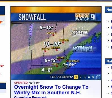
TOTAL ACCUMULATIONS...will be 7-14" from SB/MRG northward through Jay Peak in VT, in the northeastern Adirondacks of NY, the northern half of NH, most of ME except maybe coastal sections. Highest totals will be in NH and ME where some spots could see over 14". Lowest totals will be across central VT and the northeastern Adirondacks where I expect more mixing...but if that does not come true, then over a foot of snowfall is likely. South of there, near a Gore-Killington-Sunapee line, 4-8" with sleet, and possibly freezing rain, will fall through Friday night. New snow might have a crust layer. In the Catskills, Berkshires, and southern VT...expect 2-6" with the 5-6" amounts falling in the Berkshires and southern VT. Only a couple inches is expected at Catskill ski areas before significant icing. Heavy sleet and/or freezing rain accumulations are also possible in S.VT, and the Berkshires on top of the snowfall.

Sorry about the time and its not as in-depth as I'd like, but I'm going to be following this storm now as it evolves and will post thoughts.

-Scott
 

ctski

New member
Joined
Jan 2, 2007
Messages
7
Points
0
man, up here in Burlington, we are getting different reports hourly. i've heard anywhere from two inches to two feet tomorrow. i've also heard sleet (please, no...)
 

Goblin84

New member
Joined
Dec 25, 2006
Messages
452
Points
0
Location
Canton, NY
the question then comes..... I have a snowday tomorrow ( i love working in education)... should I not ski? Or goto Cannon, gunstock, or sunapee where i have passes too?
 

aveski2000

Member
Joined
Nov 23, 2006
Messages
210
Points
16
Location
Auburn ME
It looks like the Loaf will get anywhere from 12" to 24". I'll be up there on Sunday. It was great last Sunday without any new snow. I'm psyched. :snow:
 

powderfreak

New member
Joined
Jan 9, 2007
Messages
256
Points
0
Warm air aloft is hauling northward at this hour (1am). Many places to the
south never saw a flake. Albany was supposed to start as snow but started
as sleet then went over to freezing rain very quickly. Same goes for
western MA all the way up into the Oswego, NY area. New RUC is warm aloft
with sleet and freezing rain falling by 7-10am pretty much to the Canadian
border. I was thinking the change over would be later than that....but even
that model has been running a little cold tonight.

Will monitor changes as long as I can but right now I'd expect more mix and
less snow. Freezing rain might make it up to I-89 now, or at least at the
mountain tops which are closer to the warm layer. You could experience
freezing rain at the top but sleet in the valleys as that melted snowflake
has a significantly greater amount of time to re-freeze into an ice pellet
(sleet) on its way down another 2-4K feet.

-Scott
 
Top