Boston Bulldog
Member
8 days is a LONG ways away; however, it is almost impossible to ignore the signs Mother Nature is giving us. (Don't crucify me for this if it goes wrong haha, this is just a technical discussion)
First: NAO/PNA Teleconnection
When the NAO goes Negative, and the PNA goes positive, a storm track normally sets up along the Eastern Seaboard. This doesn't mean a storm WILL happen, but if one was to form, it would be coastal. Here's the Teleconnection indices for the coming weeks.

It is obvious that the PNA goes WAY positive, and the NAO trickles down to negative. This means= East Coast storm track
Second: The Ingredients
So we have the track, now where are the ingredients? Right here:

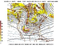
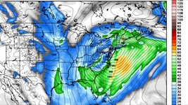
The flow has split into 3 different jet streams, the Arctic, Polar and Subtropical. In this current model depiction, there is energy along each jet, running in sync with each other. With this Teleconnection signal, if 2 of these were to phase together, we have ourselves a storm ripping up the east Coast. If a Triple Phaser occurs (Unlikely) this storm could be biblical. Right now, the Models are all over the place, some stay no storm, some say phase, some say Triple Phase Superbomb.
To recap, we have the storm track and the energy. Now lets take a look at the models.
Third: Model Discussion (Written By a Professional Meteorologist
CDC/CPC agreed upon PNA spike soaring over +3SD, temporally collocated with an NAO fall from that's > 2 SD right across the ides of the month. Meanwhile, the MJO is even stronger in phase 8 from now through the 15th leading up to that date... (see below)
It really is a pretty fantastic teleconnector convergence and almost a hemispheric syncing toward unleashing something large. How large and what, still to be determined.
We'll see how it flops out of the erroneous runs that will be rife for the time being.
NAVGEM ... last 3 cycles are nailing impressive stream interaction and signaling possible massive bomb -- rather than roll-eyes and make fun, folks who know better would raise an eye-brow when a model with a specific progression bias overcomes it's native short-coming to express a solution that goes against, but one that fits into fore said teleconnector arguments.
The Euro solution should be taken seriously... The 12z GFS while not on board migrated substantially into this amplitude with better expressed western ridge and digging jet into the Lakes region during the same time...
Fourth: Blocking
A Greenland block is a staple of a major snowstorm. That NAO turns negative at jut the right time, allowing for a weak block to be in place. Albeit weak, this block helps force the system up the coast, instead of being flung out to sea. Watch out for a Cutter though, that is also in the realm of possibility.
...........
So to point out the elephant in the room, there is a whopper of a signal for March 13th. (caution, its a signal, not a reality) Every key ingredient is in place, now can the atmosphere bake a cake? We'll find out over the coming week.
Should be fun!
First: NAO/PNA Teleconnection
When the NAO goes Negative, and the PNA goes positive, a storm track normally sets up along the Eastern Seaboard. This doesn't mean a storm WILL happen, but if one was to form, it would be coastal. Here's the Teleconnection indices for the coming weeks.

It is obvious that the PNA goes WAY positive, and the NAO trickles down to negative. This means= East Coast storm track
Second: The Ingredients
So we have the track, now where are the ingredients? Right here:

The flow has split into 3 different jet streams, the Arctic, Polar and Subtropical. In this current model depiction, there is energy along each jet, running in sync with each other. With this Teleconnection signal, if 2 of these were to phase together, we have ourselves a storm ripping up the east Coast. If a Triple Phaser occurs (Unlikely) this storm could be biblical. Right now, the Models are all over the place, some stay no storm, some say phase, some say Triple Phase Superbomb.
To recap, we have the storm track and the energy. Now lets take a look at the models.
Third: Model Discussion (Written By a Professional Meteorologist
CDC/CPC agreed upon PNA spike soaring over +3SD, temporally collocated with an NAO fall from that's > 2 SD right across the ides of the month. Meanwhile, the MJO is even stronger in phase 8 from now through the 15th leading up to that date... (see below)
It really is a pretty fantastic teleconnector convergence and almost a hemispheric syncing toward unleashing something large. How large and what, still to be determined.
We'll see how it flops out of the erroneous runs that will be rife for the time being.
NAVGEM ... last 3 cycles are nailing impressive stream interaction and signaling possible massive bomb -- rather than roll-eyes and make fun, folks who know better would raise an eye-brow when a model with a specific progression bias overcomes it's native short-coming to express a solution that goes against, but one that fits into fore said teleconnector arguments.
The Euro solution should be taken seriously... The 12z GFS while not on board migrated substantially into this amplitude with better expressed western ridge and digging jet into the Lakes region during the same time...
Fourth: Blocking
A Greenland block is a staple of a major snowstorm. That NAO turns negative at jut the right time, allowing for a weak block to be in place. Albeit weak, this block helps force the system up the coast, instead of being flung out to sea. Watch out for a Cutter though, that is also in the realm of possibility.
...........
So to point out the elephant in the room, there is a whopper of a signal for March 13th. (caution, its a signal, not a reality) Every key ingredient is in place, now can the atmosphere bake a cake? We'll find out over the coming week.
Should be fun!
Last edited:

