-
Welcome to AlpineZone, the largest online community of skiers and snowboarders in the Northeast!
You may have to REGISTER before you can post. Registering is FREE, gets rid of the majority of advertisements, and lets you participate in giveaways and other AlpineZone events!
You are using an out of date browser. It may not display this or other websites correctly.
You should upgrade or use an alternative browser.
You should upgrade or use an alternative browser.
Average Annual Snowfall in the Northeast (Map)
- Thread starter Nick
- Start date
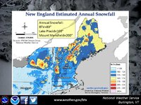
Cool map from the US Weather Service in Burlington

That is quite neat to see. The White Mountains of New Hampshire are the clear winner.
I didn't realize how much better southern Vermont fared than southern NH. I would have assumed they would be somewhat similar.
St. Bear
New member
I wonder what the data set they're using for this is? I know the past couple years, So. VT has been the bullseye of a number of storms, that may swing the averages a little bit.
I didn't realize how much better southern Vermont fared than southern NH. I would have assumed they would be somewhat similar.
Lot more elevation in Southern VT mountains. Heck the Berkshires have higher elevation than most of southern nh
Yeah that totally makes sense, I guess I never really thought of it before or visualized it like this map.
someone should superimpose a ski resort map with this.
St. Bear
New member
Also interesting that the So. Greens have a much broader coverage of snow, where No. VT looks like it's just the peaks. I assume that's because the So. Greens are broader mountains that cover more area, and the No. Greens are steeper?
from_the_NEK
Active member
Also interesting that the So. Greens have a much broader coverage of snow, where No. VT looks like it's just the peaks. I assume that's because the So. Greens are broader mountains that cover more area, and the No. Greens are steeper?
That is exactly correct.
However, snow retention is not as good in the southern greens (warmer average temps).
KevinF
Member
So according to this map, the eastern half of Massachusetts -- i.e., Worcester and Middlesex counties -- average 100 to 124 inches of snow a year?
Some Googling shows that Worcester airport usually sees in the 60-70 inch / year range. NWS is saying nearly twice that?
Some Googling shows that Worcester airport usually sees in the 60-70 inch / year range. NWS is saying nearly twice that?
Puck it
Well-known member
Where's the Jay Cloud?
BenedictGomez
Well-known member
I wonder what the data set they're using for this is?
Right. I mean, is this 2000 to 2014 or is it 1937 to 2014 etc.... More date = more meaningful, but it doesn't say.
fbrissette
Well-known member
These are Prism maps. They are produced by interpolating weather stations (mostly in the valleys) using an elevation and slope aspect dependent algorithm. Prism maps are beautiful but are essentially elevation dependent.
There is no weather, satellite or climate knowledge in these maps.
They are useful for a lots of applications, but NOT to figure out who gets the most snow.
There is no weather, satellite or climate knowledge in these maps.
They are useful for a lots of applications, but NOT to figure out who gets the most snow.
Cornhead
Well-known member
- Joined
- Dec 4, 2010
- Messages
- 2,841
- Points
- 48
Big red spot above Snow Ridge, my semi local powder hot spot. LE is usually nice and fluffy too. Can't wait for my first visit, usually about the time I've had enough of man made groomers at my home hill, Greek Peak. I had more days at Snow Ridge than I did at Greek the first month or so of last season, and I have a season's pass at Greek.
Sent from my DROID X2 using Tapatalk 2
Sent from my DROID X2 using Tapatalk 2
slatham
Well-known member
Elevation explains both low snow in Southern NH vs So VT and high snow in the Whites. While the highest totals are in the Whites, that is irrelevant to someone choosing lift served skiing, which tops out at 4,100', whereas there are many, many peaks higher than that.
While I don't have the data in front of me, I believe that VT ski areas have higher ave annual snowfall than NH areas.
While I don't have the data in front of me, I believe that VT ski areas have higher ave annual snowfall than NH areas.
from_the_NEK
Active member
Elevation explains both low snow in Southern NH vs So VT and high snow in the Whites. While the highest totals are in the Whites, that is irrelevant to someone choosing lift served skiing, which tops out at 4,100', whereas there are many, many peaks higher than that.
While I don't have the data in front of me, I believe that VT ski areas have higher ave annual snowfall than NH areas.
4100 is nearly treeline. Above that the snow is often so wind blown, measuring it is nearly pointless. FYI - Mt Washington avg = 281. http://www.mountwashington.org/weather/normals.php
ss20
Well-known member
SoVt also has an underrated elevation advantage. Stratton's peak is over 4,000 feet.
Calling BS on anywhere in CT averaging over 100 inches.
Calling BS on anywhere in CT averaging over 100 inches.
benski
Active member
SoVt also has an underrated elevation advantage. Stratton's peak is over 4,000 feet.
Calling BS on anywhere in CT averaging over 100 inches.
Stratton tops out at 3875 and get 180 inches a year.
Sent from my iPhone using AlpineZone
xwhaler
Active member
Mahoosuc and Bigelow Range in Western Maine FTW
Similar threads
- Replies
- 953
- Views
- 142K
- Replies
- 43
- Views
- 15K
- Replies
- 9
- Views
- 4K