-
Welcome to AlpineZone, the largest online community of skiers and snowboarders in the Northeast!
You may have to REGISTER before you can post. Registering is FREE, gets rid of the majority of advertisements, and lets you participate in giveaways and other AlpineZone events!
You are using an out of date browser. It may not display this or other websites correctly.
You should upgrade or use an alternative browser.
You should upgrade or use an alternative browser.
First Snowfalls, Upcoming weather and Storms of winter 2022-2023. Storm snow totals, Observations and Predictions?
- Thread starter MidnightJester
- Start date
Scottyskis2
Active member
- Joined
- Dec 17, 2022
- Messages
- 433
- Points
- 28
From Rebecca Facebook page
"
I had a few things that took my attention, so I couldn't post anything until now....
This will be a quick post...
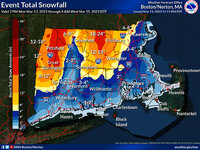
Here is a look at the current surface chart and P-type radar. There are no real changes to what I’ve been saying for snow amounts and impacts. As the primary transfers to the coast the snow shield will move Northwest to Southeast. This is a fast-moving storm so that will help limit accumulations. Here is a general snowfall map I’ve made up. It's possible that local amounts of up to 10-12 inches could occur over Northwestern into Central Pennsylvania. Cold surfaces will see more snow than warm surfaces. We will have lake effect snow showers during the overnight into Saturday early morning, these could add an additional 1-3 inches of snow.
Most of the weekend will be dry
Then for Monday into Wednesday we will be dealing with bigger storm.
We will see primary low-pressure transfer to the Middle Atlantic Coast. This will track North and East passing South of Long Island and a little south and east of Cape Cod. The storm looks to bomb out (rapidly strengthen) and become a major nor’easter. Bringing snow, rain and strong winds to the region. The track will be close enough for the coastal plain, Philly, Maryland and Delaware to see mix and rain. The storm will pull in cold air, changing any rain/mix in the interior Northeast to heavy snow. Parts of Northeast Pennsylvania Eastern New York State and Western into Northern New England Have the potential 8 12 inches with amounts of up to two feet possible. Snow showers will hang around into Wednesday. For later Monday into Tuesday, winds along the coast will be 50-60 mph, winds will remain very gusty into Wednesday. Moderate to major coastal flooding will be possible.
There is still some question as to the exact track. Over the weekend, I will try to narrow down snow amounts and impacts."
Kingslug20
Well-known member
- Joined
- Oct 14, 2021
- Messages
- 2,506
- Points
- 113
Kingslug20
Well-known member
- Joined
- Oct 14, 2021
- Messages
- 2,506
- Points
- 113
Scottyskis2
Active member
- Joined
- Dec 17, 2022
- Messages
- 433
- Points
- 28
More snow storm s coming
From Hudson Valley NY Facebook page:
"Saturday Morning Thoughts on Nor'easter Potential
 Content Difficulty Level: Moderate/High
(
 a deep dive nerdy technical analysis)
 Timing- Monday AM- Tue PM
A snowy and slushy morning across the Hudson Valley, and we'll have some analysis on the exiting storm this afternoon. But let's talk about the Monday/Tuesday storm potential. These maps all showcase surface pressure forecast with this system. These images are generally all showing Tuesday around mid day. The first two images are the "ensemble mean" position for the storm. An ensemble runs the scenario with minor variations, multiple times... (30 different times on the GFS, and 50 times on the European). The images shown represent the blend of all those scenarios. They're useful because in a setup like this one, we're seeing the operational runs of the models shift east and west every few hours. The ensembles give us a better idea of the average, which is helpful in picking up any trends in the overall data. It's also helpful for seeing if the various ensemble scenarios are similar with each other, or if they're spread far apart. In this time frame, with this type of system, the ensembles are an excellent tool for projecting where this storm will track. You can see the European ensemble mean (average) is a bit further east than the GFS. That's largely because the European has a few outlier solutions that are well east of the mean.
The 3rd and 4th images are the "deterministic" or "operational" runs of the European and GFS models. These are the solutions from the individual run of the model. Notice the pressure is lower than the mean, that's because the individual solution shows only 1 scenario of the storm, while the ensemble mean blends the pressures of the various solutions together. The deterministic runs are also further inland than the ensemble mean, an indicator that the well out to sea solutions are unlikely.
The last image shows the spread of the ensemble low pressures on the European (50 different low positions). You can see how wide the distribution is. This represents that there is still considerable uncertainty with how this storm will track. This gives us low confidence on the exact impact here in the Hudson Valley, because depending on the track of the Low, the resulting impact in the Hudson Valley changes dramatically....
- Yellow Circle: If the low tracks in the Yellow circle, the heavy snow and wind would be east of the Hudson Valley. A strong nor'easter would batter the New England coast, with 12"+ likely from Maine to Rhode Island. The Hudson Valley would see a couple of inches of snow, possibly 6" closer to the NY/CT border.
- Blue Circle: Hudson Valley would be in the battle zone. Worst conditions would be east of the Hudson River, where 12" or more could fall. West of the Hudson would still see a formidable storm, with 6 to 12 inches possible. But the worst impacts likely would be just east of the NY/CT and NY/MA border.
- Red Circle: A Major Nor'easter for the Hudson Valley. Snow rates over 2" per hour at times, blowing and drifting snow, extremely hazardous travel. Snow accumulation region wide could exceed 1 foot, with some areas possibly approaching 2 feet of snow.
Right now, the ensembles are on the edge of the Blue and Red circles. The deterministic runs of the GFS and European are both in the Red circle. So we are certainly tracking what could be a major nor'easter for the Hudson Valley. We'll monitor the trends, and keep you updated on what becomes more likely. Buckle up for a wild ride over the next few days!
-Bill
From Hudson Valley NY Facebook page:
"Saturday Morning Thoughts on Nor'easter Potential
(
A snowy and slushy morning across the Hudson Valley, and we'll have some analysis on the exiting storm this afternoon. But let's talk about the Monday/Tuesday storm potential. These maps all showcase surface pressure forecast with this system. These images are generally all showing Tuesday around mid day. The first two images are the "ensemble mean" position for the storm. An ensemble runs the scenario with minor variations, multiple times... (30 different times on the GFS, and 50 times on the European). The images shown represent the blend of all those scenarios. They're useful because in a setup like this one, we're seeing the operational runs of the models shift east and west every few hours. The ensembles give us a better idea of the average, which is helpful in picking up any trends in the overall data. It's also helpful for seeing if the various ensemble scenarios are similar with each other, or if they're spread far apart. In this time frame, with this type of system, the ensembles are an excellent tool for projecting where this storm will track. You can see the European ensemble mean (average) is a bit further east than the GFS. That's largely because the European has a few outlier solutions that are well east of the mean.
The 3rd and 4th images are the "deterministic" or "operational" runs of the European and GFS models. These are the solutions from the individual run of the model. Notice the pressure is lower than the mean, that's because the individual solution shows only 1 scenario of the storm, while the ensemble mean blends the pressures of the various solutions together. The deterministic runs are also further inland than the ensemble mean, an indicator that the well out to sea solutions are unlikely.
The last image shows the spread of the ensemble low pressures on the European (50 different low positions). You can see how wide the distribution is. This represents that there is still considerable uncertainty with how this storm will track. This gives us low confidence on the exact impact here in the Hudson Valley, because depending on the track of the Low, the resulting impact in the Hudson Valley changes dramatically....
- Yellow Circle: If the low tracks in the Yellow circle, the heavy snow and wind would be east of the Hudson Valley. A strong nor'easter would batter the New England coast, with 12"+ likely from Maine to Rhode Island. The Hudson Valley would see a couple of inches of snow, possibly 6" closer to the NY/CT border.
- Blue Circle: Hudson Valley would be in the battle zone. Worst conditions would be east of the Hudson River, where 12" or more could fall. West of the Hudson would still see a formidable storm, with 6 to 12 inches possible. But the worst impacts likely would be just east of the NY/CT and NY/MA border.
- Red Circle: A Major Nor'easter for the Hudson Valley. Snow rates over 2" per hour at times, blowing and drifting snow, extremely hazardous travel. Snow accumulation region wide could exceed 1 foot, with some areas possibly approaching 2 feet of snow.
Right now, the ensembles are on the edge of the Blue and Red circles. The deterministic runs of the GFS and European are both in the Red circle. So we are certainly tracking what could be a major nor'easter for the Hudson Valley. We'll monitor the trends, and keep you updated on what becomes more likely. Buckle up for a wild ride over the next few days!
-Bill
MidnightJester
Well-known member
- Joined
- Oct 7, 2011
- Messages
- 1,075
- Points
- 83
We have a growing Snow storm on our hands with snow around for all but the heavy snow is still in lower NY and Lower Vermont.


Kingslug20
Well-known member
- Joined
- Oct 14, 2021
- Messages
- 2,506
- Points
- 113
From france...Why are you leaving- you have a flight home?
Kingslug20
Well-known member
- Joined
- Oct 14, 2021
- Messages
- 2,506
- Points
- 113
Skiing in 60mph blizzards..got old fastWhy are you leaving- you have a flight home?
Scottyskis2
Active member
- Joined
- Dec 17, 2022
- Messages
- 433
- Points
- 28
From Rebecca Facebook page
Looking like 93 winter late March snow for the Northeast I remember coming back from FL and the most snow ever fell where we lived in Centereach Island of long:
"
Sunday night, the primary will be approaching, then we will see energy transfer from the primary will transfer to the coast, Sunday night into the overnight, we will see light snow breakout across western parts of the region, these snow showers will work their way east into Monday. Then we will see the secondary develop off the Carolina Coast. The storm is going to come up the Coast, and intensify as it does so. The trough is going to capture the coastal low, meaning it will force the low to slow and maybe even briefly stall south and east of Cape Cod, where it should end up bombing out. From here the storm will do a loop before heading into the Gulf of Maine on Wednesday.
The bulk of the storm will be Monday evening through Tuesday.
By Monday evening snow rates will be picking up over Northeast Pennsylvania, Northern New Jersey, Central and Southeast New York State and Southern into Central New England. We will see cold air wrapping into the storm from the Northeast this will increase snowfall rates over New England. At the same time, we will have an inverted trough (points northward instead of southward) sitting over New York State into Southern New England, this will help to extend that snow shield south and east. The question is how far south and east will that snow shield be. The Mid into the upper levels will be supportive for a lot of lift, so this will enhance snowfall rates, where the banding ends setting up snowfall rates of 2-4 inches per hour will be possible.
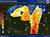
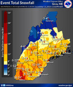
This is going to be a long duration event with snow lasting through Wednesday, it will also be an elevation-dependent storm, this is going to bring a widespread 6 to 20 inches of accumulation from Northern into Central and the Eastern half of New York State, down into Northeast Pennsylvania, Northwest New Jersey and northwest Connecticut, Western and Central Massachusetts, Vermont, New Hampshire and into Southwest Maine. The highest amounts will be in the in the Catskills, Berkshires, Helderbergs, Adirondacks, Greens, Whites, into the Monadnocks These areas will likely see 12-30 inches of snow. The Poconos look to see 6-12 inches of snow while the rest of Northeast Pennsylvania picks up 3-8 inches, with areas around Allentown and out across Central into Northwest Pennsylvania seeing 1-3 inches.
South of these areas temperatures will be marginal so there will be a mix; the further south you go the more mix you will see.
Much of Connecticut and northern and Central Rhode Island to areas north and west of New York City, down into Central and Northern New Jersey look to see 3-6 inches. With New York City and Eastern Massachusetts including Boston seeing 1-3 inches, Northern Maine looks to see 1-3 inches with Central and Southern Maine seeing 3-8 inches. The Cape, and Coastal Connecticut down across most of Long Island and southern New Jersey down to near Toms River and places like Philadelphia a C-1 inch. Southwest including Pittsburgh and Southern Pennsylvania Maryland and Delaware and the Jersey Shore this will be a rain event.
Along the Coastal Plain winds will be storm with winds of 40-60 mph with gust of 75 to 80 mph possible, this will be especially for the Cape and Offshore Islands. Inland winds of 20 – 30 mph with gust up around 50 mph will be possible. Winds will create blizzard like conditions for a large part of the region, There could be a blizzard declared for part of New England.
Widespread and regional power outages are possible across most of New England. The risk for power outages will extend into Eastern New York State and Northwest Pennsylvania and northern New Jersey.
Heavy coastal flooding and beach erosion and rough surf will accompany the storm.
Any changes in the track west or east will impact snow totals. As is always the case in these types of storms dry slots will impact parts of the region, where those dry slots setup has yet to be determined.
Kingslug20
Well-known member
- Joined
- Oct 14, 2021
- Messages
- 2,506
- Points
- 113
Kingslug20
Well-known member
- Joined
- Oct 14, 2021
- Messages
- 2,506
- Points
- 113
Well..I sure as hell brought it to France....too fucking much...
This will be more manageable
This will be more manageable
skef
Active member
Here’s a new (to me) thing: NYT gives probability distributions for storm totals. For example:
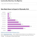
Gift link for the current storm: https://www.nytimes.com/2023/03/12/...ytcore-ios-share&referringSource=articleShare

Gift link for the current storm: https://www.nytimes.com/2023/03/12/...ytcore-ios-share&referringSource=articleShare
Edd
Well-known member
I’d committed to going up north to ski for today and tomorrow but I’ve got to be at work Wednesday and didn’t feel like doing the potential shitty drive home Tuesday afternoon, which is not like me. Going to hopefully get some new bindings on my old pow skis today and use them at Gunstock tomorrow.
Kingslug20
Well-known member
- Joined
- Oct 14, 2021
- Messages
- 2,506
- Points
- 113
Just love these weather prediction things.....
thebigo
Well-known member
Good info on local NWS winter pages now, different output from NYT but may be more up to date: https://www.weather.gov/gyx/winter
Tomorrow is town meeting day in NH, many schools are closed, may be a larger turn out than normal midweek storm. I am taking a few ragged kids to loon, should be fun.
Tomorrow is town meeting day in NH, many schools are closed, may be a larger turn out than normal midweek storm. I am taking a few ragged kids to loon, should be fun.
I thought for a quick second I might head to mt snow area for a couple nights but goddamn are cheap rooms in VT impossible to come by so im heading to the MWV instead. It won't take all that much to be awesome. fingers crossed on the wind
MidnightJester
Well-known member
- Joined
- Oct 7, 2011
- Messages
- 1,075
- Points
- 83
Thank you to Ullr and Winter for staying around for us snow lovers. The North East is about to be DUMPED on by this Snow storm. Good luck to anyone that drives through this storm Tuesday and Wednesday.

Best Snow hunting to all : )~
It is currently looking like next ST. Paddy's day weekend after this storm is trending a little warm with moisture and could be problematic. Here's hoping that changes.

Best Snow hunting to all : )~
It is currently looking like next ST. Paddy's day weekend after this storm is trending a little warm with moisture and could be problematic. Here's hoping that changes.
Last edited:
urungus
Well-known member
Similar threads
- Replies
- 953
- Views
- 146K

