• Welcome to AlpineZone, the largest online community of skiers and snowboarders in the Northeast!

    You may have to REGISTER before you can post. Registering is FREE, gets rid of the majority of advertisements, and lets you participate in giveaways and other AlpineZone events!

First Snowfalls, Upcoming weather and Storms of winter 2022-2023. Storm snow totals, Observations and Predictions?

MidnightJester

Well-known member
Joined
Oct 7, 2011
Messages
1,005
Points
83
If you aren’t going there why do you torture yourself looking?
Because it is better then the current look of the North East mountains and mostly because I look at it as a US total snow globe that is just getting going and will be here eventually : ( One of his reports will eventually flow into the North East or maybe a Good Blizzard will come to us that will make us smile like that storm could if it was here.
 

MidnightJester

Well-known member
Joined
Oct 7, 2011
Messages
1,005
Points
83
Here comes the seasons first good snow and the first of hopefully many inches of snow to fall on Vermont, New York and the North East this season.
Screenshot_20221113-125702_AccuWeather.jpg
Screenshot_20221113-125635_AccuWeather.jpg
 
Last edited:

MidnightJester

Well-known member
Joined
Oct 7, 2011
Messages
1,005
Points
83
The NorthEast and Vermont finally getting a mention and making it onto the tail end of the Mountain snow weather forecast radar.
 

MidnightJester

Well-known member
Joined
Oct 7, 2011
Messages
1,005
Points
83
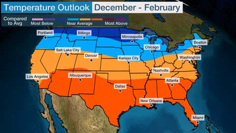
This will be nice if this updated normal to a cooler trend settles in for the North. Maybe the storms that come our way will stay mostly snow this season instead of shifting to "Unhappy snow"
wsi_dec-feb_1117.jpg
 
Last edited:

MidnightJester

Well-known member
Joined
Oct 7, 2011
Messages
1,005
Points
83
The new weather front coming through this Thanksgiving weekend to the North East is looking to be a little too warm at town levels throughout most of VT. Here's hoping the Mountain elevation above town and the more northerly mountains grab more snow then rain.
 
Last edited:

MidnightJester

Well-known member
Joined
Oct 7, 2011
Messages
1,005
Points
83
Possible Back to Back storm systems will be rolling across the country starting next week. There will be mixed precipitation in the first system for the North East this upcoming week around Wednesday/Thursday with midweek rain and/or freezing sleet and a possible multi day snowmaking system starting Sunday the 11th of December.
 

MidnightJester

Well-known member
Joined
Oct 7, 2011
Messages
1,005
Points
83
Last edited:

MidnightJester

Well-known member
Joined
Oct 7, 2011
Messages
1,005
Points
83
Incoming storm is getting closer to kickoff time. What, Where and when we will see :)
DCT_SPECIAL48_1280x720.jpg


Best Snow-Hunting to all : )~
 

2Planker

Well-known member
Joined
May 16, 2007
Messages
1,650
Points
113
Location
MWV, NH
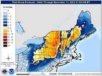
MWV is right in that sweet spot, 18"-24"
Love being on the Eastern side of a mt range
 

KustyTheKlown

Well-known member
Joined
Mar 1, 2013
Messages
5,780
Points
113
Location
Brooklyn
lol the colors on that map give me a probably unhealthy amount of confidence about going to rutland tomorrow evening via 87 to Whitehall.
 

MidnightJester

Well-known member
Joined
Oct 7, 2011
Messages
1,005
Points
83
First Nor'easter Storm totals from South to North Vermont. Best Snowhunting to all : )~

Mount Snow 24"+
Stratton 24"
Okemo 27"
Killington 22"
Sugarbush 22" +
Mad River Glen 23"
Bolton Valley 14"
Stowe 10" +
Smugglers Notch 14"
Jaypeak 12"+
 
Last edited:

2Planker

Well-known member
Joined
May 16, 2007
Messages
1,650
Points
113
Location
MWV, NH
First Nor'easter Storm totals from South to North Vermont. Best Snowhunting to all : )~

Mount Snow 24"+
Stratton 24"
Okemo 27"
Killington 22"
Sugarbush 22" +
Mad River Glen 23"
Bolton Valley 14"
Stowe 10" +
Smugglers Notch 14"
Jaypeak 12"+
Wildcat will be close to 30” maybe more…
24” was at 9am and it continued all day.
27” on the deck in Conway at 1,000’
 

MidnightJester

Well-known member
Joined
Oct 7, 2011
Messages
1,005
Points
83
Incoming pre-Christmas storm not looking too good for the North East as a whole this weekend. If it comes in as it is looking Its going to lock in a frozen base if the 1/2 to inch of rain comes in followed by the teens at night with single digit and "minus" Windchill's possible for days. Going to take the next decent storm to make the trails and woods fun and "safer again" because ice and trails are not much fun and woods and ice are zero fun. Grab whatever trails and woods you can till then : )

Lets go snowmakers : )~

After this storm Its looking like the next decent storm with snowmaking till then will allow most mountains to get most Lift areas and trails open by new years it seems now.
 
Last edited:

KustyTheKlown

Well-known member
Joined
Mar 1, 2013
Messages
5,780
Points
113
Location
Brooklyn
dot gov is holding on to a snowy solution for sugarloaf, which is where i will be from 12/27-31. i know this is almost certainly not going to verify, but I'm hanging my hope on it for now... at least i will be in the thick of family xmas while the wet comes in, and then hopefully some resurfacing before i arrive on 27th, and then some snow chances 28-30th.


1671469529960.png
 
Top