• Welcome to AlpineZone, the largest online community of skiers and snowboarders in the Northeast!

    You may have to REGISTER before you can post. Registering is FREE, gets rid of the majority of advertisements, and lets you participate in giveaways and other AlpineZone events!

First Snowfalls, Upcoming weather and Storms of winter 2023-2024. Storm snow totals, Observations and Predictions?

Ski2LiveLive2Ski

Active member
Joined
Mar 20, 2013
Messages
670
Points
43
Basically seeing what terrain survives this week to make it to the snow forecast for Sunday and how well that can rescue the season. Glad I have a Beaver Creek trip in 3 weeks to look forward to. Expect it was a good call moving that from Xmas to Spring Break as it is unlikely Northeast skiing will be as good in 3 weeks as it was over Xmas, and BCreek skiing should be better now than it was in Dec.
 

Hillwalker95

Member
Joined
Jan 20, 2020
Messages
56
Points
8
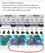
For Sat night/Sun, I am seeing conflicting things - SnowForecast shows 6 inches at Waterville Valley. Other sites show rain in similar areas. Any thoughts or is it basically on the borderline?
 

drjeff

Well-known member
Joined
Jan 18, 2006
Messages
19,396
Points
113
Location
Brooklyn, CT
For Sat night/Sun, I am seeing conflicting things - SnowForecast shows 6 inches at Waterville Valley. Other sites show rain in similar areas. Any thoughts or is it basically on the borderline?
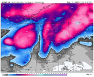
Definitely going to be some moisture (maybe even a decent amount around), Will be colder air to the North, warmer air to the South, how far South the Cold air can get and hold still TBD... Right now it seems like if you drew a line between Albany, NY and Portland, ME, that South of there, short of maybe a few higher elevation places, will likely be all liquid. Probabaly 50 miles North of there will be all snow (short of maybe some low river valley locations) and it's in the 50 mile wide zone is likely where the rain/snow battle plays out. Some models want to attach a bunch of moisture to this storm, so if that plays out and there is enough cold air around some places could end up with a very nice snow fall total total.

Obviolsuy as it gets closer to when this storm will arrive, more of the variables will be able to be figured out. Right now it just seems like there's a very strng chance that there will be a storm system rolling through the region late weekend
 

Zand

Well-known member
Joined
Dec 30, 2003
Messages
4,348
Points
113
Location
Spencer, MA
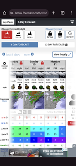
Screenshot_20240306-134810.png
Snow-forecast.com outlook for Jay is a sight for sore eyes. I'm sure it won't pan out, but my plan is to head there Sun-Tue. If the forecast totally flops then I'll reconsider but I feel like either way Jay is the best chance to do some respectable skiing.
 

parahelia

Active member
Joined
Jul 24, 2018
Messages
123
Points
43
For Sat night/Sun, I am seeing conflicting things - SnowForecast shows 6 inches at Waterville Valley. Other sites show rain in similar areas. Any thoughts or is it basically on the borderline?

The key models don't agree... the GFS is a lot warmer than the ECMWF at this point. Both models point to lots of moisture but differences on type. Should start to converge within a day or two. Different weather apps favor different models so you get widely varying forecasts depending on what you use.
 

slatham

Well-known member
Joined
Sep 17, 2012
Messages
2,541
Points
113
Location
LI/Bromley
Lots of potential but higher than normal uncertainty especially given lack of cold air in place. The storms dynamics, elevation and storm track all beyond critical. As noted above the GFS is warmer than Euro, but the GFS ensemble is colder and more in line with Euro. Caution given how poor the models have been, but this should be watched. Would like to avoid an early March melt and end….
 

slatham

Well-known member
Joined
Sep 17, 2012
Messages
2,541
Points
113
Location
LI/Bromley
Driving through Vermont right now and it’s a very strange “second” stick season.
 

tumbler

Well-known member
Joined
Jan 10, 2014
Messages
1,507
Points
83
This is typical for March. Snow at the summit at nothing at the base is typical.
 

MidnightJester

Well-known member
Joined
Oct 7, 2011
Messages
988
Points
63
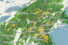
Such wrong colored moisture blobs it's sad. Didn't see a single NE mountain report that said anything good except preserving snow.

Odd that most static weather forecasts maps from the US don't seem to extend the forcast blobs into Canada. The in-motion ones do but not the map forcast images. Is there some odd international weather rules?
 

Zand

Well-known member
Joined
Dec 30, 2003
Messages
4,348
Points
113
Location
Spencer, MA
This may actually really work out well. 4-8" of heavy wet basebuilding snow on Saturday night, a lull on Sunday to drive up in, then another 6-12" of drier colder snow Sunday night into Monday.
 
Top