• Welcome to AlpineZone, the largest online community of skiers and snowboarders in the Northeast!

    You may have to REGISTER before you can post. Registering is FREE, gets rid of the majority of advertisements, and lets you participate in giveaways and other AlpineZone events!

New storm on the way

drjeff

Well-known member
Joined
Jan 18, 2006
Messages
19,400
Points
113
Location
Brooklyn, CT
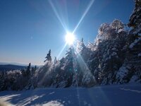
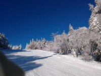
Spectacular out on the hill at Mount Snow this morning. Cold, but not windy. Tons of machine groomed packed powder. Crowds finally starting to build about 10:15 - rode the Bluebird with my wife 8 times between 7:30 and 9:45 - going to see if we can make it to noon until the crowds likely winIMG_20200215_082635575.jpgIMG_20200215_082627250_MP.jpgIMG_20200215_081025909.jpgIMG_20200215_073853749.jpg
Sent from my Moto Z (2) using AlpineZone mobile app
 

Smellytele

Well-known member
Joined
Jan 30, 2006
Messages
10,222
Points
113
Location
Right where I want to be
No lines at Cannon today. No wind and bluebird.-8 to start but with no wind nice! Driving up hit a low of -13. Scared people off


Sent from my iPhone using AlpineZone
 

Edd

Well-known member
Joined
Nov 8, 2006
Messages
6,678
Points
113
Location
Newmarket, NH
Spectacular out on the hill at Mount Snow this morning. Cold, but not windy. Tons of machine groomed packed powder. Crowds finally starting to build about 10:15 - rode the Bluebird with my wife 8 times between 7:30 and 9:45 - going to see if we can make it to noon until the crowds likely winView attachment 26277View attachment 26278View attachment 26279View attachment 26280

Sent from my Moto Z (2) using AlpineZone mobile app
Sweet pics.


Sent from my iPhone using AlpineZone
 

So Inclined

Active member
Joined
Sep 10, 2017
Messages
240
Points
28
I would ditch the insanely crowded weekend at hunter and spend that money on a much less crowded Friday at K.

I would've too - but this is a "working at Hunter Saturday and Sunday" type situation.:D
It was still pretty good today, crowds and all.
 

abc

Well-known member
Joined
Mar 2, 2008
Messages
5,935
Points
113
Location
Lower Hudson Valley
I was at Bretton Woods cross country skiing. I waited till noon when the temperature risen to double digit! :) I expected crowds at parking lot and on trails. Not at all.

Trail was almost deserted, feels more like a midweek day than a holiday Saturday.

No wind, not cold at all. Sat outside on my “mini-break”. Though on the downhill return leg, my fingers started to hurt (as they didn’t get to do any work).
 

slatham

Well-known member
Joined
Sep 17, 2012
Messages
2,549
Points
113
Location
LI/Bromley
My middle daughter skied Bromley today and was surprised how good it was and how mellow the crowds were. Likely due to cold forecast and lack of understanding of the powers of the Bromley sun.

I got out for two runs before closing and do not remember ever seeing so much ice on the trees. Sections of the upper mountain panorama were noticeably lower due to ice compressing the trees. Beautiful sight though. Can’t wait until tomorrow!
 

ScottySkis

Well-known member
Joined
Jan 16, 2011
Messages
12,294
Points
48
Location
Middletown NY
Good day today...nothing got skied off...monster moguls on the front 4...[/QUO

Happy to hear

Good finally might be coming for everyone on ski forum s
Well today is surely warmer, than Friday and yesterday.

This evening into tonight we will see a weak disturbance with a cold front move through. This disturbance won’t have a lot of moisture with it. But isolated snow showers to the north and mix/rain showers to the south are possible. Higher elevation areas in our northern areas could end up with some light accumulations, but for everyone else, little to no accumulation is expected.

Presidents’ Day will be a little cooler than today, but temperatures will be close to seasonable.

For Monday night into Wednesday we will see a strong area of low pressure move over the Great Lakes. We will also have high pressure over Atlantic Canada. Temperatures will be marginal, but we could hang on to the cold long enough for some snow to start for parts of Pennsylvania, New York State and New England. Pennsylvania and the southern tier of New York State and Southern New England will quickly change over to a mix/rain, while areas to the north keep the cold longer. As far as snowfall. This won’t be a huge snow maker, New York State (north of the southern tier and Central into Northern New England will see a general 2-4 inches with higher elevations like the Adirondacks, Greens, and Whites seeing a general 3-6 inches with isolated higher amounts possible. Poconos Catskills, and Berkshires around 1-3 inches, with most other areas a dusting to an inch possible. The same areas that have been getting the rain this winter, look to continue that streak with this disturbance.

Behind this disturbance we will see a short lived arctic air mass move back in. So rain, could change back over to some snow on the tail end of the Tuesday into Wednesday disturbances
From Rebecca facecrap

Back to music now
I be on slopes somewhere this Tuesday and Friday.
BellFlat or an Gore
New skis be ready for pick up Wednesday Yes
 

nhskier1969

Active member
Joined
Feb 1, 2016
Messages
436
Points
28
Skied Tenney for the first time today with my Son. What a fun Mtn. Love the tight trail design. Has a Mad River type feel with the trail design. Snow was great. still made turns on untouched groomers at noon.
 

tnt1234

Well-known member
Joined
Sep 12, 2014
Messages
1,511
Points
48
Went to Montage for the first time ever today. Nice day. Good snow. Great bumps on the short steep pitches on the lower section. Nice lodge. Will be back.
 

ScottySkis

Well-known member
Joined
Jan 16, 2011
Messages
12,294
Points
48
Location
Middletown NY
Went to Montage for the first time ever today. Nice day. Good snow. Great bumps on the short steep pitches on the lower section. Nice lodge. Will be back.

Nice

From Rebecca facecrap
I think everyone should be getting too ski fun conditions this week

"Well today is surely warmer, than Friday and yesterday.

This evening into tonight we will see a weak disturbance with a cold front move through. This disturbance won’t have a lot of moisture with it. But isolated snow showers to the north and mix/rain showers to the south are possible. Higher elevation areas in our northern areas could end up with some light accumulations, but for everyone else, little to no accumulation is expected.

Presidents’ Day will be a little cooler than today, but temperatures will be close to seasonable.

For Monday night into Wednesday we will see a strong area of low pressure move over the Great Lakes. We will also have high pressure over Atlantic Canada. Temperatures will be marginal, but we could hang on to the cold long enough for some snow to start for parts of Pennsylvania, New York State and New England. Pennsylvania and the southern tier of New York State and Southern New England will quickly change over to a mix/rain, while areas to the north keep the cold longer. As far as snowfall. This won’t be a huge snow maker, New York State (north of the southern tier and Central into Northern New England will see a general 2-4 inches with higher elevations like the Adirondacks, Greens, and Whites seeing a general 3-6 inches with isolated higher amounts possible. Poconos Catskills, and Berkshires around 1-3 inches, with most other areas a dusting to an inch possible. The same areas that have been getting the rain this winter, look to continue that streak with this disturbance.

Behind this disturbance we will see a short lived arctic air mass move back in. So rain, could change back over to some snow on the tail end of the Tuesday into Wednesday disturbance.
 

ScottySkis

Well-known member
Joined
Jan 16, 2011
Messages
12,294
Points
48
Location
Middletown NY
From Matt facecrap

"TUESDAY STORM UPDATE #4: Nice Refresher, Maybe More, Some Ice & Wind
Although only only N-NY, N-NH and ME are expected to stay 100% snow in this system, on Tuesday you can expect all or most of the day to be snowy in S-V, S-NH, and W-MA as well. There will be some rain and non-snow frozen precip affecting many areas, but there won't be a lot of it, and much of it will happen overnight and after a re-freeze it will largely be of only minor consequence except for some natural terrain. There will however be some wind issues Tuesday as this warm front is a low level jet feeding moisture to the storm passing through Quebec with winds from the south to south east. I will share a map later on tonight with wind hold warnings. Wednesday may well have some isolated wind issues as well, however it's too far out to issue warnings for. It is also likely that there will be an impactful back-end event with both lake effect and orographic lift enhanced snow in the northern areas, possibly convective squalls. That too will be covered later. Attached is the NAM3K simulated radar covering all day Tuesday as well as the most recent NWS snowfall forecast stitch. I'm including the latest ECMWF snowfall map also to help show where it may snow more broadly, but the NWS typically does much better than the models at predicting snow.

Timing: Precip will start off at all tracked resorts outside of CT and RI as snow. By open the snow should have advanced generally to the NY/VT border and by noon impacting most of NH and ME. Precip will remain through the rest of the ski day in most areas, though it may be spotty in W-NY and C-NY sometime in the afternoon.

All Snow Areas: N-NY, N-VT, N-NH and ME resorts should stay all snow in this storm, however some may break freezing briefly in the evening. There should be some fresh snow Wednesday morning on natural terrain in N-VT and ME.

Changeover Areas: W-NY ad C-NY will have changed over to rain/drizzle sometime between open and noon depending on how far east the resort is. S-NY will experience a changeover first to freezing rain probably sometime around noon and eventually rain/drizzle before close. MA experiences a changeover starting around noon as well, but Berkshire East and Wachusett may stay snow until 1-2 p.m. and then freezing rain/drizzle. Generally speaking, S-VT and S-NH will likely experience more new snow than other types of precip. Parts of S-VT and S-NH may change over to freezing rain/drizzle around 2 p.m. and some may escape the changeover until after close. I don't expect a lot of damage as this isn't a super wet system, but it might create some slick spots on natural terrain where the snow is compacted like the troughs of moguls. This will negatively impact conditions most notably in W-NY, C-NY ad S-NY

NWS Snowfall: The ECMWF and NAM3K models are a bit more bullish on the prospects around the SE side of the Presidentials into ME around Mt. Abram and Shawnee Peak. Technically NWS Burlington is also adding in snow on the back-end of this storm for Wednesday, but it is barely measurable as they frequently start low, but I would expect back-end snow to be notable enough in some areas.

"
 

ScottySkis

Well-known member
Joined
Jan 16, 2011
Messages
12,294
Points
48
Location
Middletown NY
From Matt on facecrap

"TUESDAY 2/18 RISK OF MAJOR WIND HOLD
Winds will come primarily from the south to southeast at ground level. Areas of concern in NY will likely see wind holds by 11 a.m. or remain operating for the day. In VT, NH, and ME the threat will grow throughout the day. This is a light to moderate event as these things go.

Bear in mind that a resort confirms the warning here by losing easy access to 25% or more of terrain for 2+ hours due to a wind hold. Keep in mind that there is no lift redundancy at some resorts for certain parts of their terrain, however others have fixed grip chairs that they may run giving potentially even full access but we consider taking two lifts to lap terrain normally accessed with one lift to have lost that easy access. Needing to traverse long distances or uphill also counts as having lost that easy access, but bear in mind that for some who are powder hunters, this is actually a blessing as it helps to keep the goods untouched. Clearly enclosed lifts are generally the most threatened, and then open detachable chairlifts (high speed lifts) are the next most threatened type of lift. Fixed grip lifts do at times go on wind hold, especially lifts that access the summits.

These risks are calculated by wind speed, direction, lift configuration, type of lifts, and perceived resort sensitivity to holds. I do consider the surrounding geography as well, however I am not perfectly familiar with most mountains and their unique weaknesses with wind from every single angle. Generally I do not over-warn on winds.

On Wednesday there may be some issues with wind from the WNW with the primary areas of concern being S-VT, N-NH, and N-ME however it is too early to put out a map for that.
 

ScottySkis

Well-known member
Joined
Jan 16, 2011
Messages
12,294
Points
48
Location
Middletown NY
Scotty, how about you start a thread specifically for weather forecast from various sources?

I did
It in weather thread
Plus I trying too not posting to much here on AZ
I posting more on website fourms where owner is active
And not falling apart
Last week when AZ was down for 12 hours I told them on facecrap alpinezone
Page then it was back up in 15 minutes
Some1 else is going have due that if they want post here or see ski snowboard talk
I mostly going on NY blog
 
Last edited:

bdfreetuna

New member
Joined
Jan 12, 2012
Messages
4,300
Points
0
Location
keep the faith
I did
It in weather thread
Plus I trying too not posting to much here on AZ
I posting more on website fourms where owner is active
And not falling apart
Last week when AZ was down for 12 hours I told them on facecrap alpinezone
Page then it was back up in 15 minutes
Some1 else is going have due that if they want post here or see ski snowboard talk
I mostly going on NY blog

:thumbup: Keep em coming. This is a weather thread!
 
Top