• Welcome to AlpineZone, the largest online community of skiers and snowboarders in the Northeast!

    You may have to REGISTER before you can post. Registering is FREE, gets rid of the majority of advertisements, and lets you participate in giveaways and other AlpineZone events!

Powder alert! Wednesday

Status
Not open for further replies.

bdfreetuna

New member
Joined
Jan 12, 2012
Messages
4,300
Points
0
Location
keep the faith
7" of fresh at Killington / Pico overnight
8" Sugarbush/MRG/Stowe/Smuggs

Cannon, Wildcat pretty much the same. Anywhere in the high peaks. Wednesday 7-8" fresh.

Onthesnow.com
 

Quietman

Member
Joined
Jan 7, 2013
Messages
711
Points
18
Location
SW NH
I like optimists, but let's be realistic!! This is Wednesday's forecast for the summit of Mt. Washington(6,288'), posted by the observatory.

Wednesday:
In the clouds w/ mixed precipitation showers early transitioning to all rain, which may be heavy at times. Snow and sleet accumulations 1-3 inches.

High: Low 30sWind: SW 45-60 mph increasing to 60-80 mph w/ gusts up to 105 mph.Wind Chill: 5 below to 5 above

I think that these guys have a little more insight than onthesnow.com. Just saying......

Feel free to keep posting this nonsense if it makes you feel better about this current lack of snowfall.
 

WWF-VT

Well-known member
Joined
Sep 23, 2005
Messages
2,598
Points
48
Location
MA & Fayston, VT
noaa

the forecast for mount ellen, vermont at 4,083 ft:

last updated at 333 pm est mon feb 01 2016
.tuesday night...partly cloudy until midnight...then becoming
cloudy. A chance of sleet after midnight. Low around 23. Southwest
winds 10 to 25 mph...becoming south and...increasing to 40 to 55 mph
after midnight.
.wednesday...cloudy in the morning...then becoming obscured
in clouds. Rain and freezing rain in the morning...then rain in the
afternoon. High around 45. South winds 60 to 75 mph. Wind chill
values as low as 10 above.
 

Rowsdower

Member
Joined
Dec 16, 2013
Messages
818
Points
18
Location
Upper Bucks/Lehigh Valley, PA
Way too much warm air for that to happen I think. Freezing levels will be way above 6,000ft even, so it won't even perform at elevation. Going to have to wait for the weekend it looks like.
 

mriceyman

New member
Joined
Jan 4, 2012
Messages
1,344
Points
0
Location
cnj
On The Snow has never let me down. Been using it for 3 years faithfully. They know what's up.

Lets make a bet .. Zero accumulating snow on Wednesday vs 6" like on the snow says(which likes snow to drive people to its site). Theyre the last people you should go to for an honest forecast.


Sent from my iPhone using AlpineZone
 

deadheadskier

Moderator
Staff member
Moderator
Joined
Mar 6, 2005
Messages
27,921
Points
113
Location
Southeast NH
I guess you used them for your Dec. 27 prediction of a foot too. Didn't happen.

http://forums.alpinezone.com/showthread.php/137503-Trail-Count-Predictions-for-Tues-Wed

yes, complete swing and a miss

Everyone hopes you're right Tuna, but COME ON. This thread and your weather excitement this week...........pretty lame given what even the non-observer can predict on weather.

Don't get me wrong, I'm a skier, I love the optimism and would want to hug it out with you if your predictions come true. That said, I've got zero faith in your forecasting
 

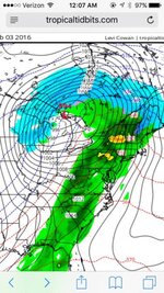
STREETSKIER

Active member
Joined
Feb 16, 2009
Messages
306
Points
28
Location
warren, vt
Sent from my iPhone using Tapatalk
0a73dcb617987b0f9b35ff69a7c15222.jpg
 
Last edited:

SIKSKIER

New member
Joined
Nov 13, 2006
Messages
3,667
Points
0
Location
Bedford and Franconia NH
Matt Noyes at NECN (who I have a lot of faith in) is predicting some snow at the very outset of this storm but whatever might fall will certainly be washed away and then some by the predicted 1 inch rain event.
 
Status
Not open for further replies.
Top