• Welcome to AlpineZone, the largest online community of skiers and snowboarders in the Northeast!

    You may have to REGISTER before you can post. Registering is FREE, gets rid of the majority of advertisements, and lets you participate in giveaways and other AlpineZone events!

Storm Feb 1-2?

dblskifanatic

Active member
Joined
May 24, 2019
Messages
767
Points
43
Snowbird and Alta are at 175..and this hasn't been a good season for them. Its why we picked Stowe..They get a lot. Although this year its been the south getting it. NC had some banner days..Want to see crowds..Check out pics of Beech. Makes ours look empty. Jay betters some CO resorts regularly..
What you don't get at 11000 feet is obviously rain ...thats our killer. Although I was Alta after a rare rain event and it had a crust that was there a long time..I hit it at speed and went flying. Everyone was like WTF is this stuff. Global weirdness.

Having lived in CO for the past five years, we had experienced such consistent snow from December to June year after year. Even in the spring, conditions did not get icy firm yes in the morning but that always changed quickly. While it rains on the front range, it snows along the continental divide and further west. We would drive to Breck (No need for I70) from Colorado Springs where there was no snow to Breck with 4-5 ft snow banks. It was awesome.

Now in Boston, and we have not bothered to ski yet this season which is sad on its own. However, we will be going to Colorado in Early March, again n April and another time in June hopefully A Basin will end normally so CO needs to get it's snow shit together.
 

tnt1234

Well-known member
Joined
Sep 12, 2014
Messages
1,504
Points
48
Reports showing 1 to 3...3 to 5 ...5 to 8...
I predict something will happen at some time. Just not sure what or when.
done
Reinforcing the 2020-2021 mantra - take things one day at a time, and grab what you can when you can.
 

kingslug

Well-known member
Joined
Dec 30, 2005
Messages
7,091
Points
113
Location
Stamford Ct and Stowe
Working so far.
Have to get to CO more. Utah was my go to but thats getting nuts now..which is depressing as I wanted to move there..Epic, Ikon and just plain insane growth has changed that. Have to do some research on CO.
 

dblskifanatic

Active member
Joined
May 24, 2019
Messages
767
Points
43
Working so far.
Have to get to CO more. Utah was my go to but thats getting nuts now..which is depressing as I wanted to move there..Epic, Ikon and just plain insane growth has changed that. Have to do some research on CO.
Living in Colorado Springs provided a different travel route alternative. Getting to Loveland, Keystone or A basin is often better going I70 but going the back way (24 then 9) worked pretty good.

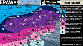
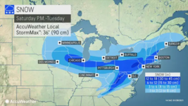
As far as the prediction for next week


SnowfallMapSatToTues28Jan10a.png
 

snoseek

Well-known member
Joined
Jun 7, 2006
Messages
6,361
Points
113
Location
NH
If we could squeeze another 6 in NH that would be nice. The skiing this past two weeks has been super good and the base is slowly stacking nicely
 

drjeff

Well-known member
Joined
Jan 18, 2006
Messages
19,326
Points
113
Location
Brooklyn, CT
Forecasts seem to be lowering totals.


There's a bunch of funky variables going on with this potential storm. Multiple parts, the COLD air blocking from the North, extended duration event. Just lots of variables that would have to properly come together to bring those totals to New England as it seems at this time.

I think that some of those totals for Southern New England are more based on the hype train than what is likely to occur as these multiple pieces of energy make there way to the East Coast over the coming days
 

ScottySkis

Well-known member
Joined
Jan 16, 2011
Messages
12,294
Points
48
Location
Middletown NY
From very good reliable forecaster on Facebook Rebecca:

Lake effect coming forecast from reliable forecaster:

""""Just came back in from the stable, I can tell you, in spite of all the sunshine with the temperature and the gusty winds it’s definitely cold outside. With these dangerously cold wind chills make sure you bundle up in layers if you go outside. Radar shows the narrow bands of lake effect off the Great Lakes. Those along the New England Coast will be dealing with snow showers and snow squalls, this will be especially true for Cape Cod and the Offshore Islands, as precipitation rotates around the upper level feature.

Here is what I do know, looking at today's, surface chart and current satellite, we can see the early next week storm is now in California. From here it will move over the Rockies and into the Plains. Once in the Plains it’s going to pick up a lot of moisture out of the Gulf of Mexico. Then it will move into the Ohio Valley. Once in the Ohio Valley it is going to hit a brick wall, then we will see it start to transfer its energy to the coast. We also know we will have arctic cold entrenched through the weekend. What we have to figure out is how fast this energy handoff occurs.

We look to see the coastal low develop off the North Carolina Coast. Here it will have a lot of Atlantic moisture available. If the energy handoff is fast, we end up with a very robust coastal that move north and east and becomes a major nor’easter with a very large precipitation shield. If the transfer is slow, we end up with a moderate coastal, that moves north and east with a much smaller precipitation shield. With the cold air inland and the above average warm water off the Atlantic Coast, we will have a vigorous temperature gradient in place. This is going to give the storm plenty of fuel to work with.

The blocking high in Canada along with an upper-level cut-off low, is going to cause the coastal to slow to a crawl. The storm could briefly stall or even retrograde back to the west. So, this is going to a be
 

Not Sure

Well-known member
Joined
Dec 14, 2013
Messages
2,859
Points
63
Location
Lehigh County Pa.
Website
www.youtube.com
The blocking high in Canada along with an upper-level cut-off low, is going to cause the coastal to slow to a crawl. The storm could briefly stall or even retrograde back to the west. So, this is going to a be......


Thanks for the cliff hanger buddy ! I'm not on Facebook and can't see the rest of her report . LOL
 

ss20

Well-known member
Joined
Jan 13, 2013
Messages
3,985
Points
113
Location
A minute from the Alta exit off the I-15!
Just watched weather channel..they say its a big one..we...shall see

Yeah for Mountain Creek lmao. Could still be a nice hit of 6"-12" in SoVT and SoNH but the trend north needs to continue. Yesterday on the Noaa snow map they predicted my to get 2" in Danbury CT, now I'm up to 8". Hopefully it keeps trending this way.
 

ScottySkis

Well-known member
Joined
Jan 16, 2011
Messages
12,294
Points
48
Location
Middletown NY
Yeah for Mountain Creek lmao. Could still be a nice hit of 6"-12" in SoVT and SoNH but the trend north needs to continue. Yesterday on the Noaa snow map they predicted my to get 2" in Danbury CT, now I'm up to 8". Hopefully it keeps trending this way.
To cold in North for snow unfortunately
 

ScottySkis

Well-known member
Joined
Jan 16, 2011
Messages
12,294
Points
48
Location
Middletown NY
From reliable Facebook forecast for mid Hudson Valley NY:

""Winter Storm Watch

The followers of this page are already well ahead of the grid. Late this afternoon the National Weather Service has finally issued a Winter Storm Watch. Many have been awaiting this official notification all day.

The preliminary forecast I issued this morning remains on track. I am currently forecasting 7”-14” of snow. Potentially more.

Keep monitoring First Due Weather for updates. Hours ahead of the others.

Here is the NWS notification verbatim:

...WINTER STORM WATCH IN EFFECT FROM LATE SUNDAY NIGHT THROUGH
LATE MONDAY NIGHT...

* WHAT, Heavy snow possible. Total snow accumulations of 8 to 12
inches possible.

* WHERE, Orange County.

* WHEN, From late Sunday night through late Monday night.

* IMPACTS, Travel could be very difficult. The hazardous conditions could impact the morning and evening commute.

PRECAUTIONARY/PREPAREDNESS ACTIONS...

Monitor the latest forecasts for updates on this situation."""
 
Top