• Welcome to AlpineZone, the largest online community of skiers and snowboarders in the Northeast!

    You may have to REGISTER before you can post. Registering is FREE, gets rid of the majority of advertisements, and lets you participate in giveaways and other AlpineZone events!

Winter Forecast 2015-2016

BenedictGomez

Well-known member
Joined
Jan 26, 2011
Messages
12,552
Points
113
Location
Wasatch Back
Accuweather one month view! BS or is it possible no Janaury thaw?

Those things are such BS I dont understand why they exist. That said, mid January is starting to look cold, and with legitimate storm shots-on-goal for the first time this year.
 

WoodCore

Well-known member
Joined
Jun 15, 2007
Messages
3,257
Points
48
Location
CT
Can't have a January thaw without a proper freeze!


Sent from my iPhone using AlpineZone
 

ss20

Well-known member
Joined
Jan 13, 2013
Messages
3,989
Points
113
Location
A minute from the Alta exit off the I-15!
It's far out, but for a couple of days the models have been showing a storm for next Saturday. I think this should synopsis(ize) it best... if you're skiing south of the VT/Mass line, click here. If you're skiing north of VT/MA, click here

EDIT: and the next model run brings snow down to NYC. My weather joke jinxed us correctly! In all seriousness, could see some major snow Friday-Sunday next weekend. Long-range, I know... light at the end of the tunnel, right?
 
Last edited:

BenedictGomez

Well-known member
Joined
Jan 26, 2011
Messages
12,552
Points
113
Location
Wasatch Back
Cant catch a break.

12376142_1212732835408288_680707462395040815_n.png
 

VTKilarney

Well-known member
Joined
Feb 5, 2014
Messages
5,553
Points
63
Location
VT NEK
From the Single Chair Weather Blog:

There has been a lot of debate surrounding the evolution of pattern during the middle part of January and beyond. There is no doubt, some of the teleconnections that typically drive eastern U.S. and specifically New England cold will weaken between the 15th and 17th. We will certainly lose the support of the PNA or any large ridge in western North America. We will have the benefit of a loosened Pacific Jet next week allowing for the outbreak of cold weather but this jet stream is expected to re-tighten somewhat (it's hard to keep that completely down in a El Nino) mid month. I don't argue any of this but the MJO does not support a complete EPO flip. In addition, we should continue to see some limited blocking near the poles preventing the pattern from going entirely warm. In my opinion, we should see lots of storminess so even if the event this weekend doesn't materialize as we would like, we should see additional chances during the middle part of January and beyond with temperatures closer to normal if not slightly above normal.
 

catsup948

New member
Joined
Dec 6, 2007
Messages
1,026
Points
0
Location
Shelburne Falls, MA
Monsterous storms starting to show up on the ensembles. Nice pattern incoming after tomorrow. Maybe, just maybe we can get something to hit.
 

dlague

Active member
Joined
Nov 7, 2012
Messages
8,792
Points
36
Location
CS, Colorado
Today was a mess. We drove by Cannon and thin areas are the wrong color now! What will remain will be bullet proof.


Sent from my iPhone using AlpineZone
 

bigbog

Active member
Joined
Feb 17, 2004
Messages
4,882
Points
38
Location
Bangor and the state's woodlands
Monsterous storms starting to show up on the ensembles. Nice pattern incoming after tomorrow. Maybe, just maybe we can get something to hit.

Tomorrow(Tusday) into Wednesday should provide someting at elevation...but then temps fluctuate again. Agree, at least there appears to be somekind of change in the arctic's cold-air dipping more to the south than earlier...
 

ss20

Well-known member
Joined
Jan 13, 2013
Messages
3,989
Points
113
Location
A minute from the Alta exit off the I-15!
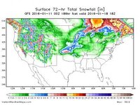
Sh!t sh!t sh!t... next weekend is falling apart...quickly. GFS has rain all the way to the Canadian border Saturday into early Sunday, with snow finishing the event off... but mostly rain. EURO is a bit colder. But there are a lot of variables with this storm and the surrounding area. Gotta see how things develop, but as of now what we need isn't in play.


GFS "snowfall" (or lack of) from late Friday to late Monday

USA_ASNOWI72_sfc_186.jpg


Hopefully Tuesday's snow showers remind Flatlanders that it is in fact winter and drives up ticket sales up north.
 
Top