-
Welcome to AlpineZone, the largest online community of skiers and snowboarders in the Northeast!
You may have to REGISTER before you can post. Registering is FREE, gets rid of the majority of advertisements, and lets you participate in giveaways and other AlpineZone events!
You are using an out of date browser. It may not display this or other websites correctly.
You should upgrade or use an alternative browser.
You should upgrade or use an alternative browser.
Week of Feb 10-16
- Thread starter billski
- Start date
billski
Active member
billski
Active member
St. Bear
New member
Let's see here...
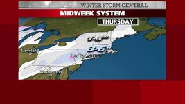
A solid manmade base + 5-10" last weekend + 6" this week + potential storm this weekend = Poconos going off
legalskier
New member
- Joined
- Sep 22, 2008
- Messages
- 3,052
- Points
- 0
Let's see here...
A solid manmade base + 5-10" last weekend + 6" this week + potential storm this weekend = Poconos going off
Looks like that pink area covers Blue Mt.
hammer
Active member
I'm more interested in what the models are saying about the weekend...this mid week system doesn't look like it will do anything for NNE.
from_the_NEK
Active member
I'm more interested in what the models are saying about the weekend...this mid week system doesn't look like it will do anything for NNE.
Umm yeah. The GFS has a something HUGE coming up the coast next Sunday/Monday. The noontime model run pushed it a little offshore but it is still a week out.
ScottySkis
Well-known member
It will happen, I doubt I will skiing this weekend.
BenedictGomez
Well-known member
If a big storm does materialize this weekend, the timing will be Saturday evening to Sunday. Havent looked at the wind models yet to see if Sunday would be theoretically be pleasant or an all lifts on wind hold kind of day. Hopefully it's the former, because Monday is always the travel back home day for me.
gmcunni
Active member
If a big storm does materialize this weekend, the timing will be Saturday evening to Sunday. Havent looked at the wind models yet to see if Sunday would be theoretically be pleasant or an all lifts on wind hold kind of day. Hopefully it's the former, because Monday is always the travel back home day for me.
has the weekend storm fizzled? i can't seem to find anyone talking about it (not that i have a lot of sources for that stuff)
For Sugarbush I see Fri 1 to 4 Sat 1 to 3 and Sun 1...so yeah looks to have fizzled a bit unless they get those high end amounts. Did not check any other areas though as i'm heading up to da bush next Thu.has the weekend storm fizzled? i can't seem to find anyone talking about it (not that i have a lot of sources for that stuff)
hammer
Active member
According to NWS it has...:sad:has the weekend storm fizzled? i can't seem to find anyone talking about it (not that i have a lot of sources for that stuff)
THE LARGE COASTAL LOW THAT THE GFS WAS TRYING TO PUSH INTO THE REGION ON SUNDAY IS NOW NOTHING BUT A LOW FOR THE FISHES AND PASSES WELL SOUTH AND EAST OF THE BENCHMARK...BEING NO THREAT ALL TO OUR AREA.
gmcunni
Active member
well, at least the ride up will be free of weather delays.. as i sit there with all the other pres weekend peeps.
thanks for the info (even tho it wasn't what i wanted )
)
thanks for the info (even tho it wasn't what i wanted
ZYDECORICH
Member
well, at least the ride up will be free of weather delays.. as i sit there with all the other pres weekend peeps.
thanks for the info (even tho it wasn't what i wanted)
Something to make fell better(or dream about). A friend of mine is going to this place. I hate him.
|
gmcunni
Active member
i never heard of Ruby MTN before but looks awesome.
ZYDECORICH
Member
not to get off the weather track but here's a background.i never heard of Ruby MTN before but looks awesome.
Located about halfway between Reno and Salt Lake City off a lonely stretch of Interstate 80, Ruby Mountains Heli-Experience offers an Alaska-size day of powder shots in the Lower 48. Only in the isolated Ruby Mountains, you won’t have to share any of it with other backcountry skiers or snowboarders. Plus, this overlooked little range offers the ideal terrain for big mountain powder with ten peaks topping out over at 11,000 feet (3,353 meters) and an average of 300 inches (nearly 8 meters) of dry, desert snow each year—not necessarily Alaska levels, but the snow here is pure western fluff.
The best package consists of three days of flying to untracked skiing in terrain ranging from trees to open glades to steeps (depending upon conditions), with a guarantee of 39,000 vertical feet (11,887 meters) of turns for the trip. If the weather grounds your bird, the guides will still take you out cat-skiing and prorate your bill according to the amount of vertical you missed by not flying.
Best of all, when your legs are shot, you can relax back at the ranch. Reds Ranch (www.redsranchnv.com), that is, a ten-bedroom lodge that features in-room massages and gourmet meals. And save room for dessert: After eating up powder all day and feasting at the lodge, you’ll be served a seven-layer opera cake and a glass of Crown Royal.
I could deal with that. I like the idea that they cat you to a spot if you can't get there by heli and pro rate the price.
BenedictGomez
Well-known member
has the weekend storm fizzled? i can't seem to find anyone talking about it (not that i have a lot of sources for that stuff)
Yeah, looks like the Euro was right again. OTS I think.
ScottySkis
Well-known member
Well I think it will snow because I have to visit someone close to, so no skiing for me, chances are it will snow for you guys, I hope.
bheemsoth
Member
Maybe time to start discussing this again? Chatter has picked up following the last couple of model runs.
Sent from Samsung Galaxy S3 using Tapatalk 2
Sent from Samsung Galaxy S3 using Tapatalk 2
St. Bear
New member
Henry Margusity from Accuweather put up this map, and said he could easily see this overperform to the tune of 8-9". Unfortunately, it favors the areas that just got pummeled by Nemo.


Similar threads
- Replies
- 62
- Views
- 13K
- Replies
- 2
- Views
- 4K
- Replies
- 46
- Views
- 10K


