billski
Active member
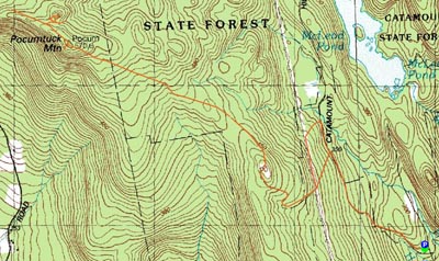
Spent a rewarding day discovering lost roads, flagging them and doing a bit of clearing. CSF has a lot to offer, it's a shame that there is no good map or trail maintenance. There's the abandonded town of Catamount Hill, the schoolhouse marker and flag, the lake and the mountain, with lots of good tromping to be had. I've been spending time uncovering trails and clearing them. We've got a date of July 18th for a larger partee (you ARE invited) to clear the way to Pocumtuck Mountain.
Anyways, I accomplished a lot, flagging two more trails and uncovering the beginnings of a third before the sun set on me. It was a day of ongoing bushwhacking and discovery. On a previous trip, I had flagged one road northbound, west of the power lines until it became clear it wasn't the path to the mountain summit. Being the curious cat that I am, I decided to to finish the trek, to see if I could make a circular hiking route.
This was a day for compass, map and (grrr :twisted: GPS) work. I headed N on Catamount Hill Road, first on quest to find the schoolhouse marker. After bypassing the road due to beaver activity, and bearin L, I came upon the old schoolhouse site, where the first flag was raised over a school house in the US. I cleared the brush and cut up the downfall that blocked the marker and continued on.
I had information that suggested the trail begin W from the road, crossed the power line ROW and continued S. After about 1/2 hour of wandering the ROW, I uncovered a forest road heading W. As I got further into the woods, it became clear this was going in the correct direction. I pursued a SW course, heading toward the place where I had abandoned the search last time. The coolest part was actually meeting up with the road I first abandoned after having stopped flagging the first time. It was really pretty cool to meet up with flags from an earlier trip. It reminded me of the meeting of the transcontinental railroad (though not at scale!)
I then made it back up to the nob (Mills Camp/chimney) and proceeded to clarify the trail junctions with tape. Coming off the nob, heading E now, I began to search for the N-S trail that proceeds to River Road. After about 10 minutes, I found it, perhaps even less evident than the forests roads. I flagged that trailhead, but I was parked in the wrong spot to head down there.
I also trekked and partially marked some other spur roads.
After that, I putzed around looking at old cellar holes abandonded 160 years ago.
Met three locals along they way, all interested in joining the trail clearing partee on the 18th. All were surprised at what I uncovered.
I plan to put all this knowledge into an integrated map and provide it to DCR sometime over the next several months. Right now, it's time to be on the trail. Priority will be on Pocumtuck Mountain trail, as it has so much to offer, it’s a nice 1.5 mile each way trip to a cliff summit with an expansive westward view of the Berks.
Because most of my work involved bushwhacking, the compass and map were essential. I've had a GPS for about a year, but am only marginally competent. I wish someone had told me that the Garmin compass function needed to be re calibrated after every battery change. Out in the woods, the Garmin compass didn't behave and I don't carry the instructions manual with me! I think I've got it this time, but there are almost too many settings. I wish it had a "hiking" mode, which presets all the choices to a "pretty close" use case and then I can tweak. The GPS tries to be too many things - I don't need it as a car navigator. Grrr!
I will probably get back there next weekend to scout out one more trail for clearing. If you can't make the 18th, there are plenty of trails that you could clear on your own - I'll have everything flagged. There are weeks and weeks worth of work out there.