• Welcome to AlpineZone, the largest online community of skiers and snowboarders in the Northeast!

    You may have to REGISTER before you can post. Registering is FREE, gets rid of the majority of advertisements, and lets you participate in giveaways and other AlpineZone events!

January 2nd - 3rd storm

WJenness

Active member
Joined
Oct 18, 2007
Messages
3,024
Points
38
Location
Lowell, MA
Picking up my powder boards from REI today...

If anyone needs me, I'll be hiding in the mountains.

:daffy:
 

aenshech

New member
Joined
Dec 30, 2013
Messages
2
Points
0
I was at mountain creek yesterday and it was a disaster. Rain didn't stop and got soaked through and through. The snow became like slush

Sent from my GT-I9500 using AlpineZone mobile app
 

wa-loaf

Well-known member
Joined
Jan 7, 2007
Messages
15,109
Points
48
Location
Mordor
Matt Noyes:

  1. It's very likely to snow Thursday in New England, not only owing to the developing storm, but also owing to the predicted northeast wind off the Atlantic Ocean into an antecedent arctic airmass.
  2. Temperatures Thursday are unlikely to exceed the teens for highs as snow falls into our arctic air.
  3. A six inch or greater snowfall seems quite likely for Southern New England.
  4. The average snowfall from similar atmospheric setups in history has yielded an average of 6-10" of snow, so that's a good starting point for Southern New England.
  5. Amounts could be much higher, with blizzard conditions realized Friday morning and snow extending well into Northern New England, too, if a stronger of the potential scenarios verifies.
  6. Tides will be quite high on January 2nd and 3rd, so if a stronger solution verifies, substantial coastal flooding and beach erosion will be a serious concern, if a weaker solution verifies, some minor coastal flooding still quite likely given persistent onshore wind.
So...where are we left for Thursday into Friday? Overall, low-end guidance supports a 6-12" snowfall for Southern New England, with very little in Northern New England. High-end guidance supports a couple of feet for much of New England in an all-out blizzard.

http://www.mattnoyes.net/new_englan...MATTNOYES.NET+-+NEW+ENGLAND+WEATHER+ANALYSIS)
 

BenedictGomez

Well-known member
Joined
Jan 26, 2011
Messages
12,552
Points
113
Location
Wasatch Back
The US government model (GFS) is out and it caved to the Euro as per usual.

Though the GFS brings the snow WAY far south, which wouldnt be good for ski country, BUT the GFS tends to be too south with these winter storms so in a way it's almost a good sign for ski country if that makes sense.

At any rate, now every major model's guidance is clearly showing a rather big snowstorm for this time period, only the path and jackpot zone is argued now.
 

skifree

New member
Joined
Oct 16, 2012
Messages
664
Points
0
looks like cold and fluffy. have to get in position for this one!
 

JDMRoma

Well-known member
Joined
Jan 20, 2013
Messages
1,262
Points
48
Location
Hudson NH
The US government model (GFS) is out and it caved to the Euro as per usual.

Though the GFS brings the snow WAY far south,

Hmm what are you saying....I should bring my ski's to work with me to hit up Blue hills ?
It better go North....:)
 

BenedictGomez

Well-known member
Joined
Jan 26, 2011
Messages
12,552
Points
113
Location
Wasatch Back
Hmm what are you saying....I should bring my ski's to work with me to hit up Blue hills ?
It better go North....:)

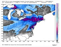
Here.... I may as well post the 12z snowfall map I suppose.

GFS 12z.jpg

As you can see, the GFS prediction isnt nearly as good for ski country as the Euro map. But what I was saying is that the GFS tends to be too far south with these northeast winter storms. We've seen it again and again and again over the last few years.

So it wouldn't shock me if the Euro winds up being right.......... yet again.
 

BenedictGomez

Well-known member
Joined
Jan 26, 2011
Messages
12,552
Points
113
Location
Wasatch Back
12z Euro is out and it's south of the 00z Euro run, but north of the above 12z GFS.

Would be worse for most of New England + Dax, but still great for Cats and Poconos. Will be interesting to see what the Euro ensembles say when they come out in a bit (i.e. did the Euro really jog south or is the operational run an outlier).
 

flightschool

Member
Joined
Dec 29, 2013
Messages
91
Points
8
Great news indeed. I'm at the loaf now, thought they would get more than 4" from the last storm, but it didn't materialize. They have done minimal snow making, apparently their water reservoir has been problematic throughout the season so far.

Unrelated - I was at killington 27-28th December and conditions were better there than at the Loaf today (30th).
 

BenedictGomez

Well-known member
Joined
Jan 26, 2011
Messages
12,552
Points
113
Location
Wasatch Back
This is great news. Keep 'em coming!

Well, since you mentioned it, the Euro is sniffing out another large storm over the 5th and 6th.

That one needs to: A) Hold together B) shift a bit east

But if both of those materialize it would be a helluva 1-2 punch.
 

billski

Active member
Joined
Feb 22, 2005
Messages
16,207
Points
38
Location
North Reading, Mass.
Website
ski.iabsi.com
Did you see the scenarios that crapuweather is already putting out?
123013weatherA_dngnk.jpg


123013weather2a_dngnk.jpg
 
Top